Novide River facts for kids
Quick facts for kids Novide |
|
|---|---|

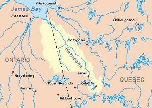
Harricana River basin in yellow
|
|
| Country | Canada |
| Province | Quebec |
| Region | Eeyou Istchee Baie-James (municipality) |
| Physical characteristics | |
| Main source | Creek in marsh area Eeyou Istchee Baie-James (municipality), Nord-du-Québec, Quebec 16 m (52 ft) 41°17′27″N 79°05′44″W / 41.29083°N 79.09556°W |
| River mouth | James Bay Eeyou Istchee Baie-James (municipalité), Nord-du-Québec, Quebec 0 m (0 ft) 51°32′05″N 79°15′15″W / 51.53472°N 79.25417°W |
| Length | 30.2 km (18.8 mi) |
| Basin features | |
| Tributaries |
|
The Novide River is a river in Quebec, Canada. It flows into Cabbage Willows Bay, which is part of James Bay. A river that flows into a larger body of water is called a tributary.
The Novide River is located in the James Bay Reserve. This area is part of the Eeyou Istchee Baie-James municipality in the Nord-du-Québec region.
During the colder months, the river's surface usually freezes. This happens from early November until mid-May. However, it's generally safe to travel on the ice from mid-November to mid-April.
Contents
Where is the Novide River?
The Novide River is surrounded by other important waterways. These are called hydrographic slopes. Think of them as the areas where water drains into different rivers or bays.
- North: Cabbage Willows Bay, Rupert Bay, James Bay, and Inenw Passage.
- East: Rupert's Bay, Nottaway River, and Broadback River.
- South: Iscouistic River, Missisicabi River, Octave River (Rupert Bay), and Harricana River.
- West: Harricana River and Hannah Bay.
Where the River Starts
The Novide River begins in a marshy area. This starting point is about 29.4 kilometres (18.3 mi) east of the Ontario border. It's also about 29.6 kilometres (18.4 mi) southeast of where the Novide River meets Cabbage Willows Bay.
How the River Flows
The Novide River flows for about 38.0 kilometres (23.6 mi). It runs along the western side of the Nesukauchi hill.
The river's path can be divided into two main parts:
- For 19.4 kilometres (12.1 mi), it flows northwest through marshy areas. Along this part, it collects water from Kachiskamisechishit Creek, which comes from the south.
- Then, for 18.6 kilometres (11.6 mi), it flows westward, still through marshy areas. Here, it collects water from Nistam Utameu Creek, also coming from the south. Near its end, it crosses about 1.7 kilometres (1.1 mi) of sandstone.
Where the River Ends
The Novide River empties into Hannah Bay. This bay is located on the eastern side of James Bay in Quebec.
The mouth of the Novide River is:
- Only 12.1 kilometres (7.5 mi) north of where the Harricana River ends.
- About 103.8 kilometres (64.5 mi) east of the mouth of the Moose River, Ontario.
- About 34.9 kilometres (21.7 mi) west of the mouth of the Nottaway River.
What's in a Name?
The name "Novide" comes from the French language.
The official name "Novide River" was made formal on December 5, 1968. This happened when the Commission de toponymie du Québec (Quebec's Place Names Commission) was created. This commission is in charge of naming places in Quebec.
 | Bayard Rustin |
 | Jeannette Carter |
 | Jeremiah A. Brown |

