
Oakwood, Staten Island facts for kids

Oakwood is a neighborhood located in Staten Island, New York City. It's on the east side of Staten Island, close to the South Shore. Oakwood is bordered by Tysens Lane to the north, the Atlantic Ocean to the east, Great Kills Park to the south, and Kensico Street and Clarke Avenue to the west.
The neighborhood has a coastline along the Lower New York Bay. This coastal area is sometimes called Oakwood Beach. A facility that treats wastewater is located here. South of this facility is the Staten Island part of the Gateway National Recreation Area, which many people know as Great Kills Park.
Oakwood's ZIP Code is 10306. The mail for this area is handled by a post office in New Dorp, which is a community just north of Oakwood.
Contents
A Look at Oakwood's Past
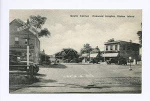

Until the mid-1900s, Oakwood was mostly farmland in its higher areas and a beach resort near the ocean. The neighborhood started to become more like a suburb when there was a plan for a Staten Island Tunnel to connect to the New York City Subway.
Development really sped up after the Verrazzano-Narrows Bridge opened in November 1964. Today, Oakwood is a middle-class neighborhood. It has many one- and two-family homes, as well as garden apartments. Important shops and businesses are found along Hylan Boulevard.
In October 2012, Hurricane Sandy caused a lot of damage to Oakwood Beach. Because of the damage and the area's low elevation, homeowners were given a choice a year later. They could choose to have the government buy their homes. This plan, called managed retreat, would turn the area into an empty buffer zone. This buffer zone would help protect against future storms.
Places to See in Oakwood
Oakwood has several interesting places. One is Monsignor Farrell High School. There are also several cemeteries on the southwest side of the neighborhood. The most well-known is Frederick Douglass Memorial Park. This is an African-American burial ground. It's unique because very few African-Americans live in Oakwood or the areas around it. Historic Richmond Town, a historic village, is also very close by to the west.
The greenbelt woods along Riedel Avenue hold some old concrete pieces. For example, you might find a piece of sidewalk near the pond at Riedel and Thomas Street. You can also sometimes find signs of the Great Depression along the trails. These include bricks, chimneys, or foundations of houses that once stood there when the area was still rural. The trails along Riedel Avenue were once planned for the Willowbrook Parkway. They also have large boulders that were left behind by glaciers during the Ice Age.
Amundsen Circle: A Tribute to an Explorer
_jeh.jpg)
Amundsen Circle, officially known as Captain Roald Amundsen Plaza, is a traffic circle and a park. It covers about 1.05 acres (4,250 square meters). This park is surrounded by Amboy Road, Clarke Avenue, and Savoy Street.
Amundsen Circle and the 4.5-mile (7.2 km) Amundsen Trail for joggers both honor the famous explorer Roald Amundsen. The city bought the land for the park in 1928. It was officially named on July 9, 1929. Inside the park, there is a stone plaque. It was put up in 1933 by the Norsemen Glee Club of Staten Island and the Norwegian Singing Society of Brooklyn. At that time, many Norwegian people lived in Oakwood. The Richmond Ever-Green Garden Club helps maintain the park today.
Getting Around Oakwood
The Staten Island Railway serves the neighborhood at its own station, called Oakwood Heights. For bus service, Oakwood Heights has several local buses, including the S57, S76, S78, S79 SBS, S86 routes. There are also express buses for longer trips, such as the SIM1, SIM5, SIM6, SIM7, SIM9, SIM10, SIM22 routes.
See also
 In Spanish: Oakwood (Staten Island) para niños
