
Ogunquit, Maine facts for kids
Quick facts for kids
Ogunquit, Maine
|
||
|---|---|---|

Ogunquit Public Library
|
||
|
||

Ogunquit, Maine
Location in Maine
|
||
| Country | United States | |
| State | Maine | |
| County | York | |
| Incorporated | 1980 | |
| Area | ||
| • Total | 15.25 sq mi (39.50 km2) | |
| • Land | 4.18 sq mi (10.83 km2) | |
| • Water | 11.07 sq mi (28.67 km2) | |
| Elevation | 141 ft (43 m) | |
| Population
(2020)
|
||
| • Total | 1,577 | |
| • Density | 377/sq mi (145.6/km2) | |
| Time zone | UTC−5 (Eastern (EST)) | |
| • Summer (DST) | UTC−4 (EDT) | |
| ZIP Code |
03907
|
|
| Area code(s) | 207 | |
| FIPS code | 23-54980 | |
| GNIS feature ID | 0582646 | |

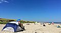
Ogunquit (pronounced oh-GUN-kwit) is a beautiful resort town in York County, Maine, United States. It's famous for its sandy beaches and charming coastal vibe. In 2020, about 1,577 people lived there. Ogunquit is part of the larger Portland area.
Contents
History of Ogunquit
Ogunquit began as a small village within the town of Wells, which was settled in 1641. Early on, people built the first sawmill in 1686. Shipbuilding also became important along the Ogunquit River. Local shipbuilders created different types of boats like schooners, brigs, and dories.
How Perkins Cove Was Formed
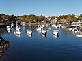
Near a river called the Josias, there was a place called Fish Cove. Fishermen worked here, but the cove wasn't safe from big Atlantic storms. They had to pull their boats out of the water every night to protect them. To solve this, the fishermen formed a group and dug a channel to connect Fish Cove to the Josias River. Over time, this channel grew wider, creating a safe harbor called Perkins Cove. Today, a special footbridge that can be opened by hand crosses the cove.
Ogunquit Becomes an Art Colony
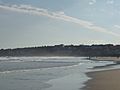
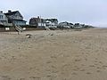
Ogunquit has a long, pale sand beach and dunes that form a natural barrier. In 1888, a bridge connected this beach area to the mainland. Soon, artists discovered the village and its beautiful scenery. It quickly became a popular art colony and a favorite spot for tourists. After 1898, when the Ogunquit Art Colony was officially started, it was common to see both artists painting and fishermen working around Perkins Cove. Many hotels and inns were built to welcome the summer visitors.
Marginal Way and Town Incorporation
The Marginal Way is a famous scenic trail that started in the 1920s. It runs along the coast from Perkins Cove to Ogunquit Beach, offering amazing views. Ogunquit officially separated from Wells in 1980 and became its own town. In 2016, USA Today named Ogunquit America's Best Coastal Small Town. In 2023, Tripadvisor also ranked Ogunquit Beach as one of the top 10 beaches in the United States.
Education in Ogunquit
The Wells-Ogunquit Community School District provides education for students of all ages. This district serves both the towns of Wells and Ogunquit in southern Maine.
Geography of Ogunquit
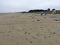
Ogunquit covers about 15.25 square miles (39.50 square kilometers). Most of this area is water, with about 4.18 square miles (10.83 square kilometers) being land. The town is drained by the Josias and Ogunquit Rivers. The highest point in Ogunquit is about 160 feet (49 meters) above sea level. The lowest point is at sea level, along the Atlantic Ocean.
Soils and Climate
The soil in Ogunquit is mostly stony or sandy, formed from glacial till. These soils are known as Lyman or Adams/Croghan series. Ogunquit has a humid continental climate. This means it has big differences in temperature throughout the year, with warm to hot summers and cold winters.
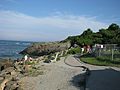
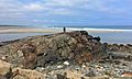
The Marginal Way
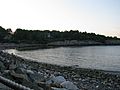
Ogunquit's Marginal Way is a 1.25-mile (2-kilometer) paved path with stunning views of the coast. Some parts of the path along the cliffs have fences to keep people safe. The path connects the main shopping area of downtown to the fishing village in Perkins Cove. Perkins Cove is now a fun outdoor area with shops selling jewelry, clothes, and other unique items.
Population of Ogunquit
The population of Ogunquit changes throughout the year, with more people visiting in the summer.
- 1970: 944
- 1980: 1,492
- 1990: 974
- 2000: 1,226
- 2010: 892
- 2020: 1,577
Cultural Sites and Museums
Ogunquit has several interesting places to visit:
- Barn Gallery | Ogunquit Art Association (started 1928)
- Historical Society of Wells and Ogunquit (started 1862) (located in Wells)
- Ogunquit Museum of American Art
- Ogunquit Playhouse
- Captain James Winn House (built around 1785)
- Ogunquit Memorial Library
Notable People
Many interesting people have lived in or been connected to Ogunquit:
- Clarence H. Adams, a commissioner for the U.S. Securities and Exchange Commission and former President of the Boston Celtics.
- Marjorie Agosín, an award-winning poet, writer, and professor.
- Edward H. and Gladys G. Aschermann, designers from the early 1900s.
- John Kendrick Bangs, an author.
- Bobby Coombs, a Major League Baseball pitcher.
- Joseph B. Davol, a marine painter and art teacher.
- Nathan Haskell Dole, an author.
- Totie Fields, an actress and comedian.
- Arnie Ginsburg, a radio personality.
- Peter George Olenchuk, a U.S. Army Major General.
- J. Scott Smart, a radio, film, and stage actor.
- Sally Struthers, an actress.
- Craig Timberlake, a stage actor, singer, author, and educator.
- John Grimes Walker, an admiral in the United States Navy.
- Charles Herbert Woodbury, an artist.
- Channing Hare, a painter.
- Mountfort Coolidge, a painter and antiquarian.
Trivia
- Ogunquit Beach is also the name of a place on Mars! Scientists believe it was once underwater or on the shore of an ancient lake.
- Part of Stephen King's famous book The Stand, published in 1978, is set in Ogunquit. The first episode of the 2020 TV show based on the book also takes place in the town, even though it was filmed in Vancouver.
Images for kids
-
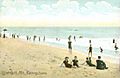
Ogunquit Beach around 1910
-

Perkins Cove from Marginal Way around 1920
-
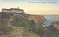
The Cliff House around 1920
-
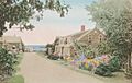
Perkins Cove Road around 1920
-

Ogunquit River at high tide in August 2006.
-

Ogunquit River at low tide the same month. Ogunquit's beach nearly disappears at high tide.
-

The Ogunquit River flows into the Gulf of Maine.
-
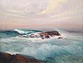
Surf at Ogunquit, Maine by Edward A. Page (around 1911)
-
The beach along the Marginal Way, 2008
-
The Marginal Way near the Beachmere Hotel, 2008
-
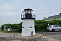
Lobster Point Lighthouse found along Marginal Way
-
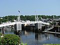
The bridge at Perkins Cove, 2008
-
View from the Bridge at Perkins Cove, 2007
-
The beach at Perkins Cove looking toward the Marginal Way, 2008
-
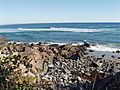
Rock formation at Marginal Way
-
Ogunquit Beach, 2008
-
Kites flown at Ogunquit Beach
-
North Beach
-
Moody Beach


See also
 In Spanish: Ogunquit para niños
