
Ol Doinyo Lengai facts for kids
Quick facts for kids Ol Doinyo Lengai |
|
|---|---|
| Oldoinyo Lengai | |
 |
|
| Highest point | |
| Elevation | 2,962 m (9,718 ft) |
| Geography | |

Ol Doinyo Lengai
Location in Tanzania
|
|
| Geology | |
| Formed by | Volcanism along the Gregory Rift |
| Mountain type | Stratovolcano |
| Last eruption | 2024 |

Ol Doinyo Lengai is an active volcano in northern Tanzania. It is famous for its unique lava, which is different from any other volcano on Earth. This special lava is called natrocarbonatite. It flows at much lower temperatures than regular lava. The volcano has two main craters at its top. The northern crater has been active in recent times. Eruptions in 2007 and 2008 affected the areas nearby.
Contents
Discovering Ol Doinyo Lengai
What's in a Name?
The Maasai and Sonjo tribes call this volcano "The Mountain of God". They have a story about their god, Engai, who lives there. Engai moved to the mountain after a hunter accidentally hit him with an arrow. Other names for the volcano include Basanjo and Oldonyo L'Engai.
Where is Ol Doinyo Lengai?
Ol Doinyo Lengai is located in the Arusha region of Tanzania. It sits about 16 kilometers (10 miles) south of Lake Natron. The city of Arusha is about 120 kilometers (75 miles) to its northwest. People first explored the top of the mountain between 1904 and 1915. Many people live in this area. Farming animals is a main way of life. However, tourism is also becoming very important.
How Ol Doinyo Lengai Looks
Ol Doinyo Lengai has a beautiful, cone-like shape. It rises more than 1,800 meters (5,900 feet) above the valley around it. At the very top, there are two craters. A ridge about 110 meters (360 feet) high separates them.
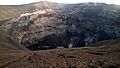
The northern crater is often filled with lava flows. These flows look like wrinkled ropes. Small cones, from 2 to over 10 meters (6 to 33 feet) tall, grow inside this crater. They can erupt lava from their tops or sides. The southern crater is not active. Sometimes, it even fills with water. White volcanic ash covers the volcano's sides. There are also large cracks on its western side. Smaller vents, called parasitic vents, are found on the volcano's slopes. These include Kirurum Crater and the Nasira cones.
Around the volcano, you can see signs of past debris avalanches. These are like giant landslides. One such event left a big scar on the volcano's side. Earthquakes and cracks in the ground might have caused these avalanches.
The Science Behind the Mountain
How the Earth Moves Here
Ol Doinyo Lengai is part of the Gregory Rift. This is a large crack in the Earth's surface. It is part of the active East African Rift. The East African Rift stretches for 4,000 kilometers (2,500 miles) across Africa. Here, the Earth's crust is thinner. This allows more heat to escape from deep inside the Earth.
The Gregory Rift started to pull apart about 1.2 million years ago. It is still moving today. The land is spreading at about 3 millimeters (0.1 inches) each year. A major crack, called the Natron Fault, runs near the volcano.
Ol Doinyo Lengai is also part of a group of volcanoes. These are called the Ngorongoro volcanic highlands. This area has been active for millions of years. Over time, the volcanic activity moved towards where Ol Doinyo Lengai is now. Other volcanoes nearby include Gelai and Ketumbeine. Famous places like the Olduvai Gorge and Kilimanjaro mountain are also in this region.
What Makes Its Lava Special?
Most of Ol Doinyo Lengai's cone is made of common volcanic rocks. However, it is the only volcano on Earth known to erupt carbonatitic lavas in modern times. These lavas are very special. They are made mostly of carbonate compounds. They only appear in the northern crater.
Scientists have studied Ol Doinyo Lengai's unique lava. They use it to understand what carbon planets might be like. These are planets thought to be rich in carbon.
The carbonatite lavas change quickly when it rains. They turn white, like snow, or get covered by gases from the volcano. This creates new minerals on the lava flows. The rocks that make up the volcano can change over time. After 2007–2008, more of the common volcanic magma appeared.
Scientists believe there are two pools of magma under the volcano. The way the magma moves is complex. It is affected by the large cracks in the Earth's surface.
Gases from the Volcano
The gases coming from Ol Doinyo Lengai are mostly water vapor and carbon dioxide. These gases come from deep inside the Earth, from the mantle. This volcano releases a lot of carbon dioxide. It produces about 80 kilograms (176 pounds) of CO2 every second.
A History of Eruptions
Geologists have studied the volcano's past. They believe eruptions at Ol Doinyo Lengai started between 500,000 and 22,000 years ago. The volcano grew in two main stages. Its cone was mostly complete about 15,000 years ago. The volcano has collapsed several times in its long history. The oldest special carbonatite lavas are about 1,250 years old.
About 3,000 to 2,500 years ago, an eruption spread ash to the west. This ash is now being shaped by the wind into dunes. These include the famous Shifting Sands in the Olduvai Gorge. Another big eruption about 1,250 years ago left ash in the gorge. And about 600 years ago, an eruption formed the "Footprint Tuff." Ol Doinyo Lengai is the only active volcano in the Gregory Rift today.
Records of eruptions go back to the 1880s. The volcano is almost always active. However, people don't always see its activity. It often erupts ash and lava flows from its northern crater. In the mid-1900s, the crater was about 200 meters (650 feet) deep. Later, lava flows filled it up. By 1998, lava was even spilling over the edges. The lava comes from small cones inside the crater. It forms pools and lakes of lava.
Big, explosive eruptions are less common. They happened in 1917, 1940, 1966, 1983, and 1993. Steep slopes can cause landslides. Rain has also carved deep channels into the volcanic deposits. Sometimes, steam also shoots out from the volcano.
Scientists use satellites to watch the volcano. They have seen the volcano's shape change during eruptions. They also noticed movement in nearby cracks in the Earth. This movement is caused by magma from Ol Doinyo Lengai.
Recent Activity: 1983 to Today

After a quiet period, the volcano became active again in 1983. It has continued to erupt with some breaks since then. During the 1983 eruption, ash fell many kilometers away. After this, lava started flowing inside the top crater. A geographer named Celia Nyamweru lived nearby. She recorded what the crater looked like through the 1980s. In 2006, lava flowed onto the western side of the volcano. This also created a new pit crater at the summit.
A very large explosive eruption started on September 4, 2007. It sent an eruption column 3 kilometers (1.9 miles) high into the sky. A new crater, 100 meters (330 feet) deep and 300 meters (980 feet) wide, was formed. This explosive activity continued into 2008. After that, the volcano went back to flowing lava. A small cinder cone grew in the northern crater during this time. Clouds of ash from the eruption spread over East Africa.
The 2007 eruptions caused three villages to be evacuated. They also disrupted air travel in this popular tourist area. Animals died, and people were hurt. This led to calls for the Tanzanian government to limit access to the volcano. It also made people more aware of the danger. Wild animals, like flamingos, were also affected. Before the eruption, there was a lot of earthquake activity in July. People often thought these were new eruptions. Also, a crack filled with magma formed less than 20 kilometers (12 miles) from Ol Doinyo Lengai.
The Amazing Cold Lava

The lava from Ol Doinyo Lengai is truly unique! When it first erupts, it can be brown or black. But within hours or days, it turns white, just like snow. This lava is also much cooler than other lavas. It has temperatures between 540 and 593 degrees Celsius (1,000-1,100 degrees Fahrenheit). This is so cool that during the day, it looks like mudflows or oil. It only glows at night!
This lava is also very fluid. It can flow very fast, between 1 and 5 meters (3 to 16 feet) per second. This makes it the most liquid lava known. It forms short flows, only a few tens of meters long. The flows are also very thin, just a few centimeters thick. Sometimes, thicker, stickier lava flows have also been seen, like during the 1993 eruption.
Staying Safe Near the Volcano
Scientists are still learning about the dangers from Ol Doinyo Lengai. Potential threats include mudslides (lahars), landslides, lava flows, and falling ash. There can also be hot, fast-moving clouds of gas and ash (pyroclastic flows). Volcanic bombs (rock fragments) and harmful gases are also risks. Since 2016, the volcano has been watched closely. Scientists use a seismometer to detect earthquakes. They also use GNSS stations to measure ground movement.
Life Around Ol Doinyo Lengai
The area around the volcano is mostly grassland. This green land reaches up to 1,750 meters (5,740 feet) above sea level. The volcanic ash from Ol Doinyo Lengai actually helps the plants grow. It makes the soil rich in nutrients. Rain falls during two wet seasons. These are from March to May and from October to December.
Images for kids
-
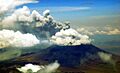
Ol Doinyo Lengai erupting in March 2008
-
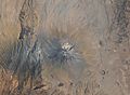
Satellite image (2009) of Ol Doinyo Lengai after an explosive eruption
-
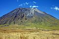
Ol Doinyo Lengai in February 2012
-
Aerial photo of Oldoinyo Lengai in January 2011
-
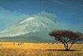
Image of 1966 eruption
-
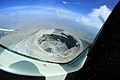
Crater of Ol Doinyo Lengai in January 2011


.jpg)
See also
 In Spanish: Ol Doinyo Lengai para niños
- List of volcanoes in Tanzania
