
Old Village Historic District (Monroe, Michigan) facts for kids
Quick facts for kids |
|
|
Old Village Historic District
|
|

Looking north along M-125 toward River Raisin
|
|

Location in Michigan

Location in the United States
|
|
| Location | Monroe, Michigan |
|---|---|
| NRHP reference No. | 82002854 |
| Added to NRHP | May 6, 1982 |
The Old Village Historic District is a special area in Monroe, Michigan. It's a historic district, which means it's a place with many old and important buildings. This area includes the downtown part of Monroe.
The Old Village is the oldest settled spot in Monroe. People first planned it out in 1817. Some buildings here are even older, from the 1830s! You can see many different building styles here. This district is also part of the Pure Michigan Byways, a special scenic route. It was added to the National Register of Historic Places on May 6, 1982.
Contents
Discovering the History of Old Village
The Old Village area began in 1817. A local landowner, Joseph Loranger, gave the land. This was for setting up a village for the new Monroe County. Henry Disbrow designed the streets like a grid plan, similar to New York City. Streets were named after numbers.
Early Growth and Important Buildings
The city grew quickly along the River Raisin around 1830. Most people lived in the Old Village. This was where the government and businesses were located. The county courthouse was built in 1880. It stands where the county government has been since 1817. Monroe got its first post office in 1913.
Back then, many paper mills operated along the River Raisin. The Dundee Historic District was also settled nearby. Both areas used the river a lot and built several dams.
Moving Historic Buildings
The Navarre–Anderson Trading Post was built in 1789. It was once part of the Old Village. But new buildings threatened it. So, it was moved in 1894 and again in 1971. Now, it's far from the Old Village. The Sawyer House was built in 1873. You can find it at 320 East Front Street in the district.
The Custer Statue Story
On July 4, 1910, President William Howard Taft visited Monroe. He helped unveil a statue of George Armstrong Custer. Custer lived in Monroe when he was young. The statue was placed in the middle of a street intersection.
At first, there weren't many cars in Monroe. But as more cars appeared, the statue became a traffic problem. So, on June 20, 1923, the city moved it. It went to a quieter spot along the River Raisin. In 1955, it moved again to its current spot. Today, it's known as the George Armstrong Custer Equestrian Monument.
Changes Over Time
The Old Village hasn't changed much since the 1930s. In the 1960s, some old buildings were torn down. This made way for new buildings and parking lots. People thought the district looked old-fashioned.
Old Village Today
Today, the Old Village is still an important part of Monroe. It centers around M-125 (Monroe Street) and M-50 (Front Street). It stretches several blocks east and south. The River Raisin forms its northern border.
Most big businesses have moved to other parts of Monroe. But the Old Village is still home to the city's government and police. Along Monroe Street, you'll find small shops on the first floor. Apartments and offices are on the upper floors.
The Old Village also has the city hall and post office. You'll see the county courthouse and jail here too. The Monroe Bank & Trust headquarters is also in this area. There are also various small businesses and Monroe Middle School. You can also find larger houses. No big factories or industries are left here today.
The Old Village Historic District is right across the river from the East Elm–North Macomb Street Historic District and the St. Mary's Church Complex Historic District. It remains an active part of Monroe's economy.
Gallery
Historic Images
-
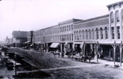
Front Street looking west toward the rest of the district in the year 1880 -
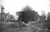
Front Street looking east toward the Old Village in the year 1900 -
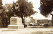
The original location of the Custer statue at Washington and East First (1910)

.png)

Modern Images
-

Monroe Middle School (1930), originally the high school, at 503 Washington Street -
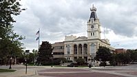
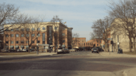
The current county courthouse (1880), located at 106 E. First Street -
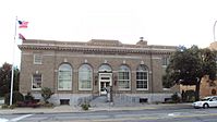
City's first post office (1913), at 126 S. Monroe Street, now the county museum -
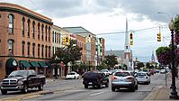
Downtown Monroe, looking south along M-125, known locally as Monroe Street -
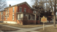
The early childhood home of J. Sterling Morton, located at 85 East Fifth Street -

The Old Village Historic District looking west along First Street -
The original location of the Custer statue with MB&T headquarters on the left -

The Old Village Historic District looking west along East Front Street


