
Olive Hill, Kentucky facts for kids
Quick facts for kids
Olive Hill, Kentucky.
|
|
|---|---|

Railroad Street
|
|
| Motto(s):
"A nice place to call home"
|
|

Location of Olive Hill in Carter County, Kentucky.
|
|
| Country | United States |
| State | Kentucky |
| County | Carter |
| Incorporated | March 24, 1884 |
| Government | |
| • Type | Mayor-Council |
| Area | |
| • Total | 2.02 sq mi (5.24 km2) |
| • Land | 1.99 sq mi (5.15 km2) |
| • Water | 0.03 sq mi (0.08 km2) |
| Elevation | 843 ft (257 m) |
| Population
(2020)
|
|
| • Total | 1,580 |
| • Estimate
(2022)
|
1,555 |
| • Density | 793.97/sq mi (306.55/km2) |
| Time zone | UTC-5 (Eastern (EST)) |
| • Summer (DST) | UTC-4 (EDT) |
| ZIP code |
41164
|
| Area code(s) | 606 |
| FIPS code | 21-57918 |
| GNIS feature ID | 2404430 |
Olive Hill is a small city in Carter County, Kentucky, in the United States. It is located along Tygarts Creek. In 2010, about 1,599 people lived there. By 2020, the population was 1,580.
Contents
History of Olive Hill
Olive Hill started as a rural trading post in the early 1800s. It was set up by the Henderson brothers. The town's name, Olive Hill, might have come from Elias P. Davis, who possibly named it after his friend Thomas Oliver. However, there is no clear proof of this.
Moving the Town and Becoming a City
In 1881, the town moved from a hillside to its current spot. This new location was in the Tygarts Creek valley. The Elizabethtown, Lexington, and Big Sandy Railroad had built train tracks there. The old hillside area became known as Old Olive Hill. Today, it is a residential part of the city.
On March 24, 1884, Olive Hill officially became a city. For a short time in 1904, from February to April, Olive Hill was the county seat of a new county called Beckham County. However, this county did not last long.
Railroad History
The Chesapeake and Ohio Railway (C&O) used to serve Olive Hill. This railroad line connected places like Ashland and Lexington. Later, the C&O merged into a system called Chessie System. Then, CSX Transportation bought out Chessie System. In the mid-1980s, CSX removed the railroad tracks.
Even though the tracks are gone, Olive Hill kept and restored its old passenger depot. They also have a caboose, which is now part of the "John Hop Brown" Memorial Park.
Geography of Olive Hill
Olive Hill is in the western part of Carter County. Most of the city is on the north side of Tygarts Creek. This creek flows into the Ohio River.
Major Roads and Nearby Cities
U.S. Route 60 goes through Olive Hill. If you go east on Route 60, you will reach Grayson, which is the county seat of Carter County, about 14 miles away. If you go west, you will get to Morehead, about 18 miles away.
Interstate 64 is about 3 miles north of Olive Hill. Going east on Interstate 64 will take you to Huntington, West Virginia, about 44 miles away. Going west will lead you to Lexington, about 84 miles away.
Land and Water Area
According to the United States Census Bureau, Olive Hill covers a total area of about 2.02 square miles (5.24 square kilometers). Most of this area is land, about 1.99 square miles (5.15 square kilometers). A small part, about 0.03 square miles (0.08 square kilometers), is water.
People in Olive Hill
In 2000, there were 1,813 people living in Olive Hill. There were 791 households and 488 families. The city had about 904 people per square mile. Most of the people living in Olive Hill were White (98.73%).
Population Changes Over Time
The population of Olive Hill has changed over the years:
| Historical population | |||
|---|---|---|---|
| Census | Pop. | %± | |
| 1880 | 56 | — | |
| 1890 | 186 | 232.1% | |
| 1900 | 291 | 56.5% | |
| 1910 | 1,182 | 306.2% | |
| 1920 | 1,395 | 18.0% | |
| 1930 | 1,484 | 6.4% | |
| 1940 | 1,491 | 0.5% | |
| 1950 | 1,351 | −9.4% | |
| 1960 | 1,398 | 3.5% | |
| 1970 | 1,197 | −14.4% | |
| 1980 | 2,539 | 112.1% | |
| 1990 | 1,809 | −28.8% | |
| 2000 | 1,813 | 0.2% | |
| 2010 | 1,599 | −11.8% | |
| 2020 | 1,580 | −1.2% | |
| 2022 (est.) | 1,555 | −2.8% | |
| U.S. Decennial Census | |||
Households and Families
Out of 791 households in 2000:
- 26.5% had children under 18 living with them.
- 44.5% were married couples living together.
- 14.5% had a female head of household with no husband present.
- 38.2% were not families.
About 34.8% of all households were made up of single people. Also, 18.6% had someone living alone who was 65 years old or older. The average household had 2.28 people, and the average family had 2.93 people.
Age Distribution
The population was spread out by age:
- 24.5% were under 18 years old.
- 8.3% were from 18 to 24 years old.
- 24.4% were from 25 to 44 years old.
- 24.4% were from 45 to 64 years old.
- 18.4% were 65 years old or older.
The median age in the city was 39 years.
Education in Olive Hill
Public schools in Olive Hill are managed by the Carter County School District. This district operates:
- Olive Hill Elementary School
- West Carter Middle School
- West Carter High School
Olive Hill also has a public library. It is a branch of the Carter County Public Library. You can find it on the third floor of the old Olive Hill High School building.
Famous People from Olive Hill
Olive Hill is the birthplace of country music singer and writer Tom T. Hall. He was known as "The Story Teller." This fact is even mentioned on the "Welcome to Olive Hill" signs at the edges of town.
Images for kids
-
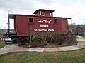
John "Hop" Brown Memorial park
-

Preserved Passenger Depot
-

Aerial view of the Olive Hill High School campus, Nov. 2022.


See also
 In Spanish: Olive Hill (Kentucky) para niños
