
Orosi, Cartago facts for kids
Quick facts for kids
Orosi
|
|
|---|---|
|
District
|
|

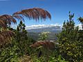
Orosi seen from the South
|
|

Orosi
Location in Costa Rica
|
|
| Country | |
| Province | Cartago |
| Canton | Paraíso |
| Area | |
| • Total | 376.41 km2 (145.33 sq mi) |
| Elevation | 1,051 m (3,448 ft) |
| Population | |
| • Total | 9,084 |
| • Density | 24.1333/km2 (62.505/sq mi) |
| Time zone | UTC−06:00 |
| Postal code |
30203
|
Orosi is a special area called a district in the Paraíso canton. It's located in the Cartago province of Costa Rica.
Contents
Orosi's Rich History
Orosi is one of the oldest places where people have lived in Costa Rica. Long ago, before the Spanish arrived in the 1500s, the Orosi Valley was home to different groups of native people. These included the Huetare, Cabecar, and Viceita tribes.
When the Spanish explorers came, they chose Orosi and another village called Ujarrás to build their first settlements. They picked this area because it had lots of water and very fertile land, which was perfect for farming.
Geography and Nature in Orosi
Orosi covers an area of about 376 square kilometers (145 square miles). It sits at an elevation of 1,051 meters (3,448 feet) above sea level.
This district is located about 35 kilometers (22 miles) south of San José, the capital city. Orosi is nestled in the deep Orosi Valley, right by the Reventazón River. The valley has a humid climate and is surrounded by green hills and thick plants.
What Grows in Orosi?
The main crop grown here is coffee. You'll see many coffee farms in the area. Orosi is also known for having the oldest Catholic church in Costa Rica that is still used today. This church, called Iglesia de San Jose de Orosi, was built way back in 1743 during the time when Spain ruled the area.
Orosi's Population
According to the 2011 census, Orosi had a population of 9,084 people.
Getting Around Orosi
You can reach Orosi by road. Several important roads connect the district to other parts of Costa Rica:
 National Route 2
 National Route 224
 National Route 405
 National Route 408
Economy and Tourism in Orosi
The Orosi region is famous for its amazing scenery. It has lush rain forests, towering volcanoes, rolling hills, and valleys filled with rows of coffee plants and sugar cane. It's one of the most beautiful places in Costa Rica!
Exploring Orosi's Past
This region is also rich in history. You can find old monuments, including a colonial capital city founded in 1563. There are even archaeological sites that show people lived here as far back as 1000 B.C. Even though Orosi was one of the first places settled in Costa Rica, it has only recently become a popular spot for tourists.
Discovering Tapantí National Park
Just a few kilometers away, at the southern end of the valley, you'll find the entrance to Tapantí National Park. This park covers about 600 square kilometers (230 square miles). It's the northern part of a huge group of nature parks that stretch all the way into Panamá. The largest of these is the La Amistad International Park.
Because of these large protected areas, there's a lot of wildlife in Tapantí National Park. It's a great place for ornithology (studying birds) because so many different kinds of birds live there. The park gets a lot of rain, up to 7,000 mm (275 inches) in the mountains, which helps everything grow so well. This heavy rainfall also provides drinking water for much of the nearby metropolitan area. Lake Cachí is also located nearby, to the northeast.
Gallery
-
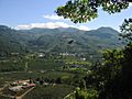
Coffee plantation just south of Orosi
-
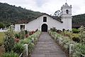
Iglesia de San Jose de Orosi
-
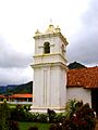
Church tower
-
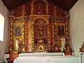
Church altar
-
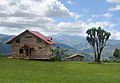
In the hills near Orosi
-

.jpg)


See also
 In Spanish: Orosi (Costa Rica) para niños
