Ouescapis Lake facts for kids
Quick facts for kids Ouescapis Lake |
|
|---|---|

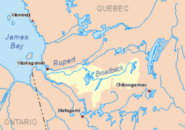
Watershed of Broadback River
|
|
| Location | Eeyou Istchee Baie-James (municipality) (RCM) |
| Coordinates | 50°14′51″N 76°59′52″W / 50.24750°N 76.99778°W |
| Type | Natural |
| Primary inflows | Some forested creeks |
| Primary outflows | Outlet of lake Ouescapis |
| Basin countries | Canada |
| Max. length | 21.1 kilometres (13.1 mi) |
| Max. width | 3.3 kilometres (2.1 mi) |
| Surface area | 4.72 kilometres (2.93 mi) |
| Surface elevation | 279 metres (915 ft) |
Lake Ouescapis is a freshwater lake in Quebec, Canada. It's part of the huge Broadback River system. You can find it in the Eeyou Istchee Baie-James area, which is in the Nord-du-Québec region.
The main activity around the lake is forestry, which means cutting down trees for wood. After that, people enjoy tourism and recreation here.
Getting to Lake Ouescapis is easy! You can use the James Bay road, which runs north-south from Matagami. It passes just west of the lake.
The lake usually freezes over from early November until mid-May. But it's safest to walk or play on the ice from mid-November to mid-April.
About Lake Ouescapis
Lake Ouescapis gets its water from many small streams along its banks. It's one of several long lakes in this area, found between the Broadback River and the Waswanipi River. These lakes often run parallel to each other. Some of its neighbors include Quénonisca Lake, Salamandre Lake (Broadback River), Opataouaga Lake, Amisquioumisca Lake, and Rocher Lake (Nipukatasi River). To the northwest, you'll find the larger Evans Lake.
Lake Ouescapis is about 21.1 kilometres (13.1 mi) long and 3.3 kilometres (2.1 mi) wide. It sits at an elevation of 279 metres (915 ft) above sea level and covers an area of 4.72 square kilometres (1.82 sq mi). Along its length, the lake has 14 islands and several bays.
Surrounding Areas
The land around Lake Ouescapis has some mountain peaks. The highest ones are about 358 metres (1,175 ft) tall, found on both the east and west sides of the lake.
Other nearby lakes include:
- Lake Poncheville, about 3.6 kilometres (2.2 mi) to the east.
- Opataouaga Lake, about 11.1 kilometres (6.9 mi) to the north.
- Quénonisca Lake, about 11.0 kilometres (6.8 mi) to the northeast.
- Matagami Lake, about 15.9 kilometres (9.9 mi) to the southwest.
Where the Water Flows
The water from Lake Ouescapis flows out from its northeast side. This outlet travels about 10.6 kilometres (6.6 mi) southeast, winding its way to the north shore of Lake Poncheville.
From Lake Poncheville, the water continues its journey for about 46.7 kilometres (29.0 mi) to reach the Broadback River. Here's how it flows:
- First, it goes 1.9 kilometres (1.2 mi) east through the northern part of Lake Poncheville.
- Then, it travels 7.5 kilometres (4.7 mi) northeast through a narrow passage called the "Détroit de Sable" (which means "Sand Strait").
- Next, it crosses Opataouaga Lake for 12.2 kilometres (7.6 mi) to the north, going around the "Île du Pain de Sucre" (or "Island of Sugarloaf").
- After that, it flows 14.8 kilometres (9.2 mi) north through an outlet and a bay of Quénonisca Lake.
- Finally, it goes 10.3 kilometres (6.4 mi) northeast until it joins the Broadback River.
Once the water reaches the Broadback River, it flows west for about 15.3 kilometres (9.5 mi) to Corbeau Bay, which is part of Evans Lake. After passing through Evans Lake, the water continues west along the Broadback River until it reaches the eastern shore of Rupert Bay.
Naming the Lake
The name Lake Ouescapis was officially chosen on December 5, 1968. This happened when the Commission de toponymie du Québec (Quebec's place-names commission) was first created.
 | John T. Biggers |
 | Thomas Blackshear |
 | Mark Bradford |
 | Beverly Buchanan |


