
Owens River course facts for kids
Quick facts for kids Owens River |
|
|---|---|

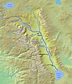
The Owens River course begins (top left) as Deadman Creek, and the river designation begins where the Big Springs tributary enters the Deadman Creek channel.
|
|
| Country | United States |
| State | California |
| Physical characteristics | |
| Length | 120 mi (190 km), north-south |
The Owens River is a river in southeastern California, United States. It flows for about 120 mi (190 km) from its start in the Sierra Nevada mountains to Owens Lake. The river is a very important source of water for Los Angeles, especially through the Los Angeles Aqueduct.
The Owens River and its surrounding area are known for their beautiful natural landscapes. These include high mountains, deep valleys, and unique desert plants. The river plays a big role in the environment and history of the region.

Contents
Where Does the Owens River Start?
The Owens River begins high up in the Sierra Nevada mountains. Its journey starts from small streams near the Sierra Crest. One of these early streams is called Deadman Creek.
The river officially gets its name, Owens River, when a stream called Big Springs joins Deadman Creek. This happens at an elevation of about 7,248 ft (2,209 m). From there, the river flows south through different landscapes.
The River's Journey Through Valleys and Reservoirs
After starting in the mountains, the Owens River enters Long Valley. This area is a large volcanic basin. The river flows through this valley, picking up water from other small streams.
What is Crowley Lake?
As the river continues its path, it flows into Crowley Lake. This is a large reservoir that holds a lot of the river's water. Many smaller creeks, like Convict Creek and Hilton Creek, also flow into Crowley Lake.
Crowley Lake is an important spot for fishing and outdoor activities. It helps manage the water flow of the Owens River. The lake is formed by the Long Valley Dam.
How Does the River Flow Through the Gorge?
After leaving Crowley Lake, the Owens River enters a narrow and deep canyon called the Owens River Gorge. This part of the river is very scenic. It shows how the river has carved its way through the land over many years.
The river then flows into Pleasant Valley Reservoir. This is another reservoir that helps control the water. After the gorge, the river enters the wider Owens Valley.
The Owens Valley and Water Diversion
The Owens Valley is a long, flat area between the Sierra Nevada mountains and other mountain ranges. As the Owens River flows through this valley, it is joined by several other creeks. These include Horton Creek and Bishop Creek.
What is the Los Angeles Aqueduct?
A very important part of the Owens River's story is the Los Angeles Aqueduct. This is a large system of pipes and canals built to carry water from the Owens River to the city of Los Angeles. The aqueduct was completed in 1913.
A big part of the river's water is diverted into the aqueduct. This means that a lot of the water that would naturally flow down the river is sent to Los Angeles instead. This diversion has had a big impact on the Owens Valley and Owens Lake.
Where Does the River End?
After much of its water is taken by the aqueduct, the remaining part of the Owens River flows towards Owens Lake. This lake is mostly dry now because so much water has been diverted from the river.
The river's mouth, or end point, is at Owens Lake. The lake bed is at an elevation of about 3,556 ft (1,084 m). The story of the Owens River and Owens Lake is a famous example of how water resources are managed and shared.
Images for kids
-
The Owens River course begins (top left) as Deadman Creek, and the river designation begins where the Big Springs tributary enters the Deadman Creek channel.
-
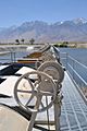
Diversion gates that control inflow to the Lower Owens River
