
Owensville, Indiana facts for kids
Quick facts for kids
Owensville, Indiana
|
|
|---|---|
| Town of Owensville | |

Row of buildings along east side of town square. Owensville Town Hall is on far left.
|
|

Location of Owensville in Gibson County, Indiana
|
|
| Country | United States |
| State | Indiana |
| County | Gibson |
| Township | Montgomery |
| Area | |
| • Total | 0.57 sq mi (1.47 km2) |
| • Land | 0.57 sq mi (1.47 km2) |
| • Water | 0.00 sq mi (0.00 km2) |
| Elevation | 525 ft (160 m) |
| Population
(2020)
|
|
| • Total | 1,338 |
| • Density | 2,351.49/sq mi (907.92/km2) |
| Time zone | UTC-6 (Central (CST)) |
| • Summer (DST) | UTC-5 (CDT) |
| ZIP code |
47665
|
| Area code(s) | 812, 930 |
| FIPS code | 18-57528 |
| GNIS feature ID | 2396843 |
| Major State Roads | |
| Website | http://owensville.org/1.html |
Owensville is a town in Gibson County, Indiana, USA. It is the third largest town in the county. In 2020, about 1,338 people lived there.
Contents
A Look at Owensville's History
Owensville was started in 1817 by Phillip Briscoe. He planned the town with 52 main lots and five extra ones. In 1876, a big fire burned down many wooden shops. This happened on the east side of the town square.
Owensville officially became a town in 1881.
Major Weather Events
A very powerful tornado, called the Tri-State Tornado, hit near Owensville on March 18, 1925. Nine people sadly lost their lives.
On February 28, 2017, another strong tornado passed south of town. It damaged many buildings along Indiana 65. The highway was closed for several days. Power crews had to replace many large power poles.
On April 8, 2024, Owensville was a great place to see a total solar eclipse. The sky went dark for almost four minutes.
Geography and Climate of Owensville
Owensville is located at 38°16′18″N 87°41′26″W / 38.27167°N 87.69056°W. According to the 2010 census, Owensville covers about 0.59 square miles (1.53 square kilometers) of land.
Understanding the Climate
The weather in Owensville has hot, humid summers. Winters are usually mild to cool. The area has a humid subtropical climate. This means it gets a lot of rain and has warm temperatures.
Local weather experts often compare events to Interstate 64. In 2004, the National Weather Service put a special radar station near town. This NEXRAD Doppler Radar helps track storms.
People of Owensville
| Historical population | |||
|---|---|---|---|
| Census | Pop. | %± | |
| 1850 | 235 | — | |
| 1860 | 491 | 108.9% | |
| 1870 | 522 | 6.3% | |
| 1880 | 685 | 31.2% | |
| 1890 | 759 | 10.8% | |
| 1900 | 1,019 | 34.3% | |
| 1910 | 1,237 | 21.4% | |
| 1920 | 1,239 | 0.2% | |
| 1930 | 1,056 | −14.8% | |
| 1940 | 1,188 | 12.5% | |
| 1950 | 1,110 | −6.6% | |
| 1960 | 1,121 | 1.0% | |
| 1970 | 1,056 | −5.8% | |
| 1980 | 1,261 | 19.4% | |
| 1990 | 1,053 | −16.5% | |
| 2000 | 1,322 | 25.5% | |
| 2010 | 1,284 | −2.9% | |
| 2020 | 1,338 | 4.2% | |
| U.S. Decennial Census | |||
2010 Census Information
In 2010, there were 1,284 people living in Owensville. They lived in 510 households. About 337 of these were families. Most people living in Owensville were White (97.9%).
About 33% of households had children under 18. Nearly half (48.8%) were married couples. The average household had 2.41 people. The average family had 2.97 people.
The average age in town was 40.6 years. About 24% of residents were under 18. About 19.9% were 65 or older.
Education in Owensville

Students in Owensville attend schools in the South Gibson School Corporation.
- Kids in kindergarten through 8th grade go to Owensville Community School.
- Students in 9th through 12th grade attend Gibson Southern High School.
Past Schools
Owensville High School used to be in town. It joined with other schools in 1974 to form Gibson Southern High School.
Public Library
Owensville has a public library called the Owensville Carnegie Public Library. It is a place where you can borrow books.
Owensville's Economy

Owensville has a few family-owned businesses. Some larger companies also have locations here. These include Goodlettsville-based Dollar General and Community Natural Gas. Schultheis Insurance is also in town. Holder's Furniture is the largest family-owned business.
Many people who live in Owensville work at big places nearby. These include the Toyota Motor Manufacturing Indiana plant. The Gibson Generating Station, a power plant, is also a major employer. Two coal mines opened near town in 2008 and 2014.
Agriculture and Farming
Like other towns in Gibson County, Owensville's main economy is based on agriculture. Farms around the town grow crops like corn, soybeans, strawberries, and wheat.
The area is also famous for its watermelons, pumpkins, squash, cantaloupes, and zucchini. These grow well in the sandy soil near the Wabash, Patoka, and Black Rivers. Sometimes, milo is grown instead of corn in areas that might flood.
Highways in Owensville
 Indiana State Road 65 is known as First, Brummitt, and Mill Streets.
 Indiana State Road 165 is Brummitt Street west of Mill Street.
 Indiana State Road 168 is Walnut Street east of Mill Street.
Famous People from Owensville
- Max Armstrong is a well-known farm news reporter on radio and TV.
- Valeska Suratt was a silent film star and Broadway actress. She was also an early fashion icon.
Images for kids
-
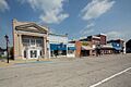
Row of buildings along east side of town square. Owensville Town Hall is on far left.
-
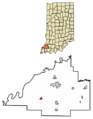
Location of Owensville in Gibson County, Indiana
-
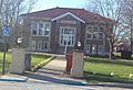
The Owensville Carnegie Library
-

Owensville's uniquely black coated water tower in 2015. Recently been painted gold with the town's Kickapoo logo.
See also
 In Spanish: Owensville (Indiana) para niños
