
Palmwoods-Buderim Tramway facts for kids
Quick facts for kids Palmwoods-Buderim Tramway |
|
|---|---|
.jpg)
Route of the Palmwoods-Buderim Tramway, 2009
|
|
| Location | Telco Road, Buderim, Sunshine Coast Region, Queensland, Australia |
| Design period | 1900 - 1914 (early 20th century) |
| Built | 1914 - 1935 |
| Official name: Palmwoods to Buderim Tramway Track Foundation and Formwork Remnants | |
| Type | state heritage (landscape, built) |
| Designated | 28 July 2000 |
| Reference no. | 601711 |
| Significant period | 1914-1935 (historical) 1914-ongoing (social) |
| Significant components | formation - tramway, trees/plantings, cutting - tramway, culvert - tramway, footings |
| Lua error in Module:Location_map at line 420: attempt to index field 'wikibase' (a nil value). | |
The Palmwoods-Buderim Tramway was a special railway line in Queensland, Australia. It was built between 1914 and 1935. This old tramway is now a heritage-listed site. It is located at Telco Road in Buderim, on the Sunshine Coast Region. The tramway was added to the Queensland Heritage Register on 28 July 2000.
Contents
The Story of the Palmwoods-Buderim Tramway
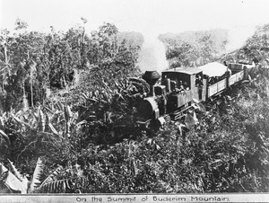
The Palmwoods-Buderim Tramway started running in December 1914. It helped the Buderim area grow a lot, bringing more people and boosting the economy. This tramway was considered "private" and kept running until August 1935. The track was about 12.5 kilometers long. It stretched from the Palmwoods railway station across hilly land to Forest Glen. From there, it climbed all the way to the top of Buderim Mountain.
Why the Tramway Was Needed
In the late 1800s, areas north of Brisbane, now known as the Sunshine Coast, grew quickly. Buderim became a small town for local farmers. Farmers needed to ship their fruit and produce, but it was hard. Shipping by boat from the Mooloolah and Maroochy rivers was tricky because of sandbars and silting. Roads were also very poor, especially the steep ones leading up to Buderim Mountain. It was hard for wagons to get through, especially when it rained.
A government railway line was built from Brisbane to Yandina in 1891, passing through Palmwoods. But getting goods from Buderim to this railway was still a big problem.
Planning and Building the Line
In 1903, the Maroochy Shire Council started thinking about building a tramway to Buderim. There were many ideas about where the tramway should go. Some wanted it to link Buderim to Palmwoods, others to Woombye. There were also talks about connecting to the sugar mill tramway system near Diddillibah.
Finally, in 1911, the council decided to build the Palmwoods-Buderim tramway. They got a government loan of £27,000 to help pay for it. The tramway officially opened on 18 June 1915.
How the Tramway Changed Buderim
Once the tramway was running, Buderim boomed! Fruit production went way up, and land prices increased. The tram was so busy that it often had to make two trips a day.
The tram became super important for everyone in the community. It wasn't just for business.
- Travel for health: Expectant mothers would ride the tram to Palmwoods, then take a train to Nambour. There, they would stay in nursing homes because there were no hospitals nearby.
- Getting around: People from areas like Vise Road would take a horse-drawn gig to Telko Station. From there, they'd ride the tram to Palmwoods to visit Brisbane or Nambour.
- Social life: The tram also took people to sports events and other fun activities.
- Help during tough times: During the Great Depression, people who received "dole" (unemployment money) would use the tram and train to get to Woombye to collect their payments.
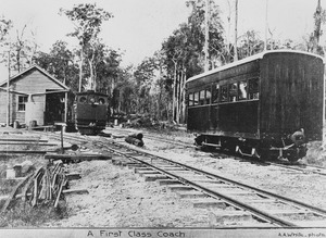
Visitors from Brisbane also used the tram to get to Buderim. The tram usually had about thirteen wagons, one passenger coach, and a guard's van. It was pulled by a German Krauss or American Shay steam engine. The flat wagons had fruit cases in the middle with wooden planks on top, making seats for about 150 passengers!
Why the Tramway Closed
In the 1920s, the tramway started losing money. Farmers were producing less, so there was less freight to carry. Also, new main roads were built, and trucks and cars started competing with the tram.
World War I might have stopped plans to make the tramway bigger or more efficient. There were even ideas to extend the track to Maroochydore, but these plans failed during the economic downturn of the 1930s.
In 1933, the tramway even stopped for a short time because the engine needed repairs, and there wasn't enough money to fix it. The Great Depression made things even worse, and the tramway eventually had to close.
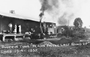
The very last trip of the Buderim tram was on 10 August 1935. Its final job was to help take apart the railway. The rails were sold to the Moreton Sugar Mill Co. and delivered to Palmwoods. The wooden sleepers, bridges, and most buildings were also removed.
How the Tramway Was Built
The Palmwoods-Buderim Tramway was built on some very difficult land. It used a narrow track size (gauge) of 30 inches. This was different from the 42-inch gauge of Queensland Government Rail and the 24-inch gauge of sugar mill trams.
Even though the Maroochy Shire Council owned the tramway, it was considered "private." This is because the council got a government loan, and then 130 local landowners had to pay extra taxes to help pay back the loan. The project cost £34,000, with £21,000 coming from the loan. The loan wasn't fully paid off until 1971, by which time the total paid was £84,000!
Today, the Palmwoods railway station has changed a lot since the tramway closed. Most signs of the old tramway, like the engine shed, are gone.
Remembering the Tramway Today
In 2003, a group called the Buderim-Palmwoods Heritage Tramway Inc. was formed. Their goal is to create a walking track along the old tramway route. They also want to find and restore old tramway items.
What's Left of the Tramway Today
You can still find parts of the Palmwoods-Buderim Tramway today. These include sections of the track's foundation and other structures. You can see them on public land and on some private properties.
Along the Old Track
The tramway track started near the Palmwoods Station car park. It then went north to where the engine shed used to be. From there, it went down to a lower level, crossing Palmwoods Creek. You can still see parts of the embankment (raised ground) where the track used to be.
Further along, the track disappears under houses in some areas. But you can still find parts of the embankment and even a deep ditch called Kelly's Cutting, which is up to 7.5 meters deep.
In other places, the track is overgrown with plants, but you can still see it. Some sections are even used as tracks through private land. You might also spot what looks like an old dam that might have supplied water for the tram.
Crossing Creeks and Farms
Near Eudlo Creek, you can find the remains of old bridges. The track was removed in some areas because of mining, but it appears again further east. It goes through a large strawberry farm, where you can see a clear cutting (a trench dug for the track) with a modern road bridge built over it.
The track then crosses Chevallum Road and the Bruce Highway, leading to where the Forest Glen Station used to be. There have been many changes to the land here, but you can still see signs of the old track.
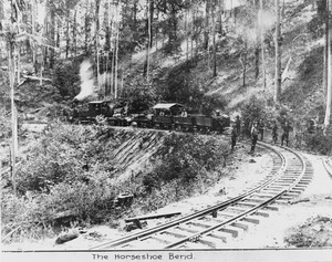
The Climb to Buderim
As the track gets closer to Telco Road, it starts its steady climb to Buderim. This part of the track is very dramatic. You can see:
- Broken cattle grids.
- Collapsed culverts (tunnels for water).
- Deep cuttings, up to eight or nine meters deep, cut through solid sandstone.
- Sharp corners.
- High embankments, sometimes 20 to 30 meters high.
- Beautiful trees, palms, ginger, and orchids growing along the route.
Near Telco Road, the original road bridge is gone, and the track is filled in. You can also find the remains of the White Telko trestle bridge, with only earth banks and a few wooden beams left.
The track continues with more cuttings through sandstone. It crosses another dam wall, goes under a house built on the track, and then crosses Mons Road.
Towards the End of the Line
After Mons Road, the track continues to climb. It becomes a driveway for some houses. You can still see parts of the old stone walls that bordered the track in some places.
Finally, the track disappears as it gets closer to where the Post Office is today. A small sign near the croquet building marks the spot where the original station and post office once stood.
Why the Tramway is Important
The Palmwoods-Buderim Tramway is listed on the Queensland Heritage Register for several reasons:
Showing Queensland's History
The tramway was very important for the development of the region. It helped people and goods move around, showing how Queensland grew over time. It was built to solve problems faced by settlers in the early 1900s. The tramway's story also shows how big events like World War I and the Great Depression affected local projects. The local council owned and ran the tramway for its entire life.
A Unique Part of History
This tramway is special because it had a unique track size of 30 inches. It was also a "private" tramway, meaning it was funded by the local council and landowners, which was uncommon.
Beautiful Scenery
The area where the tramway ran is very beautiful, especially the hilly parts. This makes the tramway site important for its beauty. It's amazing to think how these big changes to the landscape were made using mostly horse power back then! The remaining parts of the track still look good together.
Important to the Community
The tramway has a special connection with the local communities it served. It was a central part of their social and cultural life. It helped people get to sports and cultural events and connected them to bigger towns like Nambour and Brisbane.
