
Maroochydore facts for kids
Quick facts for kids MaroochydoreSunshine Coast, Queensland |
|||||||||||||||
|---|---|---|---|---|---|---|---|---|---|---|---|---|---|---|---|

View of Maroochydore
|
|||||||||||||||

Maroochydore
Location in Queensland
|
|||||||||||||||
| Population | 63,673 (2021 census) | ||||||||||||||
| • Density | 5,053/km2 (13,090/sq mi) | ||||||||||||||
| Postcode(s) | 4558 | ||||||||||||||
| Elevation | 7 m (23 ft) | ||||||||||||||
| Area | 12.6 km2 (4.9 sq mi) | ||||||||||||||
| Time zone | AEST (UTC+10:00) | ||||||||||||||
| Location | |||||||||||||||
| LGA(s) | Sunshine Coast Region | ||||||||||||||
| Region | South East Queensland | ||||||||||||||
| State electorate(s) | Maroochydore | ||||||||||||||
| Federal Division(s) | Fairfax | ||||||||||||||
|
|||||||||||||||
|
|||||||||||||||
Maroochydore (/məˈruːtʃidɔːr/ MƏ-roo-CHEE-dor) is a lively coastal town in the Sunshine Coast Region of Queensland, Australia. It's a popular spot for holidays and a major business hub. In 2021, the urban area of Maroochydore had about 63,673 residents.
The town was first planned in 1903 by Surveyor Thomas O'Connor. Its name comes from the Yuggera language word Muru-kutchi. This word means "red-bill" and refers to the black swan, a bird often seen in the area.
Maroochydore is home to the large Sunshine Plaza shopping centre. It also has the main bus station for local transport services. Many big surf sport events are held here, making it a fun place for sports fans.
Contents
Exploring Maroochydore's Location


Maroochydore is a coastal town with clear boundaries. Its main business area, called the central business district (CBD), is located on Horton Parade.
Maroochy Waters: A Unique Community
Maroochy Waters is a special residential area in Maroochydore. It has waterfront homes right next to the Maroochy River. This area is one of the last canal projects built in Queensland that offers direct access to the river and the Coral Sea. The local council regularly cleans the sand beaches here.
The canals and other structures in Maroochy Waters were built in stages from the late 1970s to the early 1990s. These deep canals help with flood control. The land in Maroochy Waters is also higher than the Maroochydore CBD, which has experienced floods in the past. The main canal is over one kilometre long and was even used as a training ground by Clint Robinson, who won a gold medal in canoeing at the 1992 Olympics.
A Look Back: Maroochydore's History
Maroochydore has grown a lot over the years. The first Post Office opened here on 4 October 1922. Before that, there was a smaller "receiving office" for mail.
Important Buildings and Developments
Our Lady Star of the Sea (Stella Maris) Catholic Church was officially opened in 1950. It was built to replace an older church that was too small. The new church could seat 170 people inside and another 150 on its verandahs. To save money, timber from a recently taken down church in Nambour was used.
The Maroochydore Library opened its doors in 1975, giving residents a place to read and learn.
Horton Park Golf Club was once in Maroochydore. However, it moved to Bli Bli in 2015 and changed its name to Maroochy River Golf Club. This move allowed the Sunshine Coast Regional Council to develop the old golf course area into a brand new city centre called Sunshine Central. This new centre is next to Sunshine Cove, a modern residential and business area. Sunshine Cove even won an award in 2016 for being the best residential property development in Australia.
-

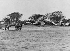
People fishing on the beach in 1907.
-
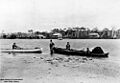
Camping in Maroochydore in 1932.
-

The Cotton Tree Post Office.


Who Lives in Maroochydore?
The population of Maroochydore has been growing. In 2016, the urban area had 56,308 people. By 2021, this number had increased to 63,673 people.
These population numbers include several nearby suburbs. These are places like Coolum Beach, Marcoola, Twin Waters, Alexandra Headland, and Mooloolaba.
Getting Around Maroochydore
Maroochydore has good transport options.
Bus Services
Local bus services are run by Kinetic Group. The main bus stop is located outside the Sunshine Plaza shopping centre. These buses connect Maroochydore to many other towns, including Buderim, Coolum, Kawana Waters, Caloundra, Nambour, and Noosa.
Train and Air Travel
You can reach Maroochydore by train by taking a connecting bus from nearby train stations like Nambour, Woombye, or Landsborough. These stations are on the Nambour & Gympie North Line, which has regular services to Brisbane. There are also coach services from Sunshine Plaza directly to Brisbane Airport.

The Sunshine Coast Airport is just north of Maroochydore. It offers flights to major cities across Australia.
Future Transport Plans
There are plans for new railway lines to improve transport. One idea is to extend the current train line to connect Caloundra, Kawana Waters, and Maroochydore with Brisbane. This line might even go all the way to the Sunshine Coast Airport. Another idea is a light rail system that would start in the Maroochydore CBD and connect to other local areas before ending in Caloundra.
Community and Learning in Maroochydore
Maroochydore offers various facilities for its community.
Local Amenities
The Sunshine Coast Regional Council runs a public library at 44 Sixth Avenue, Cotton Tree. This is a great place for everyone to find books and learn. The Maroochydore branch of the Queensland Country Women's Association also meets here, providing a place for women to connect.
Schools in the Area
Maroochydore has several schools for students of all ages. The main state high school is Maroochydore State High School, which opened in 1964. Other schools in the area include:
- Bli Bli State School (1901)
- Kuluin State School (1987)
- Maroochydore State School (1921)
- Mooloolaba State School (1933)
- Mountain Creek State School (1994)
- Mountain Creek State High School (1995)
- Pacific Paradise State School (1992)
- Immanuel Lutheran College (1982)
- Stella Maris Catholic Primary School (1980)
- Siena Catholic College (1997)
Sports and Recreation in Maroochydore
Maroochydore is a great place for sports! All four main types of football are popular here.
,_Round_5,_2022.jpg)
Major Sports Facilities
The Maroochydore Multi Sports Complex is a big sports ground. It hosts both Australian Rules Football (AFL) and soccer games. It has even held professional AFL Women's matches and AFL pre-season games.
Local Sports Clubs
- The Maroochydore Australian Football Club (nicknamed the Roos) started in 1969. They play in the Queensland Australian Football League (QAFL), which is the top semi-professional league in the state. They also have teams for women and junior players.
- The Maroochydore Soccer Club (known as the Swans) began in 1968. They compete in the Football Queensland Premier League 2 and have women's and junior teams too.
- The Maroochydore Rugby League Club (also called the Swans) was founded in 1972. They play in the Sunshine Coast Gympie Rugby League and have teams for women and juniors.
- The Maroochydore Rugby Union (Swans) started in 1974. They play in the Sunshine Coast Rugby Union competition and have junior teams.
Cricket is also a popular sport in Maroochydore. The Maroochydore Cricket Club plays at Elizabeth Daniels Park.
Images for kids
-
Fish haul, 1907
-

Camping, 1932
-
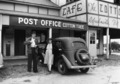
Cotton Tree Post Office
