
Alexandra Headland, Queensland facts for kids
Quick facts for kids Alexandra HeadlandMaroochydore, Queensland |
|||||||||||||||
|---|---|---|---|---|---|---|---|---|---|---|---|---|---|---|---|

Alexandra Headland Beach with Mount Coolum in the background, 2021
|
|||||||||||||||

Alexandra Headland
Location in Queensland
|
|||||||||||||||
| Population | 4,235 (2021 census) | ||||||||||||||
| • Density | 2,650/km2 (6,900/sq mi) | ||||||||||||||
| Postcode(s) | 4572 | ||||||||||||||
| Area | 1.6 km2 (0.6 sq mi) | ||||||||||||||
| Time zone | AEST (UTC+10:00) | ||||||||||||||
| Location | |||||||||||||||
| LGA(s) | Sunshine Coast Region | ||||||||||||||
| County | Canning | ||||||||||||||
| Parish | Mooloolah | ||||||||||||||
| State electorate(s) | Maroochydore | ||||||||||||||
| Federal Division(s) | Fisher | ||||||||||||||
|
|||||||||||||||
Alexandra Headland is a beautiful coastal suburb located in the Sunshine Coast Region of Queensland, Australia. It's part of the larger Maroochydore area. In 2021 census, about 4,235 people called Alexandra Headland home. It's a popular spot for holidays and surfing!
Contents
Where is Alexandra Headland?
Alexandra Headland is nestled right between the main part of Maroochydore and Mooloolaba. It's known for its rocky headland and lovely beaches.
The History of Alexandra Headland
How Alexandra Headland Got Its Name

The rocky point you see today was once called Potts Point. It was named after John Potts, who worked for a timber businessman named William Pettigrew. John Potts lived there from 1880 to 1890. The area was used to move timber between Cotton Tree and the Mooloolah River using strong bullocks.
In 1901, the name was changed to Alexandra Headland. This was done to honor Queen Alexandra, who was the wife of King Edward VII of England.
Early Days and Timber Business
The land was originally part of William Pettigrew's large property, which was about 330 acres. He bought this land in 1864. For the next 30 years, it was a key spot for his timber business. Bullocks would pull logs from Cotton Tree across Potts Point to a timber storage area in Mooloolaba. Pettigrew even built his own house and his overseer's house on the Headland.
Developing a Holiday Spot
In 1903, Thomas O'Connor bought all of Pettigrew's land in both Maroochydore and Mooloolaba. He then divided the land into smaller blocks and started selling them in 1915, especially along the oceanfront.
During the 1920s, many seaside cottages were built on the Headland. These were often built by local families from nearby towns like Woombye and Palmwoods who wanted a place for holidays.
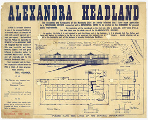

Thomas O'Connor had big plans! In 1916, he wanted to build a large hotel called the Alexandra Residential Hotel. It was built between 1923 and 1928 and opened on December 31, 1928. This was the first big holiday resort on the Maroochy coast. Later, in 1945, the Presbyterian Church bought the hotel. Today, the Uniting Church of Australia runs the site as the Alexandra Park Conference Centre.
As roads and transport improved, Alexandra Headland continued to grow as a popular holiday destination. It became known for its great facilities, including a beach where lifeguards keep swimmers safe.
Who Lives in Alexandra Headland?
In 2021 census, Alexandra Headland had a population of 4,235 people. It's a friendly community with a mix of families and individuals who enjoy the coastal lifestyle.
Schools Near Alexandra Headland
There are no schools directly in Alexandra Headland. However, students can easily go to nearby schools. The closest primary school is Mooloolaba State School. For high school, students can attend Maroochydore State High School or Mountain Creek State High School.
Things to Do in Alexandra Headland
Places to Stay and Meet

- Alexandra Park Conference Centre: Located on Mari Street, this center is run by the Uniting Church of Australia. It has rooms for conferences, places to stay, and food services.
- Alexandra Headland Surf Life Saving Club: This club is on Alexandra Parade. Its amazing members keep the beaches safe by patrolling the surf, rescuing swimmers, and providing first aid. The clubhouse also has a restaurant and bar where you can grab a bite to eat.
Parks and Green Spaces
Alexandra Headland has many beautiful parks where you can relax and enjoy nature:
- Alex Bluff Foreshore Park
- Alex Forest Conservation Area
- Buhk Family Park
- Cooloolathin Park
- Cotton Tree – Alex Foreshore Bushland Conservation Reserve
- Marina Walk
- Nelson Park
- Seaforth Park
- Wilkes Family Park
