Palo, Iowa facts for kids
Quick facts for kids
Palo, Iowa
|
|
|---|---|

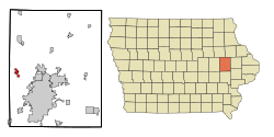
Location of Palo, Iowa
|
|
| Country | |
| State | |
| County | Linn |
| Area | |
| • Total | 1.10 sq mi (2.86 km2) |
| • Land | 1.10 sq mi (2.86 km2) |
| • Water | 0.00 sq mi (0.00 km2) |
| Elevation | 741 ft (226 m) |
| Population
(2020)
|
|
| • Total | 1,407 |
| • Density | 1,275.00/sq mi (492.28/km2) |
| Time zone | UTC-6 (Central (CST)) |
| • Summer (DST) | UTC-5 (CDT) |
| ZIP code |
52324
|
| Area code(s) | 319 |
| FIPS code | 19-61230 |
| GNIS feature ID | 0460004 |
| Website | www.paloia.govoffice2.com |
Palo is a city in Linn County, Iowa, United States. In 2020, about 1,407 people lived there. Palo is part of the larger Cedar Rapids area.
The city is located close to Pleasant Creek State Recreation Park. This park is a great place for outdoor activities.
Contents
History of Palo
The name "Palo" comes from a post office set up in 1849. A person from nearby Marion, Dr. Bardwell, named it after the Battle of Palo Alto. This battle happened during the Mexican-American War.
The town of Palo was officially mapped out in 1854. The very first building in Palo was also built that same year. The town then took its name from the local post office.
The Big Flood of 2008
Palo faced a lot of damage during the big flood in 2008. Almost everyone living in the town, about 980 people, had to leave their homes and businesses. This was a required evacuation ordered by the Linn County Emergency Management. The flood was caused by the Cedar River overflowing its banks.
Geography of Palo
Palo is located at about 42 degrees North and 91 degrees West. This is a way to pinpoint its exact spot on a map.
The United States Census Bureau says that Palo covers an area of about 1.43 square miles (3.7 square kilometers). All of this area is land, meaning there are no large lakes or rivers within the city limits.
People of Palo (Demographics)
| Historical populations | ||
|---|---|---|
| Year | Pop. | ±% |
| 1880 | 135 | — |
| 1910 | 208 | +54.1% |
| 1920 | 224 | +7.7% |
| 1930 | 205 | −8.5% |
| 1940 | 250 | +22.0% |
| 1950 | 285 | +14.0% |
| 1960 | 387 | +35.8% |
| 1970 | 430 | +11.1% |
| 1980 | 529 | +23.0% |
| 1990 | 514 | −2.8% |
| 2000 | 614 | +19.5% |
| 2010 | 1,026 | +67.1% |
| 2020 | 1,407 | +37.1% |
| Source: and Iowa Data Center Source: |
||
Palo's Population in 2020
According to the census in 2020, Palo had 1,407 people living there. There were 482 households, which are groups of people living together.
Most of the people in Palo, about 94%, were White. A small number were Black or African American, Asian, or from two or more races. About 2.1% of the population was Hispanic or Latino.
The average age of people in Palo was 34.3 years old. About 33.4% of the residents were under 20 years old. This means a good portion of the population is made up of kids and teenagers.
Palo's Population in 2010
In the census of 2010, Palo had 1,026 people. There were 358 households in the city. The population density was about 717.5 people per square mile.
Most residents, about 97.6%, were White. A small number were African American, Native American, or Asian. About 1.4% of the population was Hispanic or Latino.
The average age in Palo in 2010 was 32.4 years. About 32.3% of the people were under 18 years old. This shows that Palo has always been a place with many young people.
Education in Palo
Students in Palo attend schools in the Cedar Rapids Community School District.
The schools that Palo students usually go to are:
- Elementary school: Viola Gibson
- Middle school: Harding Middle School
- High school: Kennedy High School
See also
 In Spanish: Palo (Iowa) para niños
 | Kyle Baker |
 | Joseph Yoakum |
 | Laura Wheeler Waring |
 | Henry Ossawa Tanner |

