
Papua (province) facts for kids
Quick facts for kids
Papua
|
|||
|---|---|---|---|
|
|||
| Motto(s):
Karya Swadaya
(Self-Reliance Works) |
|||

Location of Papua in Indonesia
|
|||
| Established | 1 May 1963 | ||
| Capital and largest city |
Jayapura | ||
| Government | |||
| • Body | Provincial Government of Papua | ||
| Area | |||
| • Total | 315,091.62 km2 (121,657.55 sq mi) | ||
| Area rank | 1st in Indonesia | ||
| Highest elevation | 4,884 m (16,024 ft) | ||
| Population
(mid 2019)
|
|||
| • Total | 3,379,302 | ||
| • Rank | 21st in Indonesia | ||
| • Density | 10.7248235/km2 (27.777165/sq mi) | ||
| Health Ministry 2014 Estimate | |||
| Demographics | |||
| • Ethnic groups | Papuan, Melanesian (including Aitinyo, Aefak, Asmat, Agast, Dani, Ayamaru, Mandacan, Mee/Paniai Biak, Serui), Javanese | ||
| • Religion | Christianity (83.15%) Islam (15.88%) Hinduism (0.09%) Buddhism (0.05%) Other (0.82%) |
||
| • Languages | Indonesian (official) 269 indigenous Papuan languages Austronesian languages |
||
| Time zone | UTC+9 (Indonesia Eastern Time) | ||
| ISO 3166 code | ID-PA | ||
| HDI | |||
| HDI rank | 34th in Indonesia (2019) | ||
Papua is the largest and easternmost province of Indonesia. It covers most of Western New Guinea. To its east, it shares a border with the country of Papua New Guinea.
In 2010, a count by Statistics Indonesia showed that Papua had about 2.8 million people. Most of these people are Christians. The province is divided into 28 smaller areas called regencies and one big city. Its capital and largest city is Jayapura.
Contents
Geography and Nature
Papua is a land of amazing natural beauty. It has tall mountains, thick rainforests, and long coastlines. The highest peak in Indonesia, Puncak Jaya, is found here. It is part of the Jayawijaya Mountains.
Diverse Landscapes
The province has many different types of land. You can find snowy peaks, deep valleys, and wide rivers. There are also large areas of swampy land and beautiful beaches. This variety makes Papua a special place for many plants and animals.
Wildlife of Papua
Papua is home to unique animals not found anywhere else. You can see colorful bird-of-paradise birds and tree kangaroos. Many types of wallabies also live here. The dense forests are important habitats for these creatures.
People and Culture
The people of Papua are very diverse. They belong to many different ethnic groups. Each group has its own unique traditions, languages, and ways of life.
Ethnic Groups
Many Papuan peoples and Melanesian groups live in Papua. Some well-known groups include the Asmat, Dani, and Ekari. There are also people from other parts of Indonesia, like the Javanese.
Languages Spoken
While Indonesian is the official language, people in Papua speak many local languages. There are hundreds of different Papuan languages. This makes Papua one of the most linguistically diverse places on Earth.
Traditional Life
Many Papuan communities still follow traditional customs. They live in villages and often rely on farming and hunting. Music and dance are very important parts of their culture. The Tifa drum is a common musical instrument.
Economy and Resources
Papua has rich natural resources. These resources play a big role in its economy.
Mining and Agriculture
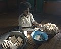
Mining is a very important industry in Papua. The Grasberg mine is one of the largest gold and copper mines in the world. Farming is also key, with many people growing crops like sago. Sago is a starchy food made from the sago palm tree.
Transportation
Getting around Papua can be challenging because of its tough landscape. However, there are important ways to travel. Sentani International Airport in Jayapura is the main airport. The Youtefa Bridge is a modern landmark, helping connect areas near the capital.
History of Papua
Papua has a long and interesting history. It has been known to outside traders for centuries.
Early Mentions
Ancient texts, like the Nagarakretagama, mentioned regions in the east, possibly referring to parts of Papua. European explorers arrived much later. The Dutch set up early trading posts, like Fort Du Bus, in the 1800s.
Becoming Part of Indonesia
After World War II, Papua became part of Indonesia in 1963. This was a significant moment in its history. The province has continued to develop since then.
Images for kids
-
The Nagarakertagama mentioned a region in the east called Wanin, present-day Onin Peninsula in the Fakfak Regency, West Papua
-
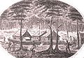
Fort Du Bus, one of the first Dutch administrative and trading post in New Guinea
-
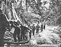
U.S troops landing in Tanahmerah Bay during Operation Reckless, 1944
-
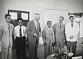
Dutch and Papuan officials during the opening of the Central Hospital in Hollandia, 1959
-
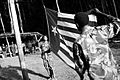
West Papuan separatists raising the Morning-Star flag in the jungles of Papua, 1971
-
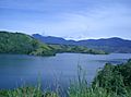
View of Lake Sentani near Jayapura
-
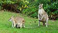
Wallabies are commonly found in New Guinea
-
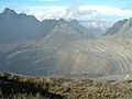
Grasberg Mine in Mimika Regency. Mining is the most important sector in the province
-
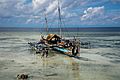
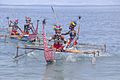
Fishing boats in Biak
-
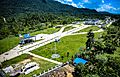
Skouw border checkpoint, on the Indonesia-Papua New Guinea border
-
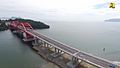
Youtefa Bridge, currently the longest bridge in Papua
-
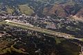
Sentani International Airport in Jayapura is the principal point of entry to Papua
-
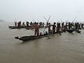
Asmat warriors in dugout canoes reenact a headhunting raid on the Asewet River at Agats
-
Local people from Biak during a ceremony
-
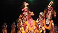
Traditional Papuan war dance from the Yapen Islands
-
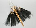
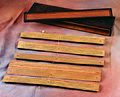
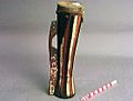
Traditional Papuan dagger
-
Tifa, a Papuan musical instrument
-
Sago is a typical Papuan food, which is usually made into papeda.
-
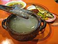
Papeda, a notable dish originating from Eastern Indonesia


.jpg)


See also
 In Spanish: Provincia de Papúa para niños
