Patterson, New York facts for kids
Quick facts for kids
Patterson, New York
|
||
|---|---|---|
| Town of Patterson | ||
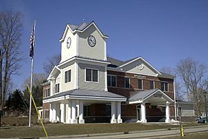
Town Hall
|
||
|
||
| Etymology: after local farmer Mathew Paterson | ||
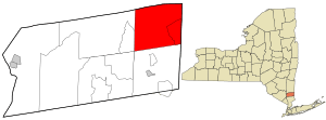
Location of Patterson, New York
|
||
Location of New York in the United States
|
||
| Country | United States | |
| State | New York | |
| County | Putnam | |
| Founded | 1795 | |
| Area | ||
| • Total | 32.90 sq mi (85.22 km2) | |
| • Land | 32.21 sq mi (83.42 km2) | |
| • Water | 0.70 sq mi (1.80 km2) | |
| Highest elevation
(Cranberry Mountain)
|
1,234 ft (376 m) | |
| Lowest elevation | 430 ft (130 m) | |
| Population
(2020)
|
||
| • Total | 11,541 | |
| • Density | 369.75/sq mi (142.76/km2) | |
| Time zone | UTC-5 (EST) | |
| • Summer (DST) | UTC-4 (EDT) | |
| ZIP Code |
12563
|
|
| Area code(s) | 845 | |
| FIPS code | 36-079-56748 | |
| FIPS code | 36-56748 | |
| GNIS feature ID | 0979345 | |
| Wikimedia Commons | Patterson, New York | |
Patterson is a town located in Putnam County, New York, in the United States. It's in the northeastern part of Putnam County. A major highway, Interstate 84, runs through the southwestern part of the town. In 2020, about 11,541 people lived there. Patterson is named after an early farmer named Matthew Paterson. Interestingly, the town's name has two 't's, even though Matthew Paterson sometimes spelled his own last name with just one!
Contents
History of Patterson
The area that is now Patterson was first settled around 1720. This was in a place called The Oblong, which was a strip of land that New York and Connecticut both claimed. The Oblong was about 1.81 miles wide and was given to New York in 1731.
Between 1720 and 1776, many families, mostly from Connecticut, moved into the southern part of The Oblong. They couldn't settle west of it because that land was owned by the Philipse Family. The Philipses had a special grant for most of the land that would later become Putnam County.
Early Settlers and Villages
The Hayt family were among the first settlers in The Oblong, building a house in 1720. Another early settler was Jacob Haviland, who settled in Haviland Hollow in 1731. The first village in Putnam County, the hamlet of Patterson, was originally called Frederickstown. The eastern part of what would become Putnam County was known as Southeast Precinct.
Changes After the Revolution
During the American Revolution, the Philipse family supported the British. Because of this, the state took their land and sold it. In 1788, the Philipse part of The Oblong became the Town of Southeast. The rest of the region became the Town of Fredericktown in Dutchess County, New York.
In 1795, Fredericktown was divided into four new areas:
- The Town of Carmel.
- A part that joined with the northern half of Southeast to become the Town of Franklin. This town was later renamed the Town of Patterson in 1808.
- A part that joined with the southern half of Southeast to become a new, larger Town of Southeast.
- The remaining part of the town, which was called the Town of Frederick for a while. It was renamed the Town of Kent in 1817.
Famous People from Patterson
Patterson has been home to some interesting people:
- Henry Ludington – A local resident and the father of Sybil Ludington.
- Sybil Ludington – A local hero from the Revolutionary War.
- Elizabeth Montgomery – An actress who spent her childhood summers in Patterson. She continued to live there during summer seasons until she passed away in 1995.
- Pete Seeger – A well-known musician.
- Martha-Bryan Allen – A Broadway actress and Elizabeth Montgomery's aunt. She owned a summer home in Patterson, which later became part of Wonder Lake State Park.
Geography of Patterson
Patterson covers a total area of about 32.9 square miles (85.22 square kilometers). Most of this is land, with about 32.3 square miles (83.42 square kilometers) of land and 0.6 square miles (1.80 square kilometers) of water.
The northern border of Patterson touches Dutchess County, New York. The eastern border of the town is also the border with Connecticut.
Population and People
As of the census in 2000, there were 11,306 people living in Patterson. The population density was about 350 people per square mile. There were 3,529 households, and 2,678 of these were families.
About 41.3% of households had children under 18 living with them. Most households (63.0%) were married couples. About 9.6% had a female head of household without a husband present.
The average household had 2.86 people, and the average family had 3.29 people.
The population was spread out by age:
- 26.7% were under 18 years old.
- 7.0% were between 18 and 24.
- 36.8% were between 25 and 44.
- 22.9% were between 45 and 64.
- 6.7% were 65 years or older.
The average age in Patterson was 36 years. For every 100 females, there were about 106 males.
The median income for a household in the town was $66,250. For families, the median income was $75,746. The average income per person in the town was $26,103. About 4.9% of the population lived below the poverty line.
Getting Around Patterson
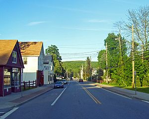
Two main roads run through Patterson: New York State Route 22 and State Route 311. Route 22 goes through all the towns on the east side of Putnam County and passes right through Patterson's business area.
I-84 is a major highway that goes through the southwestern part of Patterson. It has an exit (Exit 61) for Route 311.
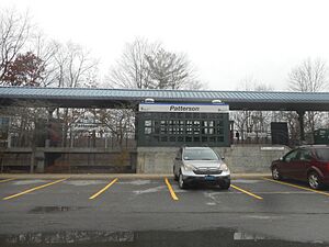
For those who travel to New York City, the Metro-North Railroad offers train service. The Patterson train station is located in the center of town on the Harlem Line.
Places and Communities in Patterson
Patterson has several smaller communities and interesting spots:
- Barnum Corners – A small community west of Putnam Lake.
- Camp Brady – A location in the western part of the town.
- Cascade Farm and Farm School Inc. – A small farm that supports the community, located on Harmony Road.
- Fields Corners – A community in the southwestern part of the town.
- Haines Corners – A community southwest of Haviland Hollow.
- Haviland Hollow – A community northwest of Putnam Lake.
- Patterson – The main community in the northern section of the town.
- Putnam Lake – A community west of the lake also called Putnam Lake. This lake is in the eastern part of the town, near the Connecticut border.
- Steinbeck Corners – A community in the southern part of the town.
- Thunder Ridge – A ski area located north of Putnam Lake.
- West Patterson – A community west of the main Patterson hamlet.
- Haviland Hollow Farm – A place for polo and horse riding. It's built on the historic Colonial River Farm.
- Watchtower Educational Center (Watchtower Bible School of Gilead) – A religious school and office complex run by Jehovah's Witnesses. Many visitors come here each year for tours and educational programs.
- Wonder Lake State Park – A large state park (over 1100 acres) on the western side of the town, near Interstate 84.
See also
 In Spanish: Patterson (Nueva York) para niños
 | Victor J. Glover |
 | Yvonne Cagle |
 | Jeanette Epps |
 | Bernard A. Harris Jr. |


