
Pechora (river) facts for kids
Quick facts for kids Pechora |
|
|---|---|
 |
|

Pechora catchment area and tributaries
|
|
| Other name(s) | Russian: Печо́ра; Komi: Печӧра; Nenets: Санэроˮ яха |
| Country | Russia |
| State | Komi Republic, Nenets Autonomous Okrug |
| Cities | Naryan-Mar, Pechora, Ust-Tsilma |
| Physical characteristics | |
| Main source | Ural Mountains Russia 630 m (2,070 ft) 62°12′N 59°26′E / 62.200°N 59.433°E |
| River mouth | Arctic Ocean, Pechora Sea / Barents Sea 0 ft (0 m) 68°18′N 54°25′E / 68.300°N 54.417°E |
| Length | 1,809 km (1,124 mi) |
| Basin features | |
| Basin size | 322,000 km2 (124,000 sq mi) |
| Tributaries |
|
The Pechora (Russian: Печо́ра; Komi: Печӧра; Nenets: Санэроˮ яха) is a very long river in Europe. It is actually the sixth-longest river on the continent! The Pechora flows from Northwest Russia all the way to the Arctic Ocean. Most of the river is in the Komi Republic, but its northern part crosses the Nenets Autonomous Okrug.
Contents
Pechora River Facts

The Pechora River is about 1,809 kilometres (1,124 mi) long. That's a bit shorter than the Columbia River in North America. The area of land that drains into the Pechora, called its basin, is huge. It covers about 322,000 square kilometres (124,000 sq mi), which is roughly the same size as the country of Finland!
When we look at how much water flows through it each year, the Pechora is the third biggest river in Europe. Only the Volga and Danube rivers carry more water. The Pechora carries about half as much water as the Danube. It carries more water than its nearby "sister" river, the Northern Dvina.
What's special about the Pechora is that it's the largest river outside of New Guinea that doesn't have any dams built on it. This means its natural flow is still untouched.
Pechora River Surroundings
To the west of the Pechora's lower part, you'll find the Timan Ridge. To the east, along the side of the Ural Mountains, is the Yugyd Va National Park. This park is home to the Virgin Komi Forests, which are the largest untouched forests in Europe. Imagine forests that have never been cut down by people!
In the far northeast of the river basin, along the Usa River, there's a big coal mining area called Vorkuta. Long ago, the Pechora River was a very important way to travel. People used it to reach northwest Siberia. Today, a railway connects Vorkuta to Moscow.
River's Journey
The Pechora River starts high up in the Ural Mountains. This is in the southeastern part of the Komi Republic. This area is a protected place called the Pechora-Ilych Nature Reserve. On the other side of the Ural Mountains, other rivers like the Northern Sosva begin.
The Pechora first flows south, then west. It then turns north near a place called Yaksha. This is where small boats can start sailing on the river. In the past, people would carry their boats and goods over land from here to reach the Kama basin.
The river continues its journey:
- It flows past Komsomolsk-na-Pechore.
- It reaches Ust-Ilych, where the Ilych river joins it from the east.
- It then heads northwest to Troitsko-Pechorsk, which is about 1,359 kilometres (844 mi) from its mouth.
- Next, it flows north to Vuktyl and Ust-Shchuger, where the Shchugor river joins from the east.
- The river keeps flowing north to the town of Pechora. This is where the railway from Vorkuta crosses the river.
- Further north, it reaches Ust-Usa. Here, the Usa river joins from the east. The Usa was once a key route for travelers heading into Siberia.
The Pechora then makes a big curve, flowing northwest, then west, and finally southwest. The Izhma river joins it from the south. It flows even further west to Ust-Tsilma, which is about 425 kilometres (264 mi) from its mouth. Here, two more rivers join: the Pizhma from the southwest and the Tsilma from the west. Before modern roads, people would travel up the Tsilma and then carry their boats to the Pyoza river to reach the White Sea.
Finally, the Pechora turns north again. It crosses the Arctic Circle and the border into the Nenets Okrug. It passes by Pustozyorsk and Naryan-Mar. Naryan-Mar is the capital of the Nenets region and a port at the start of the Pechora's wide delta. The river then flows into Pechora Bay, then the Pechora Sea, and finally empties into the Barents Sea, which is part of the Arctic Ocean.
River Flow and Water Levels
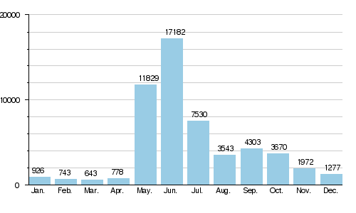
Scientists have measured the average amount of water flowing in the Pechora River each month. This was done between 1981 and 1993 in a village called Oksino. This village is about 141 km (88 mi) upstream from where the river meets the sea.
The diagram below shows how much water flows in the river during different months. You can see that the river carries much more water in May and June. This is when the snow and ice from winter melt, causing the river to swell. In the colder months, like March, the water flow is much lower.
Canal Projects and History
Before railways became common, people often traveled to the Pechora region using a special route. They would use a portage road. This meant carrying their boats and goods over land from Cherdyn in the Kama river basin to Yaksha on the Pechora.
Later, in the 1960s to 1980s, there was a lot of talk about building a Pechora–Kama Canal. This canal would follow a similar path. The main idea wasn't just for transportation this time. It was part of a bigger plan to move some of the Pechora's water to the Kama River. This was called the Northern river reversal scheme. However, no major construction for this canal ever happened. The only significant event on the proposed route was a very large test blast in 1971. This blast created a crater over 600 metres (2,000 ft) long!
See also
 In Spanish: Río Pechora para niños
