Northern Dvina facts for kids
Quick facts for kids Northern Dvina |
|
|---|---|
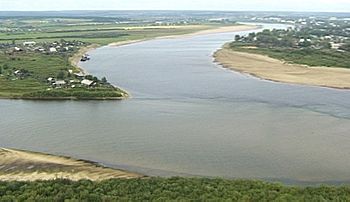
Northern Dvina starts as the confluence of Yug River (on left) and Sukhona River (on top) near Veliky Ustyug (photo 2001)
|
|
| Country | Russia |
| Physical characteristics | |
| Main source | Confluence of Yug and Sukhona |
| River mouth | Dvina Bay 0 m (0 ft) |
| Length | 744 km (462 mi) |
| Basin features | |
| Basin size | 357,052 square kilometres (137,859 sq mi) |
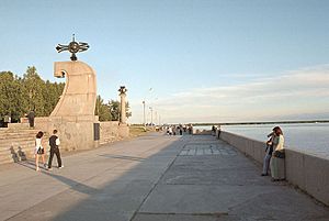
The Northern Dvina (Russian: Се́верная Двина́) is a big river in northern Russia. It flows through two regions, Vologda Oblast and Arkhangelsk Oblast. Finally, it empties into the Dvina Bay of the White Sea.
This river, along with the Pechora River to its east, helps drain much of Northwest Russia. Its waters eventually reach the Arctic Ocean. It is important not to confuse it with the Western Dvina river.
The main rivers that flow into the Northern Dvina are the Vychegda (from the right), the Vaga (from the left), and the Pinega (from the right).
Contents
What's in a Name? The River's Etymology
The name of the Northern Dvina river is thought to come from the Western Dvina river. The word "Dvina" itself does not come from a Uralic language. Its exact origin is not fully clear. However, it might be an ancient Indo-European word. This word probably meant "river" or "stream."
In the Komi language, people call the river Вы́нва (Výnva). This name combines two words: vyn meaning "power" and va meaning "water" or "river." So, Výnva means "powerful river."
Geography of the Northern Dvina
River Basin: Size and Location
The Northern Dvina river is 744 kilometres (462 mi) long. If you include its main starting river, the Sukhona, the total length becomes 1,302 kilometres (809 mi). This is about as long as the Rhine river in central Europe!
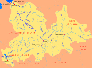
The area that collects water for the Northern Dvina is huge. It covers 357,052 square kilometres (137,859 sq mi). This river basin includes most of the Vologda and Arkhangelsk Oblast regions. It also covers parts of the Komi Republic and Kirov Oblast. Some smaller areas in Yaroslavl and Kostroma Oblast are also part of it.
Many important cities and towns are located in this river basin. These include Arkhangelsk and Vologda. There are also historic towns like Veliky Ustyug, Totma, Solvychegodsk, and Kholmogory.
The Northern Dvina basin looks a bit like a "T" shape. The Sukhona River flows east for 558 kilometres (347 mi). It then joins the Vychegda river basin. The Vychegda flows west and is 1,130 kilometres (700 mi) long. The combined river then flows northwest. It reaches the White Sea near the city of Arkhangelsk.
Let's look closer at how the rivers meet. The Sukhona river flows east. It meets the Yug River, which flows north, at Veliky Ustyug. From this meeting point, the river is called the Northern Dvina. It flows north for about 60 km. Then, at Kotlas, it meets the Vychegda River, which flows from the west. After this, the Northern Dvina turns northwest. It then flows into the White Sea.
In the past, the Sukhona-Vychegda route was important for travel from east to west. The Northern Dvina-Yug route was used for north-south travel. Today, the upper Sukhona river is connected to the Volga–Baltic Waterway. This waterway links Petersburg to Moscow.
River's Path: From Start to Sea
The Sukhona river flows east, then northeast. It joins the Yug river at Veliky Ustyug. At this point, it becomes the Northern Dvina. A highway, the P157, connects Kostroma with Kotlas. It passes through Nikolsk and Veliky Ustyug. North of Veliky Ustyug, the highway runs along the left bank of the Northern Dvina.
The river flows about 60 kilometres (37 mi) north. It crosses from the Vologda Oblast into the Arkhangelsk Oblast. In the city of Kotlas, it meets the Vychegda River. The Vychegda flows from the west and starts in the northern Ural Mountains.
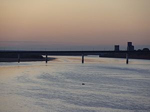
The Vychegda river is actually longer than the Northern Dvina at their meeting point. Because of this, the part of the Northern Dvina before it meets the Vychegda is sometimes called the Lesser Northern Dvina (Russian: Малая Северная Двина). A bit downstream from this meeting, a railway crosses the Northern Dvina. This railway connects Konosha with Kotlas and Vorkuta.
The Northern Dvina then turns northwest. It receives water from several smaller rivers. These include the Uftyuga and the Nizhnyaya Toyma. Both of these flow in from the northeast. Near the town of Bereznik, the Vaga river joins from the south. The M8 highway, which goes from Moscow to Arkhangelsk, also enters the region here. The Yemtsa river joins from the southeast. The P1 highway, from Kargopol, runs alongside it.
The Pinega river, once an important travel route, joins from the east. Near where the Pinega meets, the Northern Dvina splits into several smaller channels. One of these channels passes by the old village of Kholmogory. This village is about 75 kilometres (47 mi) southeast of Arkhangelsk. The channels then rejoin. They flow past the modern logging town of Novodvinsk.
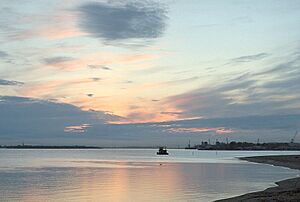
Downstream from Novodvinsk, the river forms a large delta. This delta covers about 900 square kilometres (350 sq mi). The big port city of Arkhangelsk is located in the upper part of this delta. Arkhangelsk slowly became more important than Kholmogory as the main city in the region. On the southwest side of the delta is Severodvinsk. This is a naval base and the second-largest city in the region. The delta finally ends in the Dvina Bay of the White Sea.
The river flows through several districts. These include Velikoustyugsky District in Vologda Oblast. In Arkhangelsk Oblast, it flows through Kotlassky, Krasnsoborky, Verkhnetoyemsky, Vinogradovsky, Kholmogorsky, and Primorsky districts. The main towns of all these districts are on the banks of the Northern Dvina. This is because the river used to be the most important way to travel and transport goods in the region.
During summer, the entire Northern Dvina river is open for boats. It is used a lot for timber rafting, which is floating logs down the river. The Northern Dvina Canal connects this river with the larger Volga–Baltic Waterway.
In the 1800s, there was a short-lived canal called the Northern Ekaterininsky Canal. This canal connected the Northern Dvina basin with the Kama basin. However, it is now abandoned. From 1926 to 1928, a canal was built. It connected the Pinega river, a main tributary of the Northern Dvina, with the Kuloy river. But this canal is also mostly unused today.
Most commercial passenger boat trips have stopped. Only local passenger lines still operate. For example, the passenger line that connected Kotlas and Arkhangelsk stopped running in 2005.
A Look Back: History of the Northern Dvina
The area around the Northern Dvina was first home to Finnic peoples. Later, people from the Novgorod Republic settled there. The only exception was Veliky Ustyug, which was part of the Vladimir-Suzdal Principality. Novgorod controlled the rest of the Northern Dvina basin.
Veliky Ustyug was first mentioned in old records in 1207. Shenkursk was mentioned in 1229, and Solvychegodsk was founded in the 1300s. By the 1200s, merchants from Novgorod had already reached the White Sea. The region was first popular because of its fur trade.
The main water route from Novgorod to the Northern Dvina was long. It went along the Volga river and its tributary, the Sheksna. Then, boats went along the Slavyanka River into Lake Nikolskoye. From there, boats were carried over land to Lake Blagoveshchenskoye. Finally, they went downstream along the Porozovitsa River into Lake Kubenskoye, and then to the Sukhona and the Northern Dvina.
From the Northern Dvina, there were several ways to reach the basin of the Mezen. From the Mezen, merchants could even reach the basins of the Pechora and the Ob. These routes involved going upstream on different rivers and then carrying boats over land for short distances. For example, one route went up the Vychegda and Yarenga rivers, then by land to the Vashka.
From the 1300s, Kholmogory was the main trading port on the Northern Dvina. But in the 1600s, Arkhangelsk took its place. Until the 1700s, Arkhangelsk was the main port for trade between Russia and western Europe by sea. The Northern Dvina was the most important trade route connecting central Russia with Arkhangelsk.
Peter the Great changed this situation a lot. In 1703, he founded Saint-Petersburg. This opened up trade through the Baltic Sea. He also built a highway between Saint-Petersburg and Arkhangelsk through Kargopol. The river quickly lost its role as the main trade route. This change sped up even more when a railway was built between Vologda and Arkhangelsk from 1894 to 1897.
The Northern Dvina was also the site of several battles during the Russian Civil War. Many of these battles involved the Allied forces. They were part of their North Russia Campaign. A special group of boats, called the Northern Dvina Flotilla, was used during the Civil War.
See also
 In Spanish: Dviná Septentrional para niños
 | Claudette Colvin |
 | Myrlie Evers-Williams |
 | Alberta Odell Jones |


