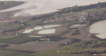
Penna, Tasmania facts for kids
Quick facts for kids PennaHobart, Tasmania |
|||||||||||||||
|---|---|---|---|---|---|---|---|---|---|---|---|---|---|---|---|

Aerial view
|
|||||||||||||||
| Population | 422 (2016 census) | ||||||||||||||
| Postcode(s) | 7171 | ||||||||||||||
| Location | 5 km (3 mi) NW of Sorell | ||||||||||||||
| LGA(s) | Sorell | ||||||||||||||
| Region | South-east | ||||||||||||||
| State electorate(s) | Lyons | ||||||||||||||
| Federal Division(s) | Lyons | ||||||||||||||
|
|||||||||||||||
Penna is a quiet area where people live in Tasmania, Australia. It's part of the Sorell Council region. Penna is located about 5 kilometers (about 3 miles) north-west of the town of Sorell. In 2016, a count showed that 422 people lived in Penna.
What's the Story Behind Penna?
The name "Penna" probably came from an old farm nearby called "Pennar." Some people also think the name might be an Aboriginal word. It could mean "man" or "man and wife." Penna officially became a recognized place in 1972. There used to be a post office in the area. It opened in 1914 and was first called Frogmore Post Office. The next month, its name changed to "Penna." This post office closed down in 1955.
Where is Penna Located?
Penna is next to a body of water called Pitt Water. This water is an inlet, which means it's a narrow part of the sea that reaches inland. Pitt Water is connected to a larger bay called Frederick Henry Bay. It forms the border on the south-west side of Penna. It also makes up parts of its western and south-eastern edges.
How Do People Travel in Penna?
A main road, called Route C351 or Brinktop Road, goes through Penna. It enters the area from the north-west. The road then continues all the way to the east, where it leaves Penna. This road helps people get around the area easily.
 | James Van Der Zee |
 | Alma Thomas |
 | Ellis Wilson |
 | Margaret Taylor-Burroughs |


