Perranzabuloe facts for kids
Quick facts for kids Perranzabuloe
|
|
|---|---|
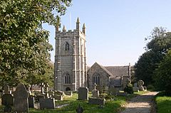
 Perranzabuloe parish church |
|
| Lua error in Module:Location_map at line 530: Unable to find the specified location map definition: "Module:Location map/data/Cornwall (mainland)" does not exist. | |
| Population | 5,406 (Civil Parish, 2011 including Barkla Shop , Callestick and Goonhavern) |
| OS grid reference | SW 770,520 |
| Civil parish |
|
| Unitary authority | |
| Ceremonial county | |
| Region | |
| Country | England |
| Sovereign state | United Kingdom |
| Post town | TRURO |
| Postcode district | TR4 |
| Dialling code | 01872 |
| Police | Devon and Cornwall |
| Fire | Cornwall |
| Ambulance | South Western |
| EU Parliament | South West England |
| UK Parliament |
|
Perranzabuloe (pronounced per-ran-ZAB-yoo-loh) is a coastal area in Cornwall, England. It's a "civil parish," which is like a local government area. The name comes from old Latin, meaning "Piran in the sand." This refers to Saint Piran, who is the patron saint of Cornwall. He built a small church here a very long time ago.
Perranzabuloe is located on the Atlantic coast. It's next to other places like St Agnes and Cubert. The main village in the area is Perranporth, which is about 2 kilometers (just over a mile) north of the hamlet of Perranzabuloe. Other small settlements nearby include Goonhavern and Callestick. In 2011, about 5,486 people lived in the parish.
Contents
Discovering St Piran's History
The name Perranzabuloe comes from "Piran in the sand." This is because Saint Piran, the patron saint of Cornwall, is said to have landed here from Ireland in the 7th century. He built a small chapel, called an "oratory," near the coast. Long ago, Perranzabuloe was a special church area connected to Exeter Cathedral. It even had control over the church in St Agnes until 1846, when St Agnes became its own separate church area.
St Piran's Round: An Ancient Outdoor Theatre
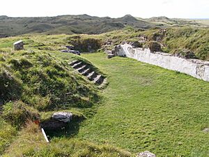
St Piran's Round is a very old circular area with defenses. It was built a long time ago, even before recorded history. Later, people used it as a "plen-an-gwary." This was an outdoor theatre or playing area where plays, especially religious ones, were performed. It's one of only two such places still remaining.
The Churches of Perranzabuloe
Perranzabuloe has a fascinating history of churches, especially because of the moving sands.
St Piran's Oratory: The First Church
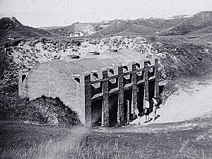
The very first church, St Piran's Oratory, was built in the sand dunes called Penhale Sands. Legend says St Piran built it after arriving from Ireland. When it was found in 1835, it was in good shape, only missing its roof. However, it was damaged by people and later attempts to protect it.
This small stone church was about 9 meters (30 feet) long. Inside, it was very simple. There was a small opening above a stone altar where a skeleton, believed to be St Piran's, was found. Some carved stone "Celtic" heads that were once part of the entrance arch are now kept safe in the Royal Cornwall Museum.
The inside of the oratory was quite dark, with only two tiny openings for light. It's thought the roof might have been made of stone, like other ancient churches in places like Ireland.
Local groups started a project in 2014 to re-dig and learn more about this important site.
The Sand's Impact: Moving Churches
Over time, the sand started to cover the oratory. Because of this, the oratory was left empty in the 10th century. A writer from the 1600s, Richard Carew, wrote about how the sand kept covering the land.
When the oratory was abandoned, a new church was built nearby. This is now known as St Piran's Old Church. People thought a stream would protect it from the sand, and it did for many years. This church was finished by the 12th century and made bigger in 1462.
However, tin mining in the area caused the stream to dry up. Eventually, the sand dunes swallowed the old church too. The last church service there was in 1795. Parts of the church were taken down, and the stones were used to build a new church further inland. The old church's graveyard was used until 1835 before it was also covered by sand.
The oratory site was dug up in 1910, but the stone building is now buried in the sand again. The site of St Piran's Old Church and a 10th-century cross next to it were also excavated in 1919.
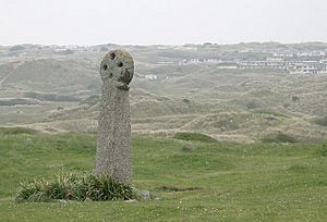
St Piran's Cross, which is thought to be the oldest stone cross in Cornwall, stands in the dunes. It's dedicated to tin miners and is about 2.4 meters (8 feet) tall.
Long ago, there was also a monastery called Lanpiran near the oratory. The special items belonging to St Piran were kept in St Piran's Old Church. This made it a popular place for people to visit on pilgrimages.
The Current Parish Church
The church used today is in Perranzabuloe hamlet. It was officially opened in July 1805. Many of its stones and materials came from St Piran's Old Church.
This church has a main area (nave), a special area for the altar (chancel), and side sections (aisles and transepts). One of the aisles is called the Chyverton aisle. The church tower has three levels, a decorated top, and three bells. In 1878, the church was reopened after being updated with new seats and a new roof for the chancel.
Celebrating St Piran's Day
St Piran's Day is celebrated every year on March 5th. The biggest event in Perranzabuloe is a march across the sand dunes to St Piran's Cross. Thousands of people attend, often wearing black, white, and gold, which are the colors of Cornwall. They also carry the Saint Piran's Flag, which is the flag of Cornwall.
In recent years, a play about the life of St Piran, spoken in the Cornish language, has been performed at this event. People also carry daffodils and place them at the cross.
In October each year, Perranporth hosts a festival called 'Lowender Peran'. This is an 'inter-Celtic' festival, meaning it celebrates the cultures of Celtic nations. It is also named in honor of St Piran.
Perran Feast is another traditional celebration in Perranzabuloe Parish. It happens on the last Monday in October. On the Sunday before, both the local Old Cornwall Society and the Anglican Church remember St Piran. There's a walk to the site of St Piran's Oratory in the afternoon and a church service in the evening.
Chiverton: A Mining History
Southwest of Zelah, but still in Perranzabuloe parish, is Chyverton House. Near it was an important lead mine called West Chiverton Mine. Between 1859 and 1886, this mine produced a huge amount of lead ore – 45,100 tons! There were also seven other mines in the area with "Chiverton" in their names, though they were less successful.
West Chiverton Mine was very large. In 1870, it had 1000 workers, and its main shaft went down over 213 meters (700 feet). The mine closed in 1886.
There was once a well called St Piran's well at Perranwell. It was believed to help cure a bone disease called rickets. The well was taken down before 1925, and its stones were moved to Chiverton.
Notable People from Perranzabuloe
- Ralph Dunstan: A musician who is buried in the churchyard.
- Donald Healey: A famous rally driver, car engineer, and speed record holder. He was born in this parish.
- May Brothers: Frederick and Alfred May were engineers who worked in South Australia.
 | Jackie Robinson |
 | Jack Johnson |
 | Althea Gibson |
 | Arthur Ashe |
 | Muhammad Ali |


