
Peterhead Bay facts for kids
Quick facts for kids Peterhead Bay |
|
|---|---|

Peterhead Bay coast showing the town in the distance.
|
|

Peterhead Bay
Location in Aberdeen
|
|
| Location | Buchan, Aberdeenshire Scotland |
| Coordinates | 57°29′57.9660″N 1°46′57.2376″W / 57.499435000°N 1.782566000°W |
| Ocean/sea sources | North Sea |
| Basin countries | Scotland |
| Max. length | 6.43738 km (4.00000 mi) |
| Max. width | 4.82803 km (3.00000 mi) |
| Average depth | 20 metres (66 ft) |
Peterhead Bay is a large bay on the coast of Scotland. It is located near the town of Peterhead in Aberdeenshire. This area is the most eastern point in mainland Scotland.
The bay is a big natural harbor. It has been made even better with large walls called breakwaters. These walls help protect the harbor, turning it into a busy port and marina. The Port of Peterhead now owns and manages it.
A long time ago, on December 25, 1715, an important person named James Francis Edward Stuart landed here. He was known as the "Old Pretender." He stayed in a house in the town and met with his friends.
Contents
History of Peterhead Bay
Peterhead Bay has a long and interesting history. People have been building and improving its harbors for centuries.
Early Harbor Building
In 1593, work began on Peterhead's very first harbor, called Port Henry. This was the start of Peterhead becoming an important port.
Keith Inch Island
Keith Inch used to be a separate island in the bay. Water flowed between it and the mainland. There was even a fishing village on the island before Peterhead town existed. In 1739, a lot of soil and rocks were used to connect the island to the mainland.
A castle was built on the south side of Keith Inch in the 1500s. There was also a small fort with cannons. These cannons came from a Spanish ship called the St Michael. This ship was part of the Spanish Armada and sank near the bay. Later, more batteries (places for cannons) were built to protect the harbor.
Building the Harbors
In 1773, a civil engineer named John Smeaton helped build the south harbor. It was first called Sackit-hive.
Later, in 1808, another engineer, William Wallace, was chosen to build the north harbor. He worked to make the harbor deeper and build a new quay wall. This was a big job, as they had to remove a lot of rock. The harbor was made 6 feet deeper, and a long embankment was built. This project cost a lot of money, but it greatly improved the port.
More recently, new deep-water harbors have been built. In 2010, construction started on Smith Quay. In 2015, a large project began to build a new, modern fish market and improve the inner harbor.
Pirate Attacks
During the 1600s and 1700s, ships in Peterhead Bay and the town itself were sometimes attacked by pirates.
French Privateer Attack
In 1688, during a war, a French privateer ship with 24 guns attacked the harbor and town. It caused a lot of damage. The privateer also stole sheep and cattle from the town. Peterhead didn't have much gunpowder at the time. So, only two cannons in the fort could be fired to stop the privateer from landing.
Chasing Away Attackers
Later, a privateer chased a ship into the bay. The people of Peterhead helped by firing small guns, forcing the privateer to leave. A similar event happened when an English ship was chased into the harbor. The townspeople and the fort's cannons helped drive the attacker away.
Another time, two privateers tried to send small boats to attack the town. But the fort's cannons fired at them, making them retreat. A ship from Leith, heading to Norway, also found safety in the bay when another privateer attacked it. The cannons were used effectively to make the privateer sail away.
Daniel Fall's Attack
In the 1780s, a famous English pirate named Daniel Fall often bothered ships in the bay. One day, Captain Alex Taylor's ship was attacked by Fall. Cannons from the south battery were fired, forcing Fall's ship to move out of range.
That night, Fall's crew tried to attack ships in the harbor with a small boat. They fired at the guards on the pier, but the guards fired back, making them leave. The next day, the townspeople loaded their biggest cannon with extra gunpowder. They fired at Fall's ship, damaging it and forcing it to leave for good. This was confirmed by a Peterhead man who was being held for ransom on Fall's ship.
Protecting Ships
In 1704, when Admiral Baron de Pointis attacked and burned Dutch ships along the east coast, over 100 vessels found safety in Peterhead Bay. The fort's guns protected them. During wars, ships were often saved by fleeing to the bay.
Ship Building in Peterhead Bay
People have been building ships in Peterhead Bay since the early 1600s. Ships were built for trading with places like India, America, the Baltic Sea, and the Mediterranean. Businesses that made ropes and nails were also in Peterhead to support the shipbuilding industry.
In the 1600s, many ships were built for whaling in Greenland. A whaling ship could cost a lot of money to prepare. It would have several small boats and many men with special tools for catching whales. Ships were also built for fishing cod and other fish near Norway and Spain. Later, ships were built to export fish, butter, cheese, grain, and even granite. Coal and iron were brought in by ship.
Whaling and Fishing
In the mid-1500s, Keith Inch island in the bay was a meeting place for Dutch fishermen. They came to catch cod and ling.
The Whaling Era
Peterhead Bay was a major whaling port between 1788 and 1893. By 1840, more than half of Britain's whaling ships sailed from Peterhead.
David Gray Jr was a very successful whaling captain from Peterhead. He started working at age 14, going on trips to the whaling grounds in Greenland. Over 43 whaling seasons, he caught 197 whales and 168,000 seals. He became known as the Prince of Whalers.
David Gray Jr was also interested in animals. He studied Arctic biology and wrote about whale behavior. He estimated that Peterhead whalers had caught 4,195 whales between 1788 and 1879.
Modern Fishing
Today, Peterhead harbor is still very important for fishing. It has a large fleet that catches whitefish. It is the biggest whitefish port in Britain.
Oil and Gas Industry
Peterhead Bay and its harbor became a major port for the oil and gas industry in 1973. This happened because the harbor is deep and close to the oil fields in the North Sea.
Special laws had to be changed to allow for oil and gas development in the harbor. Work began in 1972 to make the harbor areas even deeper. By 1973, a lot of money was invested to improve the harbor and build a gas and oil terminal. Oil and gas from the North Sea now flow through Peterhead Bay.
Geography of the Bay
Just south of Peterhead Bay is Sandford Bay. On the north side of the harbor is the former island of Keith Inch. This is where the north breakwater is connected. Further north are the South Head rocks, which form the easternmost point of land. From there, the land curves northwest to the North Head rock. A small stream called Almanythie Creek flows into the North Sea at that point.
Marina and Harbor Facilities
The port of Peterhead has two main areas. These are Peterhead Bay Harbor and the Harbors of Peterhead. Peterhead Bay Harbor is the deep-water area used mainly for the oil and gas industry. The Harbors of Peterhead serve the fishing and cargo industries.
The harbor is protected by two huge breakwaters. These walls enclose about 300 acres of water in Peterhead Bay. The south breakwater is about 2,700 feet long. It was built between 1892 and 1912 with help from people from the prison at HM Prison Peterhead. The north breakwater is about 1,500 feet long and was built from 1912 to 1956. It is made of granite and is very wide and deep. Very large ships can use the breakwater.
Here are some of the different areas within Peterhead Bay's harbor facilities:
| Port and Harbor Areas | What They Are Used For |
|---|---|
| Smith Embankment | This is a large, deep-water dock called the Smith Quay. It was added to the North harbor for big ships that need to load or unload large amounts of cargo. This includes equipment for underwater projects, renewable energy, and other large items. It is 200 meters long and has a crane that can lift 500 tonnes. |
| South Base | This area helps ships quickly load and unload for the North Sea oil and gas industry. It is used by support ships for oil platforms, tankers, and ships that carry large amounts of goods. |
| North Base | The North Base includes the breakwater and the North Base Jetty. The jetty is a concrete pier with two places for ships to dock, one on each side. It was updated in 2003. |
| Tanker Jetty | The tanker jetty was built to deliver fuel to Peterhead Power Station. It is big enough for tankers up to 50,000 tonnes and up to 280 meters long. Ships can also be repaired here. |
| Princess Royal Jetty | This jetty was designed for ships working in the oil and gas industry. It has three places for ships to dock. Two of these are 170 meters long, and one is 90 meters long. |
| Peterhead Bay Marina | Peterhead Marina is in the southwest corner of the bay. It is a special area for leisure boats and yachts. Boats up to 22 meters long can dock here. The water is deep enough for boats with a draft (how deep the boat sits in the water) of up to 2.8 meters. |
| Albert Quay | Albert Quay has very deep water. It is used for handling large project cargo and supporting diving ships. |
| Merchant Quay | The Merchant Quay is where the Peterhead Bay whitefish fishing fleet operates from. Peterhead harbor is the largest whitefish port in Britain. |
Images for kids
-
Peterhead Bay
-
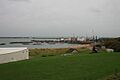
Peterhead Bay. In the background the breakwater built by people from the prison. In the middle distance silos of drilling mud for the offshore oil industry and yachts berthed in the Peterhead marina. In the foreground the roofs of holiday caravans and the "Lido" sands.
-
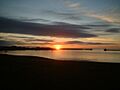
Peterhead Bay. Early morning, calm summer's day. (Left to Right) 'downtown' – harbor – north breakwater – south breakwater. Foreground – above the Lido.
-
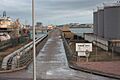
Jetty at Peterhead Bay
-
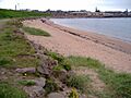
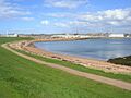
Peterhead Bay, shoreline. A popular area for walking dogs.
-
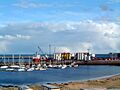
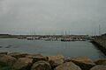
The marina on the south shore of Peterhead Bay.
-
Peterhead Bay marina and jetty facility.
-
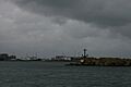
Leaving the marina and entering Peterhead Bay.
-
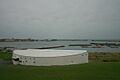
The Heritage Centre overlooking Peterhead Bay.
-
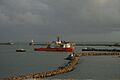
A ship bound for the cement works in Peterhead Bay.


