Peterson, Iowa facts for kids
Quick facts for kids
Peterson,
|
|
|---|---|
 |
|

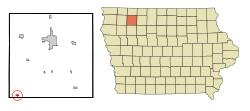
Location of Peterson, Iowa
|
|
| Country | |
| State | |
| County | Clay |
| Area | |
| • Total | 0.54 sq mi (1.40 km2) |
| • Land | 0.52 sq mi (1.34 km2) |
| • Water | 0.02 sq mi (0.06 km2) |
| Elevation | 1,250 ft (381 m) |
| Population
(2020)
|
|
| • Total | 322 |
| • Density | 620.42/sq mi (239.47/km2) |
| Time zone | UTC-6 (Central (CST)) |
| • Summer (DST) | UTC-5 (CDT) |
| ZIP code |
51047
|
| Area code(s) | 712 |
| FIPS code | 19-62625 |
| GNIS feature ID | 0460102 |
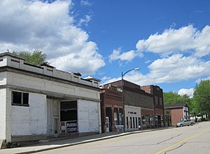
Peterson is a small city in Clay County, Iowa, United States. In the 2020 census, 322 people lived there. This number was a bit smaller than the 372 people who lived there in 2000.
Contents
History of Peterson

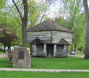
The first people settled in the area of Peterson in 1856. A few years later, in 1862, a special fort was built in Peterson. Settlers built this fort to protect themselves. They were worried about possible attacks during the Dakota War. Luckily, the fort was never attacked.
A part of this old fort, called a blockhouse, is still standing today. You can find it close to its original spot at the corner of Second and Park streets.
Peterson was officially planned out in 1881. This happened when the railroad lines were built to reach the area. The city got its name from Adlie Peterson, who was one of the very first settlers there.
Geography and Location
Peterson is located in Iowa. Its exact position on a map is 42.918490 degrees North and -95.341502 degrees West. It is found close to the Little Sioux River.
The United States Census Bureau says that the city covers a total area of about 0.31 square miles (0.80 square kilometers). All of this area is land.
Population and People
| Historical population | |||
|---|---|---|---|
| Census | Pop. | %± | |
| 1870 | 44 | — | |
| 1890 | 371 | — | |
| 1900 | 521 | 40.4% | |
| 1910 | 480 | −7.9% | |
| 1920 | 580 | 20.8% | |
| 1930 | 598 | 3.1% | |
| 1940 | 603 | 0.8% | |
| 1950 | 589 | −2.3% | |
| 1960 | 565 | −4.1% | |
| 1970 | 469 | −17.0% | |
| 1980 | 470 | 0.2% | |
| 1990 | 390 | −17.0% | |
| 2000 | 372 | −4.6% | |
| 2010 | 334 | −10.2% | |
| 2020 | 322 | −3.6% | |
| U.S. Decennial Census | |||
Peterson's Population in 2020
In 2020, the census showed that 322 people lived in Peterson. There were 159 households and 92 families. Most of the people living in Peterson were White (96.0%). A small number were from two or more races (3.7%). About 2.5% of the people were Hispanic or Latino.
The average age of people in Peterson was 45.3 years old. About 22.0% of the residents were under 20 years old. Also, 23.3% of the people were 65 years old or older. The city had slightly more females (50.9%) than males (49.1%).
Local Media
The local newspaper for Peterson is called the Peterson Patriot. It has been printed since 1880, which means it's been around for a very long time!
Education in Peterson
The community of Peterson is served by the Sioux Central Community School District. This school district helps educate the children in the area.
In the past, Peterson had its own school district. In the early 1960s, it joined with the Linn Grove School District. Together, they formed the Sioux Valley School District. Later, on July 1, 1993, the Sioux Valley district merged again. It joined with the Sioux Rapids-Rembrandt School District. This merger created the Sioux Central district that serves Peterson today.
See also
 In Spanish: Peterson (Iowa) para niños
 | Janet Taylor Pickett |
 | Synthia Saint James |
 | Howardena Pindell |
 | Faith Ringgold |

