Philmont, New York facts for kids
Quick facts for kids
Philmont, New York
|
|
|---|---|

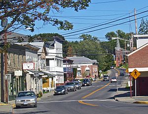
Downtown Philmont, looking east along NY 217
|
|

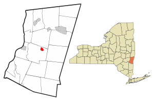
Location of Philmont, New York
|
|

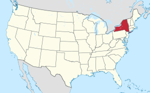
Location of New York in the United States
|
|
| Country | United States |
| State | New York |
| County | Columbia |
| Founded | 1892 |
| Area | |
| • Total | 1.25 sq mi (3.25 km2) |
| • Land | 1.22 sq mi (3.15 km2) |
| • Water | 0.04 sq mi (0.10 km2) |
| Elevation | 500 ft (200 m) |
| Highest elevation
(Unnamed hill in SE quadrant of village)
|
690 ft (210 m) |
| Lowest elevation
(Agawamuck Creek on W boundary)
|
280 ft (90 m) |
| Population
(2020)
|
|
| • Total | 1,377 |
| • Density | 1,132.40/sq mi (437.39/km2) |
| Time zone | UTC-5 (Eastern (EST)) |
| • Summer (DST) | UTC-4 (EDT) |
| ZIP Code |
12565
|
| Area code(s) | 518 |
| FIPS code | 36-57639 |
| GNIS feature ID | 0960311 |
Philmont is a small village located in Columbia County, New York, in the United States. In 2020, about 1,377 people lived here. You can find Philmont in the northeastern part of the town of Claverack, right along Route 217.
Contents
History of Philmont Village
This community was once known as "Factory Hill." This name came from the many wool factories that used to operate here. The village officially became a village in 1891.
Philmont got its name from a person named George P. Philip. He built a large water storage area, called a reservoir, that was about 36-acre (15 ha) big. This reservoir helped provide water for his mill. Later, an even bigger reservoir, about 56-acre (23 ha), was built higher up in the Taconic Mountains. This made sure the mills always had enough water, which helped the "factory hill" grow.
Geography and Location
Philmont is located at 42°14′55″N 73°38′51″W / 42.24861°N 73.64750°W.
The village covers a total area of about 1.23 square miles (3.18 km2). Most of this area, about 1.19 square miles (3.08 km2), is land. The rest, about 0.04 square miles (0.10 km2), is water.
Philmont is situated along the Agawamuck Creek. This creek has a beautiful spot called High Falls near the center of the village, where the water drops a long way. The Agawamuck Creek flows into Claverack Creek, which then travels about 7.5 miles (12.1 km) to reach the Hudson River.
Population and People
| Historical population | |||
|---|---|---|---|
| Census | Pop. | %± | |
| 1880 | 1,343 | — | |
| 1890 | 1,818 | 35.4% | |
| 1900 | 1,964 | 8.0% | |
| 1910 | 1,813 | −7.7% | |
| 1920 | 1,919 | 5.8% | |
| 1930 | 1,868 | −2.7% | |
| 1940 | 1,679 | −10.1% | |
| 1950 | 1,792 | 6.7% | |
| 1960 | 1,750 | −2.3% | |
| 1970 | 1,674 | −4.3% | |
| 1980 | 1,539 | −8.1% | |
| 1990 | 1,623 | 5.5% | |
| 2000 | 1,480 | −8.8% | |
| 2010 | 1,379 | −6.8% | |
| 2020 | 1,377 | −0.1% | |
| U.S. Decennial Census 2020 | |||
In 2000, there were 1,480 people living in Philmont. These people lived in 576 households, with 361 of them being families. The village had about 1,257 people per square mile.
Most of the people in the village were White (94.53%). There were also African American (1.69%), Native American (0.34%), and Asian (0.20%) residents. Some people (1.96%) were from other backgrounds, and 1.28% were from two or more backgrounds. About 3.72% of the population identified as Hispanic or Latino.
About 34.2% of households had children under 18 living with them. Many households (45.0%) were married couples living together. The average household had 2.55 people, and the average family had 3.20 people.
Almost 29% of the population was under 18 years old. The median age in the village was 35 years.
The average income for a household in 2000 was $31,094. For families, the average income was $41,944. About 13.7% of the total population lived below the poverty line.
Places to Visit
One special place in Philmont is the High Falls Conservation Area. This area is about 47-acre (19 ha) and is managed by the Columbia Land Conservancy. High Falls is the tallest waterfall in Columbia County. Its water drops 150 feet (46 m) into a large pool below. This water eventually flows into the Hudson River.
The village is also part of the Taconic Hills Central School District.
Famous People from Philmont
- Oliver North – He was a United States Marine Corps officer and worked for the government during the Reagan era. He also became a contributor for Fox News.
- Claude Rossman – He was a professional baseball player in Major League Baseball from 1904 to 1909.
See also
 In Spanish: Philmont para niños
 | James B. Knighten |
 | Azellia White |
 | Willa Brown |


