
Pigeon Lake (Alberta) facts for kids
Quick facts for kids Pigeon Lake |
|
|---|---|

Looking west over Pigeon Lake at sunset
|
|

Pigeon Lake
Location in Alberta
|
|
| Location | Leduc County and County of Wetaskiwin No. 10, Alberta |
| Coordinates | 53°01′49″N 114°03′48″W / 53.03028°N 114.06333°W |
| Primary outflows | Pigeon Lake Creek |
| Catchment area | 187 km2 (72 sq mi) |
| Basin countries | Canada |
| Max. length | 13.1 km (8.1 mi) |
| Max. width | 14.7 km (9.1 mi) |
| Surface area | 96.7 km2 (37.3 sq mi) |
| Average depth | 6.2 m (20 ft) |
| Max. depth | 9.1 m (30 ft) |
| Surface elevation | 852 m (2,795 ft) |
| Settlements | Argentia Beach, Crystal Springs, Fisher Home, Golden Days, Grandview, Itaska Beach, Ma-Me-O Beach, Mission Beach, Mulhurst Bay, Norris Beach, Pigeon Lake 138A, Poplar Bay, Silver Beach, Sundance Beach, Village at Pigeon Lake |
Pigeon Lake is a beautiful lake in central Alberta, Canada. It sits right on the border between Leduc County and the County of Wetaskiwin No. 10. The lake is not far from big cities like Edmonton, Leduc, and Wetaskiwin.
Many towns and villages are located along the shores of Pigeon Lake. These include the Pigeon Lake Indian Reserve 138A, ten summer villages like Ma-Me-O Beach, and four other communities.
Pigeon Lake covers a large area of about 96.7 square kilometers (37.3 square miles). At its deepest point, it goes down about 9.1 meters (30 feet). Water flows into the lake from an area of 187 square kilometers (72 square miles). The lake is also an early source for the Battle River, connected by a stream called Pigeon Lake Creek.
History of Pigeon Lake
Pigeon Lake was not always called by its current name. It used to be known as "Woodpecker Lake." In 1858, its name was officially changed to Pigeon Lake.
Later, in 1896, the Pigeon Lake Indian Reserve was created on the southeast side of the lake. A popular summer village called Ma-Me-O Beach was built at the south end of the lake. This happened in 1924 on land that was part of the Indian reserve. The name "Ma-Me-O" comes from the Cree language and means "pigeon."
Protecting Pigeon Lake
To help protect the lake and its natural beauty, the Pigeon Lake Provincial Park was created. This park is on the western side of the lake and is a great place to visit. You can reach it easily from Highway 771.
There is also a group called the Pigeon Lake Watershed Association. They work hard to protect the lake. They encourage good practices to keep the lake and the land around it healthy.
Keeping the Lake Healthy
Sometimes, Pigeon Lake has problems with too much green stuff, like algae blooms, growing in the water. These blooms can make the water look cloudy and aren't good for the lake's health. Scientists have studied the lake's water and the mud at the bottom to understand why these blooms happen. They also look at the tiny creatures living in the water that are not fish.
This research helps them figure out where the extra "food" (nutrients) for the algae is coming from. Then, they can plan how to manage the lake better in the future.
The communities around Pigeon Lake are working together to solve this problem. The Pigeon Lake Watershed Association and the Alliance of Pigeon Lake Municipalities are leading these efforts. They have created rules for building and developing land near the shoreline. They also teach people how to take care of their lawns near the lake. This is important because water running off the land is a big source of nutrients that feed the algae.
Images for kids
-
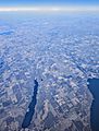
Battle Lake (left) and part of Pigeon Lake (right)

