
Pine Creek (Huntington Creek tributary) facts for kids
Quick facts for kids Pine Creek |
|
|---|---|

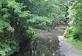
The mouth of Pine Creek
|
|
| Physical characteristics | |
| Main source | Fairmont Township, Luzerne County, Pennsylvania |
| River mouth | Huntington Creek in Fishing Creek Township, Columbia County, Pennsylvania 670 ft (200 m) 41°07′50″N 76°18′09″W / 41.13055°N 76.30253°W |
| Length | 12.4 mi (20.0 km) |
| Basin features | |
| Progression | Huntington Creek → Fishing Creek → Susquehanna River → Chesapeake Bay |
| Basin size | 30.7 sq mi (80 km2) |
| Tributaries |
|
Pine Creek is a cool stream that flows into Huntington Creek in Luzerne County and Columbia County, Pennsylvania. It's about 12.4 miles (20.0 km) long. The creek winds through towns like Fairmont Township, Huntington Township, and New Columbus in Luzerne County, and Fishing Creek Township in Columbia County. The area of land that drains into Pine Creek, called its watershed, is about 30.7 square miles (80 km2). Smaller streams like Bell Branch and Little Pine Creek flow into it. People started settling near the creek in the late 1700s. Long ago, in the early 1900s, people mostly worked in farming and cutting down trees (timber) around the creek. Pine Creek is a special place for fish! It's known as a coldwater fishery and a migratory fishery, meaning it's great for fish that like cold water and for fish that travel. Even northern myotis bats live near the creek.
Contents
Where Does Pine Creek Flow?

Pine Creek starts in western Fairmount Township, Luzerne County. This is close to the border between Luzerne and Columbia Counties. It flows southeast for a few miles, entering a valley. Along the way, it picks up water from smaller streams called Brish Run and Wasp Branch.
The creek then turns south, passing near a place called Red Hill. Further downstream, it enters Huntington Township. Soon after, it gets more water from Bell Creek. Pine Creek keeps flowing south, crossing Pennsylvania Route 239 and entering the small town of New Columbus. After leaving New Columbus, the creek crosses from Luzerne County into Columbia County.
Once in Columbia County, Pine Creek flows through Fishing Creek Township. It makes several twists and turns, called meanders. Finally, it turns south one last time and joins Huntington Creek in the community of Jonestown. Pine Creek meets Huntington Creek about 4.26 miles (6.86 km) before Huntington Creek reaches its own mouth.
Streams That Feed Pine Creek
Many smaller streams flow into Pine Creek, making it bigger. These include Brish Run, Wasp Branch, Bell Creek, Spring Branch, and Little Pine Creek. Little Pine Creek is quite large itself, with a watershed area of 7.15 square miles (18.5 km2). It joins Pine Creek about 2.02 miles (3.25 km) upstream from where Pine Creek meets Huntington Creek.
The Land Around Pine Creek

The area around Pine Creek is described as "rough and hilly." The valley where the creek flows is narrow, and the hills on either side are steep. The creek's path, or channel, is very curvy.
What is the Creek Bed Made Of?
The bottom of Pine Creek's channel is made of sandstone.
How High is Pine Creek?
About 9 miles (14 km) upstream from where it meets Huntington Creek, Pine Creek is about 1,040 feet (320 m) above sea level. Further downstream, about 8 miles (13 km) from its mouth, the elevation is 900 feet (270 m) above sea level. At its mouth, where it joins Huntington Creek, the creek's elevation is 670 feet (200 m) above sea level.
How Much Rain Does the Area Get?
On average, the amount of rain and snow that falls near Pine Creek each year is between 35 to 50 inches (89 to 127 cm).
The Pine Creek Watershed
The watershed of Pine Creek covers an area of 30.7 square miles (80 km2). This important area is located in the northeastern part of Columbia County and the northwestern part of Luzerne County. The highest parts of the watershed are found on North Mountain.
Towns in the Watershed
Some communities located within the Pine Creek watershed include Cambria, New Columbus, and Fairmount Springs. Back in 1921, these towns had populations of 213, 175, and 100 people, respectively.
History of Pine Creek
Early settlers came to live near Pine Creek a long time ago. Johnathan Westover, one of the first people to settle in Huntington Township, chose a spot near Pine Creek. Abram Dodder, whose family was the second to live in Fishing Creek Township, Columbia County, settled by the creek in 1786. His father arrived there two years later, in 1788.
Pine Creek as a Public Highway
In 1814, Pine Creek was officially named a "public highway." This meant it could be used for transporting goods, especially timber. It was used between a sawmill owned by Amos Buckalew in Columbia County and a spot near Johnathan Westover's sawmill in Huntington Township.
A Tornado Near the Creek
On August 19, 1890, a powerful tornado passed by Pine Creek. People reported that the air smelled like sulfur during the tornado. At this point, the tornado was moving very fast, about 60 miles (97 km) per hour!
Industries and Businesses
Around 1820, a woolen mill was built on Little Pine Creek, one of Pine Creek's tributaries. In the 1800s, a person named D. Chatfield Brittain owned a large forest area of 62 acres right on Pine Creek. In the early 1900s, the main jobs and businesses around Pine Creek were agriculture (farming) and timber (cutting down trees for wood).
Wildlife and Nature Around Pine Creek
Pine Creek is home to interesting wildlife.
Northern Myotis Bats
In 1999, scientists observed the northern myotis bat living near Pine Creek. We don't know exactly how many of these bats live there, but it's an important habitat for them.
Fish in the Creek
Pine Creek is a special place for fish. It's called a "coldwater fishery," which means it has the right conditions for fish that prefer cold water. It's also a "migratory fishery," meaning some fish travel through it as part of their life cycle.
Protecting the Creek
The Western Pennsylvania Conservancy, a group that helps protect nature, has suggested creating special "riparian buffers" along several miles of Pine Creek and its smaller streams. These buffers are areas of trees and plants along the banks that help keep the water clean and healthy for all the creatures living there.
Images for kids
-
The mouth of Pine Creek
-
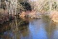
Pine Creek looking upstream in its lower reaches
-
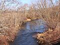
Pine Creek in New Columbus
