Piney, Oklahoma facts for kids
Quick facts for kids
Piney, Oklahoma
|
|
|---|---|

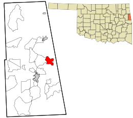
Location within Adair County and the state of Oklahoma
|
|
| Country | United States |
| State | Oklahoma |
| County | Adair |
| Area | |
| • Total | 4.58 sq mi (11.86 km2) |
| • Land | 4.52 sq mi (11.70 km2) |
| • Water | 0.06 sq mi (0.16 km2) |
| Elevation | 1,122 ft (342 m) |
| Population
(2020)
|
|
| • Total | 101 |
| • Density | 22.36/sq mi (8.63/km2) |
| Time zone | UTC-6 (Central (CST)) |
| • Summer (DST) | UTC-5 (CDT) |
| FIPS code | 40-59100 |
| GNIS feature ID | 2584389 |
Piney is a small community in Adair County, Oklahoma, United States. It is known as a census-designated place (CDP). In 2010, about 115 people lived there. Piney holds a special place in history for the Cherokee people. It was the main town for the first group of Cherokee who moved from their original homes in the southeastern U.S. These people were sometimes called the "Old Settlers."
Contents
History of Piney
Piney was founded in 1824 in what was then the Arkansaw Territory. It became the main town for the Cherokee people living in the West. From 1824 to 1828, Piney served as the informal capital city for the Cherokee Nation–West. This was where their council met.
Changes in Territory
The town was located on land from Lovely's Purchase. This land was right on the border of what would become Indian Territory and the state of Arkansas. In 1828, the eastern border of the Indian Territory was finally set. This new border was just one mile east of Piney. The old Arkansaw Territory was then split into two parts.
Moving the Capital
At the same time, a new, permanent capital city for the Cherokee Nation was being built. This new capital, called Tahlonteeskee, was located deeper inside the new Indian Territory. It was in Sequoyah County. Because of these changes, most of the Cherokee residents of Piney soon moved further west. They settled in their new districts within the Indian Territory.
Later Years
A Baptist missionary named Duncan O'Bryant had worked in Piney for some time. He stayed behind after most of the Cherokee left. He passed away in 1834, and his grave is still located there.
Piney had its own post office from November 24, 1913, until August 20, 1921. The town was at its biggest around 1916. It had a general store, which also housed the post office. There was also a gristmill (for grinding grain), a blacksmith's shop, and a school. The old school building is now used as a community center. The town continued to be officially recognized until 1940. Today, the original settlement of Piney is considered a ghost town. However, some people still live in the area as of 2011.
Geography of Piney
Piney is located in the eastern part of Adair County, Oklahoma. It is about 1 mile (1.6 km) west of the Arkansas border. The Piney CDP covers a total area of about 4.6 square miles (11.9 square kilometers). Most of this area, about 4.5 square miles (11.7 square kilometers), is land. The remaining small part, about 0.08 square miles (0.2 square kilometers), is water. This means about 1.32% of the area is water.
Population Information
| Historical population | |||
|---|---|---|---|
| Census | Pop. | %± | |
| 2020 | 101 | — | |
| U.S. Decennial Census | |||
In 2020, the population of Piney was 101 people. This information comes from the U.S. Decennial Census, which counts the population every ten years.
See also
 In Spanish: Piney (Oklahoma) para niños
 | Tommie Smith |
 | Simone Manuel |
 | Shani Davis |
 | Simone Biles |
 | Alice Coachman |

