Pitchoff Mountain facts for kids
Quick facts for kids Pitchoff Mountain |
|
|---|---|

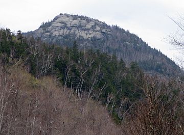
Pitchoff Mountain from NY 73
|
|
| Highest point | |
| Elevation | 3,600 ft (1,100 m) |
| Prominence | 1,135 ft (346 m) |
| Geography | |
| Location | Keene / North Elba, New York, U.S. |
| Parent range | Adirondacks |
| Topo map | USGS Keene Valley |
Pitchoff Mountain is a cool mountain in New York State. It stands opposite Cascade Mountain and is part of the beautiful Adirondacks. This mountain is located near Keene Valley in Essex County, New York. It's a popular spot for hikers who want to explore nature and see amazing views. Pitchoff Mountain reaches about 3,600 feet (1,097 meters) high.
Contents
Exploring Pitchoff Mountain
Pitchoff Mountain is a special place for outdoor adventures. It offers a great way to experience the wild beauty of the Adirondacks. Many people visit to enjoy the fresh air and stunning scenery. The mountain has two main peaks, each with its own features.
Where is Pitchoff Mountain?
Pitchoff Mountain is found in Essex County, New York. It's right along NY 73, a main road that runs through the Adirondacks. The mountain is located between the towns of Keene and North Elba. Its location makes it easy to access for hikers and nature lovers.
Amazing Views from the Top
Pitchoff Mountain has two summits, or peaks. The very highest point of the mountain doesn't have open views. However, the northern summit, which is about 3,323 feet (1,013 meters) high, offers incredible sights! From this northern peak, you can see all around you, a full 360-degree view.
You can look down at the nearby Cascade Lakes, which are sparkling bodies of water. You'll also see the famous Adirondack High Peaks, which are some of the tallest mountains in New York. On a clear day, you might even be able to spot the Green Mountains far away in Vermont! It's a perfect spot for taking photos and enjoying nature's beauty.
Hiking the Pitchoff Trail
There is a popular hiking trail that takes you up and across Pitchoff Mountain. This trail is about 5.2 miles (8.4 kilometers) long. It's a great way to explore the mountain's different areas.
The trail starts on Route 73, west of the Cascade Lakes. You'll hike uphill for about 2.0 miles (3.2 kilometers) to reach the highest summit. After that, the trail continues along the mountain's ridge for almost two miles. This part of the hike is very scenic. Finally, the trail goes downhill for about 1.4 miles (2.3 kilometers) to end back on Route 73. The end point is about 2.7 miles (4.3 kilometers) east of where you started. It's a fun adventure for those who enjoy a good hike!
 | Precious Adams |
 | Lauren Anderson |
 | Janet Collins |

