Plains, Georgia facts for kids
Quick facts for kids
Plains, Georgia
|
||
|---|---|---|

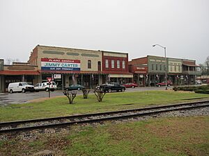
Plains downtown storefronts (2011)
|
||
|
||
| Motto(s):
"Home of the 39th President"
|
||

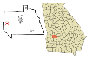
Location within Sumter County and Georgia
|
||
| Country | United States | |
| State | Georgia | |
| County | Sumter | |
| Founded | 1885 | |
| Area | ||
| • Total | 0.81 sq mi (2.11 km2) | |
| • Land | 0.81 sq mi (2.11 km2) | |
| • Water | 0.00 sq mi (0.00 km2) | |
| Elevation | 499 ft (152 m) | |
| Population
(2020)
|
||
| • Total | 573 | |
| • Density | 707/sq mi (271.6/km2) | |
| Time zone | UTC−5 (EST) | |
| • Summer (DST) | UTC−4 (EDT) | |
| ZIP Code |
31780
|
|
| Area code | 229 | |
| FIPS code | 13-61628 | |
| GNIS ID | 356474 | |
Plains is a small city in Sumter County, Georgia, United States. In 2020, about 573 people lived there. Plains is most famous for being the hometown of Jimmy Carter and his wife Rosalynn. Jimmy Carter was the 39th president of the United States from 1977 to 1981. Rosalynn Carter was the First Lady.
Contents
History of Plains
Long ago, the Muscogee people lived in this area. By the 1840s, three small villages were near where Plains is today. These were Lebanon, Magnolia Springs, and Plains of Dura.
A big change happened in 1885 when a major railroad line reached the area. The three small villages joined together to form one larger settlement. More businesses quickly grew around the new railway. Local leaders asked the state government to shorten the name "Plains of Dura" to just "Plains." The city officially became a town in 1896.
Plains grew because of cotton farming in the early 1900s. A large school and a special hospital called the Wise Sanitarium were built in the 1920s. But the town faced hard times during the Great Depression. This was a period when many people lost their jobs and money. Even though farmers started growing peanuts, the community lost much of its wealth.
Plains stayed a small, quiet town for many years. This changed when Jimmy Carter, who grew up in Plains, became Georgia's governor in 1971. He then became the U.S. president in 1977. During his election in 1976 and for many years after, Plains became a very popular place to visit. Nearly 10,000 tourists came to the town every day. This was about 18 times more people than lived in Plains!
Where is Plains?
Plains is located in the western part of Georgia. It covers an area of about 0.8 square miles (2.1 square kilometers). The city's border is shaped like a circle. Plains is about 120 miles (193 kilometers) south of Atlanta, Georgia's capital city.
Plains' Climate
The weather in Plains has hot, humid summers. Winters are usually mild to cool. Plains has a humid subtropical climate. This means it gets a lot of rain and has warm temperatures for most of the year.
| Climate data for Plains, Georgia | |||||||||||||
|---|---|---|---|---|---|---|---|---|---|---|---|---|---|
| Month | Jan | Feb | Mar | Apr | May | Jun | Jul | Aug | Sep | Oct | Nov | Dec | Year |
| Mean daily maximum °F (°C) | 57 (14) |
61 (16) |
68 (20) |
77 (25) |
84 (29) |
89 (32) |
91 (33) |
90 (32) |
86 (30) |
78 (26) |
69 (21) |
60 (16) |
76 (24) |
| Mean daily minimum °F (°C) | 35 (2) |
37 (3) |
44 (7) |
51 (11) |
60 (16) |
67 (19) |
69 (21) |
69 (21) |
64 (18) |
53 (12) |
44 (7) |
37 (3) |
52 (11) |
| Average precipitation inches (mm) | 4.9 (120) |
4.6 (120) |
5.2 (130) |
3.5 (89) |
3.3 (84) |
4.7 (120) |
5.2 (130) |
4.5 (110) |
3.5 (89) |
2.4 (61) |
3.3 (84) |
4.2 (110) |
49.4 (1,250) |
| Source: Weatherbase | |||||||||||||
Population of Plains
Plains is part of the Americus area, which is a small group of towns. The population of Plains has changed over the years.
| Historical population | |||
|---|---|---|---|
| Census | Pop. | %± | |
| 1870 | 374 | — | |
| 1880 | 459 | 22.7% | |
| 1890 | 510 | 11.1% | |
| 1900 | 290 | −43.1% | |
| 1910 | 407 | 40.3% | |
| 1920 | 479 | 17.7% | |
| 1930 | 406 | −15.2% | |
| 1940 | 364 | −10.3% | |
| 1950 | 359 | −1.4% | |
| 1960 | 273 | −24.0% | |
| 1970 | 236 | −13.6% | |
| 1980 | 231 | −2.1% | |
| 1990 | 286 | 23.8% | |
| 2000 | 637 | 122.7% | |
| 2010 | 776 | 21.8% | |
| 2020 | 573 | −26.2% | |
| U.S. Decennial Census 1850-1870 1870-1880 1890-1910 1920-1930 1940 1950 1960 1970 1980 1990 2000 2010 2020 |
|||
Schools in Plains
The schools in Plains are part of the Sumter County School District.
Things to See and Do
Many interesting places in Plains are connected to Jimmy Carter National Historical Park. This park protects important sites from President Carter's life. You can visit:
- Carter's high school, which is now a visitor center and museum.
- The place where he was born.
- His old campaign headquarters.
- The former site of his family's business.
- His brother Billy's old service station.
These places are all close to each other in the center of town. You can also see the famous Smiling Peanut Statue on the edge of town. It was a gift to Carter from his supporters. His childhood home is in a nearby town called Archery.
Other interesting places near Plains include:
- Andersonville National Historic Site, which was a prison camp during the American Civil War. It also has the National Prisoner of War Museum.
- Georgia Southwestern State University is in the nearby town of Americus.
- Westville is a re-created town in Lumpkin. It shows what life was like in Georgia in the mid-1800s.
Famous People from Plains
Plains is the birthplace of President Jimmy Carter. He was born at the Wise Sanitarium, which is now called the Lillian G. Carter Nursing Center after his mother. His wife Rosalynn and their daughter Amy were also born in Plains. His younger brother Billy and his sisters Gloria and Ruth were also from Plains.
After leaving office in 1981, Jimmy and Rosalynn Carter returned to live in their home in Plains. They had lived there since 1961. Rosalynn Carter passed away on November 19, 2023, and Jimmy Carter passed away on December 29, 2024.
Images for kids
-
The Plains welcome sign, featuring the Seal of the president of the United States
-
The Plains water tower
-
Carter's High School, now a visitor center and museum
-
Jimmy Carter cycling in Plains (2008)
See also
 In Spanish: Plains (Georgia) para niños


