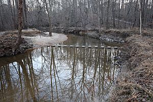
Pohick Creek facts for kids
Quick facts for kids Pohick Creek |
|
|---|---|
|
Location of Pohick Creek mouth
|
|
| Other name(s) | Tributary to Potomac River |
| Country | United States |
| State | Virginia |
| County | Fairfax |
| Physical characteristics | |
| Main source | confluence of Rabbit Branch and Sideburn Branch Fairfax, Virginia 262 ft (80 m) 38°47′52″N 077°17′04″W / 38.79778°N 77.28444°W |
| River mouth | Potomac River (Pohick Bay) about 0.5 miles north of Springfield Farms, Virginia 0 ft (0 m) 38°41′07″N 077°11′12″W / 38.68528°N 77.18667°W |
| Length | 14.32 mi (23.05 km) |
| Basin features | |
| Progression | southeast |
| River system | Potomac River |
| Basin size | 32.21 square miles (83.4 km2) |
| Tributaries |
|
| Waterbodies | Lake Royal |
| Bridges | Commonwealth Boulevard, Guinea Road, Burke Lake Road, Old Keene Mill Road, VA 286, Pohick Road, I-95, Lorton Road, US 1, Old Colchester Road |

Pohick Creek is a stream about 14.0-mile-long (22.5 km) in Fairfax County, Virginia. It flows into the Potomac River. The creek gets its name from the Pohick Native American tribe. This tribe once lived in the area.
Pohick Creek starts near Burke. It flows southeast, passing the edge of Fort Belvoir. The creek then empties into Pohick Bay. This bay is connected to Gunston Cove, which is part of the tidal Potomac River.
The creek is a fun spot for water sports. People enjoy whitewater kayaking, rafting, and paddling here. There are exciting Class II and III rapids. These rapids stretch for about 5.5-mile (8.9 km). They are found between Hooes Road and U.S. Route 1 in Lorton.
Contents
How Dams Help Pohick Creek
Many smaller streams that feed into Pohick Creek have dams. These dams were built to stop soil from washing away and to prevent floods. They were part of a plan called the Watershed Protection and Flood Prevention Act. Eight dams were originally planned, but only six were built between 1970 and 1985.
Lakes Formed by Dams
- Lake Braddock (Pohick #7) was the first dam. It was built in 1970. This dam holds back Pohick Creek in Burke.
- Huntsman Lake (Pohick #8) was built in 1973. It holds back the Middle Run in Springfield.
- Lake Royal (Pohick #4) was finished in 1977. It holds back the Rabbit Branch in Burke. The Rabbit Branch joins the Sideburn Branch to form Pohick Creek.
- Lake Barton (Pohick #2) was completed in 1978. It holds back a smaller stream that flows into the Sideburn Branch in Burke.
- Woodglen Lake (Pohick #3) was finished in 1981. It holds back the Sideburn Branch in Fairfax.
- Lake Mercer (Pohick #1) was the last dam built in 1985. It holds back the South Run in Springfield.
Other Names for Pohick Creek
The United States Geological Survey lists a few other names for Pohick Creek. These names have been used in the past.
- North West Branch
- Poehick Creeke
- Poheick Creek
- West Branch
Where Pohick Creek Flows
Pohick Creek begins where two smaller streams meet. These are Rabbit Branch and Sideburn Branch in Burke, Virginia. From there, Pohick Creek flows southeast. It forms the boundary between Burke and West Springfield.
After crossing the Fairfax County Parkway, the creek enters Newington. Here, it flows through a deep valley. The Gerry Connolly Cross County Trail follows the creek in this area. The trail crosses the creek eight times.
The creek then goes into Lorton. It flows under Interstate 95, the CSX train tracks, and U.S. Route 1. Finally, Pohick Creek meets the Potomac River in Pohick Bay. This meeting point is about 0.5 miles north of Springfield Farms.
Pohick Creek's Watershed
A watershed is an area of land where all the water drains into a single river or stream. The Pohick Creek watershed covers about 32.21 square miles (83.4 km2). This area gets about 43.5 inches of rain each year. About 31% of the land in the watershed is covered by forests.
Images for kids
 | Sharif Bey |
 | Hale Woodruff |
 | Richmond Barthé |
 | Purvis Young |


