Springfield, Virginia facts for kids
Quick facts for kids
Springfield, Virginia
|
||
|---|---|---|
|
Census-designated place (CDP)
|
||

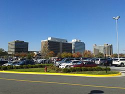
Central Springfield Business District, seen from Springfield Town Center in October 2014
|
||
|
||

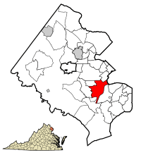
Location of Springfield in Fairfax County, Virginia
|
||
| Country | ||
| State | ||
| County | ||
| Area | ||
| • Total | 7.9 sq mi (20.4 km2) | |
| • Land | 7.9 sq mi (20.3 km2) | |
| • Water | 0.0 sq mi (0.1 km2) | |
| Elevation | 246 ft (75 m) | |
| Population
(2020)
|
||
| • Total | 31,339 | |
| • Density | 3,966.9/sq mi (1,536.2/km2) | |
| Time zone | UTC−5 (Eastern (EST)) | |
| • Summer (DST) | UTC−4 (EDT) | |
| Area code(s) | 703, 571 | |
| FIPS code | 51-74592 | |
| GNIS feature ID | 1493642 | |
Springfield is a community in Fairfax County, Virginia, USA. About 31,339 people lived here in 2020, according to the U.S. Census Bureau. In 2010, the population was 30,484.
Many homes and businesses in nearby areas like North Springfield, West Springfield, and Newington use a Springfield mailing address. If you count all these areas, the population is thought to be over 100,000 people. Springfield is part of Northern Virginia, which is the most populated area around Washington, D.C..
Contents
Geography of Springfield
Springfield is located at 38°46′45″N 77°11′4″W / 38.77917°N 77.18444°W.
The United States Census Bureau says that Springfield covers about 7.9 square miles (20.4 km2). Most of this area, 7.9 square miles (20.3 km2), is land. Only a small part, 0.04 square miles (0.1 km2), is water.
Major Roads and Location
The area is mostly known for a big highway intersection called the Springfield Interchange. This is where I-95, I-395, and the Capital Beltway (I-495) all meet.
The center of Springfield is near the crossing of Route 644 (Old Keene Mill Road / Franconia Road) and Route 617 (Backlick Road). There are many shops and businesses around this intersection. However, most of Springfield is made up of homes.
Springfield ZIP Codes
The U.S. Postal Service uses four different ZIP codes for the Springfield area:
- 22150: This is often called Central Springfield and covers the main community.
- 22151: This is for North Springfield.
- 22152: This is for West Springfield.
- 22153: This covers parts of Burke, West Springfield, and Newington Forest.
Here is a table showing the size of these ZIP code areas:
| Zip code | Total area | Water area | Land area |
|---|---|---|---|
| 22150 | 7.88 sq mi. | 0.01 sq mi. | 7.87 sq mi. |
| 22151 | 5.28 sq mi. | 0.17 sq mi. | 5.11 sq mi. |
| 22152 | 6.16 sq mi. | 0.00 sq mi. | 6.16 sq mi. |
| 22153 | 8.36 sq mi. | 0.06 sq mi. | 8.30 sq mi. |
| Total | 28.50 sq mi. | 0.24 sq mi. | 28.27 sq mi. |
History of Springfield
Early Beginnings in the 1800s
Between 1796 and 1800, a saw and grist mill was built in the Springfield area. It was owned by James Keene, and that's how Old Keene Mill Road got its name. The mill helped local farms for about 60 years. Today, only two mill races (channels for water to power the mill) remain.
Springfield started in 1847 around the Daingerfield Station of the Orange and Alexandria Railroad. This station is now the Backlick Road Virginia Railway Express station. The area was named after "Springfield Farm," which belonged to Henry Daingerfield. He was a businessman from Alexandria and was on the railroad's board.
A post office was set up after 1851. It was there during the American Civil War. There was a small fight on October 3, 1861, and a Confederate raid on August 3, 1863. The station was the first Springfield Post Office from 1866 to 1868.
In 1877, Richard Moore asked for a new post office, which he called Moor. It was located about a mile south of the station. In 1881, the post office name changed to Garfield to honor the late President James A. Garfield, who had been assassinated that year.
Springfield in the 1900s
In 1907, the Garfield post office closed. A new postal station called Corbett opened back at the railroad station. The name "Springfield" was officially brought back on June 27, 1910. Even so, the name Garfield still appeared on some maps until the 1930s. The post office moved to a new spot in 1933.
Until at least 1946, Springfield was a quiet, rural area. Then, a real estate developer named Edward Carr decided to build new homes there. This was because of the new Henry Shirley Highway (now I-95/I-395). Carr thought this was the last easy-to-reach area within 12 miles (19 km) of Washington, D.C.. The new community grew very quickly.
In 1950, about 1,000 people lived in Springfield. Springfield United Methodist Church was started in 1954, and John Lewis High School (formerly Robert E. Lee) was built in 1957. By 1960, the population was over 10,000. It grew to more than 25,000 by 1970, with new neighborhoods like North and West Springfield.
Between 1973 and 1975, Springfield became a big shopping area. The Springfield Mall (now Springfield Town Center) opened. It was the second large shopping center in Northern Virginia. Other shopping centers like Springfield and Brookfield also opened.
In the 1980s and 1990s, more shops and apartments were built. This growth continued until the Franconia-Springfield Parkway opened in 1996. The Franconia-Springfield Metro and Virginia Rail Express Station opened in 1997, making it easier to travel.
Springfield in the 2000s
The Springfield Mall was updated and reopened in 2014. It is now known as Springfield Town Center.
Important Buildings in Springfield
The main part of Springfield is at Route 644 (Old Keene Mill Road / Franconia Road) and Route 617. The old name "Garfield" is still used for the nearby Garfield Elementary School.
The Sydenstricker School, which was finished in 1928, was added to the National Register of Historic Places in 2012. This means it is a historically important building.
People and Community in Springfield
In 2010, there were 30,484 people living in Springfield. There were 12,431 houses and 7,472 families. The population density was about 3,869.5 people per square mile (1,494.0 per km2).
The people in Springfield come from many different backgrounds. In 2010, the racial makeup was:
- 48.7% White
- 9.0% African American
- 0.7% Native American
- 24.3% Asian
- 0.1% Pacific Islander
- 12.5% from other races
- 4.7% from two or more races
About 25.5% of the population was Hispanic or Latino of any race.
In 2000, about 32.9% of households had children under 18 living with them. Most households (58.0%) were married couples. The average household had 2.88 people, and the average family had 3.37 people. In 2010, the average household size was 2.82.
The median age in Springfield was 36 years old. About 22.5% of the population was under 18.
The median income for a household in Springfield in 2010 was $84,309. For a family, it was $95,158.
The total population for all the Springfield ZIP codes combined was 100,208 people.
Shopping in Springfield

The Springfield Mall used to be a very large indoor shopping mall. It was located near the Springfield Interchange. It had several big stores and a food court.
In 2005, a company bought the mall. They closed it for renovations and reopened it in 2014 as "Springfield Town Center."
Transportation in Springfield
Roads and Highways
The center of Springfield is dominated by the Springfield Interchange. People often call it the "Mixing Bowl" or the "Melting Pot." This is a very complex intersection of three Interstates: I-95, I-395, and I-495. It also includes special lanes for HOV traffic.
This big road project was built between 1999 and 2007. It cost $676 million and was finished on time.
Public Transportation
Trains
Springfield has train services for commuters:
- Virginia Railway Express commuter rail at the Backlick Road station and the Franconia-Springfield Station (on the Fredericksburg Line).
- Washington Metro's Blue Line at the Franconia–Springfield station.
Buses
Several bus services operate in Springfield:
- Fairfax Connector bus
- Greyhound bus
- BestBus
- Washington Metropolitan Area Transit Authority bus
- OmniRide bus
Airports Near Springfield
The closest airport to Springfield is the Ronald Reagan Washington National Airport, located in Crystal City, Virginia. Other nearby airports include:
- Washington Dulles International Airport, in Chantilly and Sterling, Virginia.
- Baltimore-Washington International Thurgood Marshall Airport in Linthicum, Maryland.
Economy of Springfield
The main office for the company Ensco is located in the Ravensworth community, but it uses a Springfield mailing address.
Education in Springfield
Public schools in Springfield are managed by Fairfax County Public Schools.
Some neighborhoods in Springfield send students to schools outside the main Springfield area. These include schools in the Lake Braddock, South County, and Hayfield districts. Also, some schools in Springfield get students from areas outside Springfield itself.
Elementary Schools
Elementary schools that serve the Springfield area include:
- Cardinal Forest Elementary School (in West Springfield)
- Crestwood Elementary School
- Garfield Elementary School
- Forestdale Elementary School
- Hunt Valley Elementary School
- Keene Mill Elementary School (West Springfield)
- Kings Glen Elementary School
- Kings Park Elementary School (in Kings Park)
- Lynbrook Elementary School
- Newington Forest Elementary School
- North Springfield Elementary School (in North Springfield)
- Orange Hunt Elementary School
- Ravensworth Elementary School (in Ravensworth)
- Rolling Valley Elementary School (West Springfield)
- Sangster Elementary School
- Springfield Estates Elementary School
- Saratoga Elementary School
- West Springfield Elementary School (West Springfield)
Middle Schools
Middle schools serving Springfield include:
- Francis Scott Key Middle School
- Washington Irving Middle School (West Springfield)
High Schools
High schools serving Springfield include:
- John Lewis High School (formerly Robert E. Lee)
- West Springfield High School in West Springfield. The dance team from West Springfield High School appeared on the TV show America's Got Talent.
Private Schools and Colleges
Private schools near Springfield include:
- St. Bernadette School (part of the Roman Catholic Diocese of Arlington) in West Springfield
- Springfield Academy
- Word of Life Christian Academy
- Iqra Elementary
- Al-Qalam Academy
The medical campus of Northern Virginia Community College is also in Springfield. It offers different associates degrees and certificates.
Library Services
The Fairfax County Public Library system runs two libraries in the area: the Richard Byrd Library and the Pohick Regional Library.
See also
 In Spanish: Springfield (Virginia) para niños
 | John T. Biggers |
 | Thomas Blackshear |
 | Mark Bradford |
 | Beverly Buchanan |


