
Chantilly, Virginia facts for kids
Quick facts for kids
Chantilly
|
|
|---|---|
_at_Sullyfield_Circle,_Centerview_Drive,_Centreville_and_Walney_Roads_in_Chantilly,_Virginia,_viewed_from_a_plane_heading_for_Washington_Dulles_International_Airport.jpg)
Central Chantilly
|
|

Location of Chantilly in Fairfax County, Virginia
|
|

Chantilly
Location in Northern Virginia

Chantilly
Location in Virginia

Chantilly
Location in the United States
|
|
| Country | United States |
| State | Virginia |
| County | Fairfax |
| Area | |
| • Total | 12.12 sq mi (31.40 km2) |
| • Land | 12.00 sq mi (31.09 km2) |
| • Water | 0.12 sq mi (0.32 km2) |
| Elevation | 322 ft (98 m) |
| Population
(2020)
|
|
| • Total | 24,301 |
| • Density | 2,024/sq mi (781.6/km2) |
| Time zone | UTC−5 (Eastern) |
| • Summer (DST) | UTC−4 (Eastern) |
| ZIP Codes |
20151–20153
|
| Area code(s) | 703, 571 |
| FIPS code | 51-14744 |
| GNIS feature ID | 1495375 |
Chantilly is a community located in Fairfax County, Virginia, in the United States. It's called a census-designated place (CDP), which means it's a special area defined for gathering population information. In 2020, about 24,301 people lived there.
Chantilly got its name from a large house and farm built in the early 1800s. That farm was named after an even older plantation from the 1700s in a different part of Virginia. The name "Chantilly" originally comes from the beautiful Château de Chantilly in France, which is a famous castle north of Paris.
This area is part of Northern Virginia, which is close to Washington, D.C.. Chantilly is about 25 miles (40 km) west of Washington, D.C. You can get there using major roads like Interstate 66 and U.S. Route 50. Chantilly is surrounded by other towns like Centreville to the south, and Herndon and Reston to the north. Two important highways, U.S. Route 50 and Virginia State Route 28, cross paths in Chantilly. These roads help people get to places like Dulles International Airport and other big work areas in Northern Virginia.
Contents
History of Chantilly
Chantilly was once home to many large farms, called plantations, in the 1700s. One famous plantation was Sully Plantation, built by Richard Bland Lee I. Today, you can still visit it as the Sully Historic Site. Another important plantation was called "Chantilly Plantation." The community of Chantilly is named after this old plantation.
The Chantilly Plantation was built by Cornelia Lee Turberville Stuart and her husband, Charles Calvert Stuart. They named it after a plantation owned by Cornelia's grandfather, Richard Henry Lee. He was a very important person who signed the Declaration of Independence.
During the American Civil War, soldiers from the Union Army burned down the main house of the Chantilly Plantation. Only one stone building from that time still stands today. It's across Route 50 from the Greenbriar Shopping Center. Historians believe this stone house might have been a home for a plantation overseer before the war, or a guesthouse later on.
The area of Chantilly started to grow more in the 1800s, especially after the Little River Turnpike road was built. After 1980, Chantilly really began to change. Developers built many new homes and businesses, turning old farmlands into the busy suburban area you see today.
-
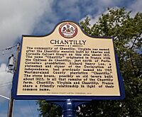
A historic marker showing where the Old Chantilly Farm House once stood.
-
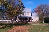
The main house at Sully Plantation, now a historic site.
-
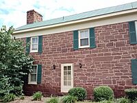
The Stone House, the only building left from the original Chantilly Plantation.


The Civil War Battle

A very important event during the American Civil War happened near Chantilly. On September 1, 1862, the Battle of Chantilly (also known as the Battle of Ox Hill) took place. After winning a battle nearby, Confederate General Robert E. Lee sent his troops to try and attack the Union Army from behind.
During the battle, which happened in a big storm, two Union generals, Isaac Stevens and Philip Kearny, were killed. The fighting stopped when it got dark. Even though much of the battlefield is now covered by buildings, a small area called Ox Hill Battlefield Park helps preserve a part of this historic site.
Geography of Chantilly
Chantilly is located in the western part of Fairfax County. It's next to South Riding in Loudoun County to the west and Washington Dulles International Airport to the north. To the east is Greenbriar, and to the south is Centreville.
The main part of Chantilly is where U.S. Route 50 (Lee Jackson Memorial Highway) and Virginia Route 28 (Sully Road) meet. The community covers about 12.1 square miles (31.5 square kilometers) of land.
How Chantilly is Governed
Chantilly is part of the Sully District in Fairfax County. It is managed by the Fairfax County Board of Supervisors. The person who represents the Sully District on this board is Kathy Smith.
Population Information
| Historical population | |||
|---|---|---|---|
| Census | Pop. | %± | |
| 1980 | 12,259 | — | |
| 1990 | 29,337 | 139.3% | |
| 2000 | 41,041 | 39.9% | |
| 2010 | 23,039 | −43.9% | |
| 2020 | 24,301 | 5.5% | |
| source: | |||
In 2020, Chantilly had a population of 24,301 people. The community is quite diverse, with people from many different backgrounds living there. Many households are families, and a good number of people speak languages other than English at home.
Economy and Jobs
Several important organizations have offices or headquarters near Chantilly. For example, the American Registry for Internet Numbers, which helps manage internet addresses, is located here.
Interesting Places and Organizations


Chantilly has some cool places and important organizations:
- Ellanor C. Lawrence Park: This park is along Route 28. It has an old farmhouse, trails for walking, and sports fields. It's a great place to explore nature.
- Flat Lick Stream Valley Park: Another park with natural areas.
- The Steven F. Udvar-Hazy Center: This is a huge annex of the National Air and Space Museum. It's where you can see amazing airplanes and spacecraft, including the Space Shuttle Discovery!
- The headquarters of the National Reconnaissance Office (NRO): This is one of the most important U.S. intelligence agencies. They design and operate spy satellites for the government. These satellites help gather important information for national security.
Schools and Libraries
Students living in Chantilly go to schools run by Fairfax County Public Schools.
There are several elementary schools in the area, including Brookfield, Bull Run, Greenbriar East, Greenbriar West, Lees Corner, Navy, and Poplar Tree Elementary Schools. For middle school, students might attend Rocky Run Middle School or Franklin Middle School. The main high school in the area is Chantilly High School. Westfield High School is also nearby.
There are also private Catholic schools like St. Timothy School and St. Veronica School.
For books and learning, the Fairfax County Public Library operates the Chantilly Regional Library in the community.
Local News
Chantilly has its own local newspaper called The CentreView.
Famous People from Chantilly
Some notable people who have lived in or are connected to Chantilly include:
- Chris Beatty, an American football coach
- Chuck Caputo, a politician in the Virginia House of Delegates
- Kaye Dacus, an author
- Phil Hubbard, a former professional basketball player
- Bhawoh Jue, a former professional American football player
- Joe Koshansky, a professional baseball player
- Alessandra Marc, a dramatic opera singer
- Jimmy Martin, a former professional American football player
- Cameron Nizialek, a professional American football player
- Eddie Royal, a former professional American football player
- Evan Royster, a former professional American football player
See also
 In Spanish: Chantilly (Virginia) para niños
