Centreville, Virginia facts for kids
Quick facts for kids
Centreville
|
|
|---|---|
|
Census-designated Place (CDP)
|
|
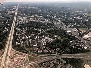
An aerial view of SR 28 (bottom), I-66 (left) and US 29 (right) in Centreville in July 2019
|
|
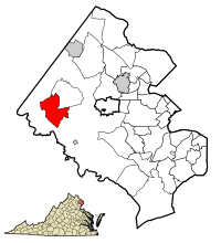
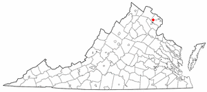
Location of Centreville in Fairfax County, Virginia
|
|
| Country | United States |
| State | Virginia |
| County | Fairfax |
| Area | |
| • Census-designated Place (CDP) | 12.05 sq mi (31.2 km2) |
| • Land | 11.94 sq mi (30.9 km2) |
| • Water | .11 sq mi (0.3 km2) |
| Elevation | 384 ft (117 m) |
| Population
(2020)
|
|
| • Census-designated Place (CDP) | 73,518 |
| • Density | 6,157/sq mi (2,377/km2) |
| • Urban | 4,586,770 |
| • Metro | 6,385,162 |
| Time zone | UTC-5 (EST) |
| • Summer (DST) | UTC-4 (EDT) |
| ZIP Codes |
20120-20122
|
| Area code(s) | 703, 571 |
| FIPS code | 51-14440 |
| GNIS feature ID | 1491083 |
Centreville is a community in Fairfax County, Virginia, United States. It's known as a census-designated place (CDP). This means it's an area that looks like a town but isn't officially a city or town with its own local government.
Centreville is a suburb of Washington, D.C., which is the nation's capital. In 2020, about 73,518 people lived there. This made it the community with the most people in Fairfax County. Centreville is about 20 miles (32 km) west of Washington, D.C.
Contents
History of Centreville
How Centreville Began
In the 1760s, the area was called Newgate. This name came from a popular place called the Newgate tavern. William Carr Lane ran this tavern. He also owned a store nearby with James Lane, Jr. The Lanes sometimes sold the work of people who had to work to pay off their debts. This might be why the tavern shared its name with a famous prison in London. A small stream nearby was even named the River Thames, like the river in London. Another idea is that it was a "new gate" to the lands further west.
Centreville in the 1700s
The town of Centerville, later spelled Centreville, was officially started in 1792. It was built on a main road, a "turnpike," at the village of Newgate. Local landowners asked the Virginia General Assembly to create the town. They thought a town in this central spot would be helpful for travelers and trade. It was located between several important places like Alexandria and Leesburg. The town got its name because it was in a "central" location.
When it first started, Centreville was part of Loudoun County, Virginia. But in 1798, the county lines changed, and it became part of Fairfax County, Virginia. The town grew with homes, taverns, stores, and even a school.
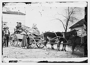
Centreville During the Civil War
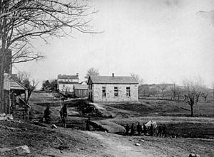
During the American Civil War, Centreville was a very important place. Many battles happened nearby, including the First Battle of Manassas and the Second Battle of Manassas.
In the winter of 1861 and early 1862, the Confederate side built many defenses around the town. Centreville was used as a place to store supplies for both sides during the war. It's also famous for having the first railroad ever built just for military use, called the Centreville Military Railroad.
Centreville was important because it was near several main roads. Also, it was on a high ridge, which gave a great view of the area around it. The town was often linked to Confederate Colonel John S. Mosby. His special group of soldiers, called partisan rangers, used the hills and farms around Centreville as their base. This led to the area being called "Mosby's Confederacy."
Centreville in Recent Times
Like many areas in Northern Virginia, Centreville grew a lot in the 1990s and 2000s. Today, it is a large community with many shopping centers and places to live.
Geography of Centreville
Centreville is located at 38°50′33″N 77°26′33″W.
According to information from 2010, the Centreville area covers about 12.04 square miles (31.2 square kilometers). Almost all of this area is land.
Climate in Centreville
Centreville has a climate with four distinct seasons. It's known as a humid subtropical climate. This means it has warm, wet summers and chilly, damp winters. There is usually some frost at night in winter and a bit of snow. Summers can be quite hot and humid.
| Month | Jan | Feb | Mar | Apr | May | Jun | Jul | Aug | Sep | Oct | Nov | Dec | Year |
|---|---|---|---|---|---|---|---|---|---|---|---|---|---|
| Record high °F (°C) | 79 (26) |
84 (29) |
93 (34) |
95 (35) |
99 (37) |
104 (40) |
106 (41) |
106 (41) |
104 (40) |
98 (37) |
86 (30) |
79 (26) |
106 (41) |
| Mean maximum °F (°C) | 66.7 (19.3) |
68.1 (20.1) |
77.3 (25.2) |
86.4 (30.2) |
91.0 (32.8) |
95.7 (35.4) |
98.1 (36.7) |
96.5 (35.8) |
91.9 (33.3) |
84.5 (29.2) |
74.8 (23.8) |
67.1 (19.5) |
99.1 (37.3) |
| Mean daily maximum °F (°C) | 44.8 (7.1) |
48.3 (9.1) |
56.5 (13.6) |
68.0 (20.0) |
76.5 (24.7) |
85.1 (29.5) |
89.6 (32.0) |
87.8 (31.0) |
80.7 (27.1) |
69.4 (20.8) |
58.2 (14.6) |
48.8 (9.3) |
67.8 (19.9) |
| Daily mean °F (°C) | 37.5 (3.1) |
40.0 (4.4) |
47.6 (8.7) |
58.2 (14.6) |
67.2 (19.6) |
76.3 (24.6) |
81.0 (27.2) |
79.4 (26.3) |
72.4 (22.4) |
60.8 (16.0) |
49.9 (9.9) |
41.7 (5.4) |
59.3 (15.2) |
| Mean daily minimum °F (°C) | 30.1 (−1.1) |
31.8 (−0.1) |
38.6 (3.7) |
48.4 (9.1) |
58.0 (14.4) |
67.5 (19.7) |
72.4 (22.4) |
71.0 (21.7) |
64.1 (17.8) |
52.2 (11.2) |
41.6 (5.3) |
34.5 (1.4) |
50.9 (10.5) |
| Mean minimum °F (°C) | 14.3 (−9.8) |
16.9 (−8.4) |
23.4 (−4.8) |
34.9 (1.6) |
45.5 (7.5) |
55.7 (13.2) |
63.8 (17.7) |
62.1 (16.7) |
51.3 (10.7) |
38.7 (3.7) |
28.8 (−1.8) |
21.3 (−5.9) |
12.3 (−10.9) |
| Record low °F (°C) | −14 (−26) |
−15 (−26) |
4 (−16) |
15 (−9) |
33 (1) |
43 (6) |
52 (11) |
49 (9) |
36 (2) |
26 (−3) |
11 (−12) |
−13 (−25) |
−15 (−26) |
| Average precipitation inches (mm) | 2.86 (73) |
2.62 (67) |
3.50 (89) |
3.21 (82) |
3.94 (100) |
4.20 (107) |
4.33 (110) |
3.25 (83) |
3.93 (100) |
3.66 (93) |
2.91 (74) |
3.41 (87) |
41.82 (1,062) |
| Average snowfall inches (cm) | 4.9 (12) |
5.0 (13) |
2.0 (5.1) |
0.0 (0.0) |
0.0 (0.0) |
0.0 (0.0) |
0.0 (0.0) |
0.0 (0.0) |
0.0 (0.0) |
0.0 (0.0) |
0.1 (0.25) |
1.7 (4.3) |
13.7 (35) |
| Average precipitation days (≥ 0.01 in) | 9.7 | 9.3 | 11.0 | 10.8 | 11.6 | 10.6 | 10.5 | 8.7 | 8.7 | 8.3 | 8.4 | 10.1 | 117.7 |
| Average snowy days (≥ 0.1 in) | 2.8 | 2.7 | 1.1 | 0.0 | 0.0 | 0.0 | 0.0 | 0.0 | 0.0 | 0.0 | 0.1 | 1.3 | 8.0 |
| Average relative humidity (%) | 62.1 | 60.5 | 58.6 | 58.0 | 64.5 | 65.8 | 66.9 | 69.3 | 69.7 | 67.4 | 64.7 | 64.1 | 64.3 |
| Average dew point °F (°C) | 21.7 (−5.7) |
23.5 (−4.7) |
31.3 (−0.4) |
39.7 (4.3) |
52.3 (11.3) |
61.5 (16.4) |
66.0 (18.9) |
65.8 (18.8) |
59.5 (15.3) |
47.5 (8.6) |
37.0 (2.8) |
27.1 (−2.7) |
44.4 (6.9) |
| Mean monthly sunshine hours | 144.6 | 151.8 | 204.0 | 228.2 | 260.5 | 283.2 | 280.5 | 263.1 | 225.0 | 203.6 | 150.2 | 133.0 | 2,527.7 |
| Mean daily daylight hours | 9.8 | 10.8 | 12.0 | 13.3 | 14.3 | 14.9 | 14.6 | 13.6 | 12.4 | 11.2 | 10.1 | 9.5 | 12.2 |
| Percent possible sunshine | 48 | 50 | 55 | 57 | 59 | 64 | 62 | 62 | 60 | 59 | 50 | 45 | 57 |
| Average ultraviolet index | 2 | 3 | 5 | 7 | 8 | 9 | 9 | 8 | 7 | 4 | 3 | 2 | 6 |
| Source 1: NOAA (relative humidity, dew point and sun 1961−1990) | |||||||||||||
| Source 2: Weather Atlas (UV and daylight hours) | |||||||||||||
People of Centreville (Demographics)
Centreville has grown quite a bit over the years.
| Historical population | |||
|---|---|---|---|
| Census | Pop. | %± | |
| 1980 | 7,473 | — | |
| 1990 | 26,585 | 255.7% | |
| 2000 | 49,789 | 87.3% | |
| 2010 | 71,135 | 42.9% | |
| 2020 | 73,518 | 3.3% | |
| source: | |||
Centreville in 2020
In 2020, there were 73,518 people living in Centreville. The area had about 25,931 homes.
The people living in Centreville come from many different backgrounds. About 43% were White, 7.7% were African American, and 30% were Asian. About 16% of the population was Hispanic or Latino.
The average age of people in Centreville was about 40 years old. About 21% of the people were under 18, and 14% were 65 or older. Many people in Centreville speak a language other than English at home. Also, about 33% of the people were born outside the United States.
Getting Around Centreville (Transportation)
Centreville has three main roads that help people get around. U.S. Route 29 is the main road that goes through the town. Virginia Route 28 comes from the south and connects with U.S. Route 29. SR 620 (Braddock Road) also runs through Centreville.
Interstate 66 comes from the southwest and connects with both Route 29 and Route 28. It then goes towards Washington, D.C., in the east or towards western Virginia. These roads can sometimes have tricky traffic patterns, especially when trying to switch between them.
The area also has several bus routes called Fairfax Connector. These buses connect Centreville to the Metrorail system, which helps people travel to other parts of the region.
Famous People from Centreville
- Chris Beatty, a football coach for the Chicago Bears.
- David L. Brewer III, a retired U.S. Navy admiral.
- Mike Glennon, an American football player.
- Sean Glennon, a former football player.
- Helon Habila, a professor and author.
- Abul Hussam, an inventor who created the Sono arsenic filter.
- George Juskalian, a decorated U.S. Army officer.
- S.C. Megale, an author and screenwriter.
- Will Montgomery, a former professional football player.
- Dustin Pague, a professional mixed martial artist.
- Ludacris, a famous American rapper and actor, who attended Centreville High School for one year.
- Eddie Royal, a wide receiver for the Chicago Bears, who graduated from Westfield High School.
- Scott Secules, an NFL football player.
- Brandon Snyder, a professional baseball player.
- Ormond Stone, an astronomer, mathematician, and educator who started the Fairfax County Public Library.
- Richard Taylor, a professional American football player.
- William J. Thaler, an experimental physicist.
- Don Warren, a former professional American football player.
- Sebra Yen, a figure skater.
Education in Centreville
Schools for Kids
Students living in Centreville go to schools that are part of the Fairfax County Public Schools system.
Centreville has two middle schools: Liberty Middle School and Ormond Stone Middle School. Some students from Centreville also attend Rocky Run Middle School.
Most high school students from Centreville go to Centreville High School. This school is actually located within the postal area of Clifton. Some parts of Centreville are also served by Chantilly High School and Westfield High School. Both Chantilly High School and Westfield High School are in Chantilly.
The only high school still located right in Centreville is Mountain View Alternative High School. It is in the building that used to be Centreville Elementary School.
Even though it's a Loudoun County school, Cardinal Ridge Elementary has a Centreville address.
Public Libraries
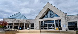
The Fairfax County Public Library system runs the Centreville Regional Library, which is located in Centreville.
Nearby Towns and Communities
- Chantilly-South Riding (1 mile NW)
- Clifton (5 miles SE)
- Fair Lakes (4.5 miles E)
- Manassas (6 miles S)
- Oakton (10 miles E)
See also
 In Spanish: Centreville (Virginia) para niños
 | May Edward Chinn |
 | Rebecca Cole |
 | Alexa Canady |
 | Dorothy Lavinia Brown |


