Point Hope, Alaska facts for kids
Quick facts for kids
Point Hope
Tikiġaq
|
|
|---|---|
| Country | United States |
| State | Alaska |
| Borough | North Slope |
| Incorporated | January 5, 1966 |
| Area | |
| • Total | 5.07 sq mi (13.14 km2) |
| • Land | 5.00 sq mi (12.95 km2) |
| • Water | 0.07 sq mi (0.19 km2) |
| Elevation | 20 ft (6 m) |
| Population
(2020)
|
|
| • Total | 830 |
| • Density | 165.97/sq mi (64.08/km2) |
| Time zone | UTC-9 (Alaska (AKST)) |
| • Summer (DST) | UTC-8 (AKDT) |
| ZIP code |
99766
|
| Area code | 907 |
| FIPS code | 02-61630 |
| GNIS feature ID | 1408110 |
Point Hope (called Inupiaq: Tikiġaq by the local Iñupiat people) is a small city in North Slope Borough, Alaska, United States. It's located in a large area in northern Alaska. In 2020, about 830 people lived there.
Point Hope is very isolated. You can't reach it by road or train. People travel there by boat or by plane, landing at the Point Hope Airport.
Contents
History
A Very Old Home
Point Hope is one of the oldest places in North America where people have lived continuously. Long ago, the Ipiutak people lived here. The local Inuit name for the place is "Tikiġaq," which means "forefinger." This name comes from how the land sticks out into the sea.
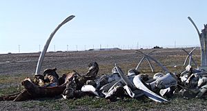
This location was great because the land reaching into the sea brought whales close to the shore. The people built their homes, called semi-subterranean houses, mostly using whale bones and wood they found floating in the ocean.
European Visitors and New Names
The first Europeans to see this area were Russian explorers Mikhail Vasiliev and Gleb Shishmaryov in 1826. They named the cape "Mys Golovnina."
Later, a British captain named Frederick William Beechey renamed it "Point Hope" in honor of Sir William Johnstone Hope.
Modern Times
The first airplane landed in Point Hope in August 1927, flown by Noel Wien.
In 1962, the people of Point Hope successfully stopped a plan called Project Chariot. This project wanted to use nuclear bombs buried underground to create a harbor about 30 miles (48 km) from the village. The people worried about the dangers and managed to stop the project.
Geography
Point Hope is located on a piece of land that sticks out into the Chukchi Sea. This area is at the northwestern end of the Lisburne Peninsula in Alaska. It is just above the Arctic Circle.
The city covers about 6.4 square miles (16.6 square kilometers). Most of this area is land, with a small part being water.
In recent years, global warming has brought changes to Point Hope. One surprising effect is that the melting sea ice might allow for faster internet connections. However, the melting ice and thawing ground also threaten the traditional ways of life for the people, who rely on hunting whales and other activities.
Population
Point Hope first appeared in the U.S. Census in 1880. At that time, 276 Inuit people lived there. The population has changed over the years. In 2010, there were 674 people, and by 2020, the population grew to 830.
Most of the people living in Point Hope are Native American (87.8% in 2010). There are also smaller numbers of White, Black, and other racial groups.
Education
The North Slope Borough School District runs the Tikiġaq School in Point Hope.
Notable people
- John B. Driggs (1852–1914), a doctor who wrote stories about the Inupiat people of Point Hope.
- Caroline Cannon, who won the Goldman Environmental Prize in 2012 for her environmental work. She has also served on Point Hope's city council and was mayor from 1998 to 2001.
See also
 In Spanish: Point Hope para niños


