Poleglass facts for kids
Quick facts for kids Poleglass
|
|
|---|---|
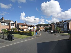
 A street in Poleglass |
|
| Population | 9,105 |
| County | |
| Country | Northern Ireland |
| Sovereign state | United Kingdom |
| Police | Northern Ireland |
| Fire | Northern Ireland |
| Ambulance | Northern Ireland |
| EU Parliament | Northern Ireland |
| UK Parliament |
|
Poleglass (which means "green hollow" in Irish) is an area located in west Belfast, Northern Ireland. The name refers to a specific piece of land, a modern area for voting, and a neighborhood where many working-class families live. This area is mainly known for its strong Irish nationalist identity.
Because Poleglass is close to both Belfast and Lisburn, it has become a popular place for people who travel to work in those cities. This has led to many new houses being built and a quick increase in house prices. Addresses in Poleglass are considered part of Belfast. Also, phone numbers in the area usually start with '90', just like the rest of Belfast.
Contents
Exploring Poleglass's Past
The area we now call Poleglass has a long history of people living there. An ancient circular fort, called a ringfort, was found here. Inside, archaeologists discovered items from the early Christian period. A silver coin from the 13th century was also dug up.
By the early 1900s, Poleglass became part of the "green belt." This was an open, undeveloped area between Belfast and Lisburn. Not many people lived here at that time. Cloona House is a large country home built a few miles from Belfast. It was the childhood home of Beatrice Grimshaw, a famous journalist and adventurer. In 1940, the Ministry of Defence took over the house. It became the home of the main commander of the British Army in Northern Ireland. The Catholic Church bought it in 1980. Since then, it has been used for community projects. Since 2011, the Colin Neighbourhood Partnership has used the house.
How Poleglass Grew
Poleglass was one of several housing projects built after World War II. These projects aimed to help with overcrowding in Catholic areas of west Belfast. The lower Falls Road area, for example, was redeveloped a lot during this time.
Building the Poleglass estate was first suggested in 1973. However, it was located within Lisburn's boundaries. At that time, Lisburn had a large Protestant majority. This led to strong protests from loyalists. Building finally began in 1979. Due to pressure from Unionist politicians and the Ulster Defence Association, the original plan for 4,000 houses was reduced to 1,563. The first parts, Old Colin and Colinmill, opened in 1980. The first residents moved in on November 28, 1980.
By the year 2000, Poleglass had grown to about 2,000 homes. This growth was needed because parts of the Divis flats in the lower Falls area were torn down. The people living there moved to Poleglass. The area is made up of smaller housing estates. These include Glenbank, Glenbawn, Merrion Park, Woodside, Glenwood, Glenkeen, Laurelbank, Old Colin, Colinmill, Springbank, Colinbrook, Colinvale, Ardcaoin, and Brianswell. These estates vary in size and age. Some are very new, while others are original houses from when Poleglass first started.
Important places in Poleglass include the Dairy Farm Shopping Centre, Footprints Women's Centre, the Church of the Nativity, and Colin Glen Forest Park. The youth football team, Colin Valley, plays behind the Olde Mill. They have won many trophies around the world. Most notably, they won the Holland Youth Cup in 1997. The Colin Valley senior football team also plays in Poleglass. They compete in the intermediate sections of the Northern Amateur Football League.
One of the newest additions to Poleglass is 'Páirc Nua Chollann'. This is a new park project in the Southwest Colin area. It was suggested by Sinn Fein representatives on Belfast City Council to meet the needs of young people in Poleglass. The public was asked to help name the park. Most local people voted for the full Irish name, Páirc Nua Chollann. This name received 317 responses, which was 42.4 percent of the public vote. It replaced an earlier idea, the English/Irish name “Páirc Nua Colin.”
Getting Around Poleglass
Poleglass has bus services provided by Translink's Metro system. The 10c Colin Connect is a local service that helps people get to the main bus routes. Services from Poleglass to the City Centre include the 10f, 10x, and 530a. The 530a also connects Poleglass to Lisburn.
The West Belfast Taxi Association also serves Poleglass. They offer a "taxibus" service, which is like a shared taxi. This service connects the city centre with the neighborhoods beyond the Falls Road, including Poleglass.
Neighboring Areas
Poleglass is next to the Stewartstown Road on its east side. This road starts in the Andersonstown area of west Belfast. There are two other main housing areas on this road besides Poleglass: Twinbrook and Lagmore.
Twinbrook has been home to several Irish Traveller families for a long time. Like Poleglass, Twinbrook also has its own electoral ward. This ward is part of the Dunmurry Cross area of Lisburn City Council.
The Lagmore housing estate is south of Poleglass. It is in the Derriaghy area of Lisburn. Lagmore is a newer development than Poleglass or Twinbrook. In fact, houses were still being built there in 2012. Its Catholic church, Christ the Redeemer, became a separate parish from St Luke's Twinbrook only in 1997. The local primary school with the same name opened in 1999.
People from Poleglass
- Belle Steel
- Michael Ferguson
- Frank Pantridge
- Chris Ward
- Beatrice Grimshaw
 | Ernest Everett Just |
 | Mary Jackson |
 | Emmett Chappelle |
 | Marie Maynard Daly |


