Poolesville, Maryland facts for kids
Quick facts for kids
Poolesville, Maryland
|
|||
|---|---|---|---|

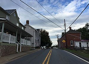
View west along Maryland State Route 107 (Fisher Avenue) at Norris Road
|
|||
|
|||

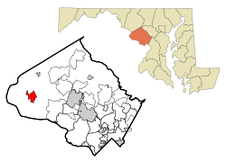
Location of Poolesville, Maryland
|
|||
| Country | |||
| State | |||
| County | Montgomery | ||
| Settled | 1760 | ||
| Incorporated | 1867 | ||
| Government | |||
| • Type | Board of Commissioners/Manager | ||
| Area | |||
| • Total | 3.95 sq mi (10.23 km2) | ||
| • Land | 3.93 sq mi (10.18 km2) | ||
| • Water | 0.02 sq mi (0.05 km2) | ||
| Elevation | 390 ft (120 m) | ||
| Population
(2020)
|
|||
| • Total | 5,742 | ||
| • Density | 1,460.70/sq mi (564.00/km2) | ||
| Time zone | UTC-5 (EST) | ||
| • Summer (DST) | UTC-4 (EDT) | ||
| ZIP code |
20837
|
||
| Area code(s) | 301, 240 | ||
| FIPS code | 24-62850 | ||
| GNIS feature ID | 2391366 | ||
Poolesville is a town in the western part of Montgomery County, Maryland. In 2020, about 5,742 people lived there. It is surrounded by a special area called the Montgomery County Agricultural Reserve. This means there are lots of farms and open spaces around the town. Many people who live in Poolesville travel to Washington, D.C. for work.
The town got its name from two brothers, John Poole Sr. and Joseph Poole Sr. They owned land in the area that became Poolesville. For a long time, the town's official name was "The Commissioners of Poolesville." But in 2010, residents voted to change it to "The Town of Poolesville."
Contents
History of Poolesville
Early Settlement
In 1760, John Poole Sr. and Joseph Poole Sr. bought about 160 acres of land. This land is where Poolesville is today. Thirty-three years later, John Poole Jr. built a log store on land he received from his father. He then sold parts of his land to other business owners. The small settlement grew from there. Poolesville officially became a town in 1867.
The Civil War Years
During the Civil War, leaders of the Union Army saw that the Potomac River was shallow in some spots. This meant enemy soldiers could cross easily into Maryland and threaten Washington, D.C.. So, thousands of Union troops were sent to areas near Poolesville. They watched the river to stop Confederate soldiers from entering Maryland.
In the winter of 1861–1862, around 20,000 Union soldiers were stationed near Poolesville. No major battles happened right in Poolesville. However, the Battle of Ball's Bluff was fought nearby on October 21, 1861. Many Union soldiers from Poolesville were killed in this battle. It was poorly managed by new Union generals.
Confederate soldiers raided Poolesville several times during the war. The Confederate Army also crossed the Potomac near Poolesville in 1862 and 1864. The old Poolesville Methodist Church cemetery has graves of about twenty soldiers. These soldiers either died at Ball's Bluff or from sickness in camp.
Later Developments
The Seneca Schoolhouse was built in Poolesville in 1866. It is a small, one-room schoolhouse made of red sandstone. It was built for the children of stone cutters working at the Seneca Quarry. Today, it is a museum called the Seneca Schoolhouse Museum. Schoolchildren can visit and experience what a school day was like in 1880.
A Buddhist temple called Kunzang Palyul Choling opened in Poolesville in 1985. The Poolesville Historic District was added to the National Register of Historic Places in 1975. This means it's a special area with important historical buildings.
In December 2020, White's Ferry stopped running. This ferry service crossed the Potomac River west of Poolesville. Many people used it to get to work. The ferry stopped because of a legal problem between the ferry owners and a farm called Rockland Farm. As of April 2024, the ferry is still not running.
Geography
Poolesville covers about 3.95 square miles (10.23 square kilometers). Most of this area is land, with a small amount of water.
Poolesville is not located along the main busy roads of Montgomery County. It is separated from the busy suburbs of Washington, D.C., by the agricultural reserve. This reserve is a rural area where new homes and businesses are limited. This helps Poolesville keep its quiet, small-town feel.
Population Information
| Historical population | |||
|---|---|---|---|
| Census | Pop. | %± | |
| 1900 | 236 | — | |
| 1910 | 174 | −26.3% | |
| 1920 | 325 | 86.8% | |
| 1930 | 197 | −39.4% | |
| 1940 | 204 | 3.6% | |
| 1950 | 161 | −21.1% | |
| 1960 | 298 | 85.1% | |
| 1970 | 349 | 17.1% | |
| 1980 | 3,428 | 882.2% | |
| 1990 | 3,796 | 10.7% | |
| 2000 | 5,151 | 35.7% | |
| 2010 | 4,883 | −5.2% | |
| 2020 | 5,742 | 17.6% | |
| U.S. Decennial Census 2010–2020 |
|||
In 2010, there were 4,883 people living in Poolesville. There were 1,602 households, which are groups of people living together. Most households (71%) were married couples. About 45% of households had children under 18 living with them.
The average age of people in Poolesville was about 41.5 years old. About 27.7% of residents were under 18 years old. About 6.1% of residents were 65 years or older.
Education
Poolesville is part of the Montgomery County Public Schools system. There are three schools right in Poolesville:
- Poolesville High School
- John Poole Middle School
- Poolesville Elementary School
Monocacy Elementary School, located in Dickerson, also sends its students to John Poole Middle School.
Transportation
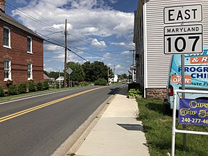
Two main state roads serve Poolesville. Maryland Route 107 goes southeast from the town center. It connects with Maryland Route 28 and leads to Rockville. Maryland Route 109 goes northeast from the town center. It also crosses MD 28 and leads to Interstate 270 in Hyattstown.
Notable People
Many interesting people have connections to Poolesville:
- Tony Lo Bianco: An actor.
- Thomas Plater: A U.S. Congressman from Maryland who died in Poolesville.
- Ann Ritonia: An Episcopal bishop. She used to be the Rector of St. Peter's Parish in Poolesville.
- Elijah V. White: A Confederate commander during the Civil War. He was born near Poolesville.
- Edward Pinkney Wroth: A former Rector of St. Peter's Parish. He later became a bishop in the Episcopal Church.
See also
 In Spanish: Poolesville para niños


