Port Angeles East, Washington facts for kids
Quick facts for kids
Port Angeles East, Washington
|
|
|---|---|

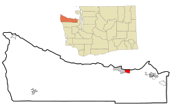
Location of Port Angeles East, Washington
|
|
| Country | United States |
| State | Washington |
| County | Clallam |
| Area | |
| • Total | 4.6 sq mi (12.0 km2) |
| • Land | 3.8 sq mi (9.8 km2) |
| • Water | 0.8 sq mi (2.2 km2) |
| Elevation | 250 ft (80 m) |
| Population
(2020)
|
|
| • Total | 3,159 |
| • Density | 681.8/sq mi (263.3/km2) |
| Time zone | UTC-8 (Pacific (PST)) |
| • Summer (DST) | UTC-7 (PDT) |
| ZIP code |
98362
|
| Area code(s) | 360 |
| FIPS code | 53-55400 |
Port Angeles East is a special kind of community called a census-designated place (CDP). It's located in Clallam County, Washington, in the United States. This area is part of the larger Port Angeles region.
In 2010, about 3,036 people lived here. By 2020, the population grew slightly to 3,159. Even though it's not an official city, many local people call this area the "Gales Addition."
Contents
Exploring Port Angeles East
Port Angeles East is a community that borders the city of Port Angeles. It's known as an unincorporated urban growth area. This means it's a developed area where people live, but it doesn't have its own city government. Instead, it's managed by the county.
Where is Port Angeles East Located?
This community stretches out in a few directions. To the west, it meets the city limits of Port Angeles. To the north, it reaches the Strait of Juan de Fuca and the entrance to Port Angeles Harbor. If you go east, it crosses Morse Creek and goes up to Deer Park Road.
A major road, U.S. Route 101, goes right through Port Angeles East. This highway can take you west into Port Angeles or east about 14 miles to Sequim.
How Big is Port Angeles East?
According to the United States Census Bureau, Port Angeles East covers a total area of about 12.0 square kilometers (which is about 4.6 square miles). Most of this area is land, about 9.8 square kilometers (3.8 square miles). The rest, about 2.2 square kilometers (0.85 square miles), is water. This water area makes up about 18.54% of the total size.
Who Lives in Port Angeles East?
The number of people living in Port Angeles East has changed a bit over the years.
| Historical population | |||
|---|---|---|---|
| Census | Pop. | %± | |
| 2000 | 3,053 | — | |
| 2010 | 3,036 | −0.6% | |
| 2020 | 3,159 | 4.1% | |
In the year 2000, there were 3,053 people living in the area. By 2010, the population was 3,036. The most recent count in 2020 showed that 3,159 people call Port Angeles East home.
The community is made up of different age groups. In 2000, about 21.5% of the people were under 18 years old. About 20.0% were 65 years old or older. The average age in the community was 44 years old.
See also
 In Spanish: Port Angeles East para niños
 | James B. Knighten |
 | Azellia White |
 | Willa Brown |

