
Port Morris, Bronx facts for kids
Quick facts for kids
Port Morris
|
|
|---|---|
|
Neighborhood of the Bronx
|
|

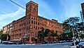
The Clock Tower, former factory now serving residential and commercial tenants
|
|
| Country | |
| State | |
| City | New York City |
| Borough | The Bronx |
| Community District | Bronx 1 |
| Area | |
| • Total | 1.92 km2 (0.742 sq mi) |
| Population
(2011)
|
|
| • Total | 3,523 |
| • Density | 1,833.2/km2 (4,748/sq mi) |
| Economics | |
| • Median income | $38,834 |
| Ethnicity | |
| • Hispanic and Latino Americans | 72.3% |
| • African-American | 24.7% |
| • White | 1.7% |
| • Asian | 0.4% |
| • Others | 1% |
| ZIP Codes |
10451, 10454
|
| Area code | 718, 347, 929, and 917 |
Port Morris is a neighborhood in the southwest Bronx, New York City. It has a mix of factories, warehouses, and homes. It's part of Bronx Community Board 1.
Port Morris is bordered by major roads like the Major Deegan Expressway and Bruckner Expressway. It also touches the East River and Harlem River. Its ZIP Codes are 10451 and 10454. The NYPD's 40th Precinct serves the area.
The southern tip of the West Bronx, called Oak Point, is in Port Morris. This area includes the Oak Point Yard, which is a large train yard. Many parts of the neighborhood are close to subway stations on the IRT Pelham Line.
Contents
History of Port Morris Neighborhood
The history of Port Morris can sometimes be a bit confusing. This is because its exact borders have changed over time. In the past, the name was sometimes used for areas further west, which are now considered part of Mott Haven.
Early Days and Naming Port Morris
There's a story that a British ship carrying gold sank off the coast of Port Morris during the American Revolutionary War. Millions of dollars in gold were supposedly on board, but it has never been found.
The name "Port Morris" comes from Gouverneur Morris Jr.. He was the son of Gouverneur Morris, a famous American leader. In 1842, Gouverneur Morris Jr. built a deep-water port along the East River waterfront. He also built a two-mile (3 km) railroad from Melrose to his family's land by the water. This railroad was later called the Spuyten Duyvil and Port Morris Railroad. It was used for about a hundred years before being abandoned.
Growth and Development in Port Morris

Port Morris is known for its many factory and warehouse buildings. Most of these were built in the mid-to-late 1800s. They were built close to the train yards, like the Oak Point Yard, which is still there today.
Some important early businesses included the R. Hoe Co., which made printing presses. There was also the Cutler & Hammer Tool Works and the Mothers Friend Shirt Waist factory. The Estey Piano Company Factory was another famous business. It's now a city landmark. While many of these old industrial buildings are still standing, they are not used for manufacturing as much anymore.
In the 1870s, the Mott Haven Canal flowed into the western part of Port Morris. It helped industries in the Mott Haven area. However, the canal was slowly filled in over many years. Today, only a small curve in the Harlem River shows where it used to be.
One of the most impressive structures in Port Morris is the northern part of the Hell Gate Bridge. This bridge is supported by large concrete arches built in 1917. There are plans to extend the South Bronx Greenway to Randalls Island. This path would cross the Bronx Kill using the Randall's Island Connector, which opened in 2015.
In the 1970s, many buildings in the area were damaged or destroyed. Later in the century, new businesses started to come back to Port Morris. Many old homes are also being fixed up to provide affordable housing.
Changes and New Plans for Port Morris

In 1997, New York City created the "Port Morris Special Mixed-used District." This allowed homes and businesses to exist in the same area. This led to many old row houses being fixed up. In 2005, the city expanded this district.
In 2017, the city council approved another expansion. This new plan allows for more homes and businesses to be built along the Harlem River.
New Buildings and Community Changes in Port Morris

Port Morris has been changing a lot. Many old warehouses and factories are being turned into modern apartments, often called lofts. The old Estey Piano Corp factory, now known as The Clock Tower, has a restaurant on its ground floor.
Port Morris is becoming a popular place for artists and young professionals. They are looking for more affordable places to live outside of Manhattan. Groups like the New York Restoration Project are working to improve the waterfront. This will create much-needed green spaces for the community. These changes are making Port Morris a growing spot for new restaurants in the South Bronx.
In 2015, Silvercup Studios, a famous film and TV production company, opened a large studio in Port Morris. This studio, called Silvercup North, started operating in 2016.

Some developers tried to rename Port Morris the "Piano District." They bought land to build luxury homes and shops. However, many people in the community did not like this idea.
New buildings continue to be developed in Port Morris. For example, an old factory building was bought and turned into Union Crossing. This is a mixed-use building with offices, shops, and studios. New apartment buildings like The Arches and others along Bruckner Boulevard are also being built.
One large project is "Bankside," which will have seven tall residential towers along the Harlem River. It will also include a public walkway along the river. Other new residential buildings are also planned or under construction.
Port Morris will be an important part of the new Bronx Harlem River Greenway. This greenway will connect different parks and paths, making it easier for people to walk and bike along the river.
People and Population in Port Morris

Port Morris is home to many different groups of people. Most residents are Latin Americans, especially those of Puerto Rican background. There are also many African Americans and a smaller number of white residents.
About half of the people in Port Morris live below the poverty line. This means they receive public assistance to help with living costs. However, the average income in Port Morris is higher than in some other South Bronx neighborhoods. This might be because of the recent changes that have brought more businesses and homes to the area.
According to the 2010 United States Census, the population of Mott Haven and Port Morris combined was 52,413. This was an increase from the year 2000.
Land Use and Buildings in Port Morris
_jeh.jpg)
Port Morris has different types of areas for factories, shops, and homes. The eastern part of Port Morris is mainly used for light industry, warehouses, and distribution centers. The area along Bruckner Boulevard is changing from industrial use to more shops and homes. The western part of Port Morris is quickly becoming a place for many new residential buildings along the Harlem River. Alexander Avenue and Bruckner Boulevard are now the main areas for shops and restaurants.
Important Landmarked Buildings in Port Morris
City Landmarks
Two buildings in Port Morris have been named city landmarks by the New York City Landmarks Preservation Commission.
The Estey Piano Company Factory, now called the "Clock Tower," is at the corner of Lincoln and Bruckner Boulevard. This building reminds us of a time when Port Morris was a major center for making pianos. There is still at least one piano maker in the neighborhood today.
The Bronx Grit Chamber is a building from 1937. It's located at East 132nd Street and St. Ann's Avenue. This building is part of a larger system that cleans wastewater. The Bronx Grit Chamber removes large pieces of waste before the water goes for further cleaning. It is managed by the New York City Department of Environmental Protection.
National Register of Historic Places Listings
The Port Morris Ferry Bridges are also listed on the National Register of Historic Places.
Education in Port Morris
- South Bronx Charter School for International Cultures and the Arts (East 133rd Street and Cypress Pl)
- Per Scholas has its main office at 804 E 138th Street. This organization helps people learn technology skills.
News and Media in Port Morris
The Mott Haven Herald is a news source that covers Mott Haven, Melrose, and Port Morris. It is created by students from the CUNY Graduate School of Journalism. The New York Post newspaper used to have a printing plant in the neighborhood from 2001 to 2021.
Getting Around Port Morris (Transportation)
The following New York City Subway stations serve Port Morris:
- 138th Street–Grand Concourse (4 and 5 train)
- Third Avenue–138th Street (6 <6> trains)
- Brook Avenue (6 train)
- Cypress Avenue (6 train)
The following MTA Regional Bus Operations bus routes serve Port Morris:
- Bx17: to Fordham Plaza via Crotona and Prospect Avenues
- Bx33: to 135th Street station (served by the 2 and 3 train) via 138th Street
- M125: to The Hub or Manhattanville via Willis Avenue and 125th Street
Bruckner Boulevard is the main road through Port Morris. It runs under the Bruckner Expressway.
There have been ideas for a new train station in Port Morris. This station could become a major hub for travel to other parts of New York and Connecticut. It could also connect to Manhattan and LaGuardia Airport. This new station and other planned developments could help the South Bronx grow even more.
Images for kids
-
The Clock Tower, a former factory now with homes and businesses.
