Porthloo facts for kids
Quick facts for kids Porthloo
|
|
|---|---|
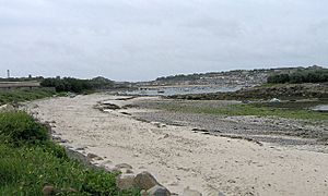
 Porthloo beach |
|
| OS grid reference | SV909114 |
| Civil parish |
|
| Unitary authority | |
| Ceremonial county | |
| Region | |
| Country | England |
| Sovereign state | United Kingdom |
| Post town | ISLES OF SCILLY |
| Postcode district | TR21 |
| Dialling code | 01720 |
| Police | Devon and Cornwall |
| Fire | Isles of Scilly |
| Ambulance | South Western |
| EU Parliament | South West England |
| UK Parliament |
|
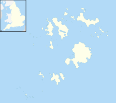
Porthloo (sometimes called Porthlow) is a small village by the sea. It's located on St Mary's island in the beautiful Isles of Scilly, England. The name "Porth Logh" in Cornish means "cove of the deep water inlet."
Porthloo is about half a mile northeast of Hugh Town. It's a popular place for visitors. You can find guest houses, a restaurant, and shops selling gifts and art here.
Contents
Golfing Fun in Porthloo
The only golf club on the Isles of Scilly is just north of Porthloo. It's a great spot for golf lovers!
The course has nine holes, and each hole has two different starting points. The club first opened in 1904. Both the golf course and the clubhouse are open for visitors to enjoy.
Exploring Porthloo Beach
Porthloo Beach faces west, looking out towards the ocean. There are two small islands nearby that you can see at low tide. These are Taylor's Island to the north and Newford Island to the south.
At the top of the beach, there's a small area with sand dunes. The grassy space behind this is used for storing and fixing boats. You might even spot some interesting plants here, like the hairy buttercup. This plant is rare on Scilly.
Special Protection for Porthloo Beach
Porthloo is a very special natural area. It is part of an Area of Outstanding Natural Beauty, which means its landscape is protected. It's also a Geological Conservation Review site because of its important rocks and landforms.
In 1996, Porthloo was named a Site of Special Scientific Interest (SSSI). This means it's a place with important wildlife, plants, or geology that needs to be looked after.
Ancient Layers of Porthloo Beach
The ground at Porthloo Beach holds clues about Earth's past. Scientists have found different layers of soil and rock here. These layers show how the area has changed over thousands of years.
- The top layers are made of fine dust called loess. This dust was blown here by the wind about 18,000 years ago.
- Below that are "head deposits," which are broken rocks and soil. This layer, called the Porthloo Breccia, formed about 30,000 years ago. Plant remains from this time show that the climate was like a cold tundra.
- The oldest layer is a storm beach. This was formed by powerful storms during a warm period about 130,000 years ago.
Porthloo Boat Yard
The Duchy of Cornwall manages a "boat park" in Porthloo. This is a place where boats can be stored on land. It's especially useful for boats that are too big to store anywhere else on St Mary's.
There's a wide ramp, called a slipway, that goes across the beach. This slipway is partly protected by Newford Island. It's used by large barges to load and unload big items, like vehicles and machinery. These items are too large for the main harbor in Hugh Town. You can also find sheds nearby where boats are repaired.
Porthloo on TV
Porthloo has even been on television! The postbox at Porthloo Terrace was once the starting point for a challenge on the TV show Top Gear. The challenge was to see if a car could beat the Royal Mail in delivering a letter all the way to Orkney.
 | John T. Biggers |
 | Thomas Blackshear |
 | Mark Bradford |
 | Beverly Buchanan |


