Poteau, Oklahoma facts for kids
Quick facts for kids
Poteau, Oklahoma
|
|
|---|---|

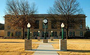
The LeFlore County Courthouse is one of five sites in Poteau listed on the National Register of Historic Places
|
|

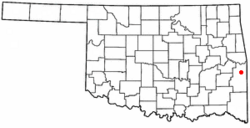
Location of Poteau, Oklahoma
|
|
| Country | United States |
| State | Oklahoma |
| County | Le Flore |
| Area | |
| • Total | 28.73 sq mi (74.40 km2) |
| • Land | 26.61 sq mi (68.91 km2) |
| • Water | 2.12 sq mi (5.49 km2) |
| Elevation | 446 ft (136 m) |
| Population
(2020)
|
|
| • Total | 8,807 |
| • Density | 331.00/sq mi (127.80/km2) |
| Time zone | UTC-6 (Central (CST)) |
| • Summer (DST) | UTC-5 (CDT) |
| ZIP code |
74953
|
| Area code(s) | 539/918 |
| FIPS code | 40-60350 |
| GNIS feature ID | 2411476 |
Poteau (pronounced POH-toh) is a city in Oklahoma, USA. It's the main town, or "county seat," of Le Flore County. In 2020, about 8,807 people lived there.
Contents
Discovering Poteau's Past
How Poteau Got Its Name
French explorers came to this area in 1719. They were led by a man named Bernard de la Harpe. They gave the nearby river its name, the Poteau River. The city of Poteau was founded much later, in 1885. Its name comes from the river.
In the late 1700s, there was a big French outpost at Belle Point, which is now Fort Smith. From there, French traders would travel up the Poteau River. They had a smaller post at the base of Cavanal Mountain. Because of this, the river was called the "Post River," or Poteau River. The outpost was simply called "the post," or "Poteau." The word Poteau is French for "post."
Early Days of the City
The Poteau Chamber of Commerce says the community started in 1885. It was just a few houses and a general store owned by Bud Tate. At that time, Poteau was part of the Choctaw Nation in a place called Sugar Loaf County.
The U.S. government officially made Poteau a town in the Indian Territory on October 8, 1898. The first public stone building, a school, was built that same year.
Growth and Modernization
A railway line was built through Poteau in 1886–1887. It went to Paris, Texas, and included a station in the city. The Poteau post office opened in 1887. Another railroad, the Kansas City, Pittsburg and Gulf Railroad, started serving the town in 1896. This railroad later became part of the Kansas City Southern Railway.
In 1900, the Federal Court for Indian Territory moved to Poteau. The Poteau News newspaper started in 1905. Other improvements happened before Oklahoma became a state. The Bank of Poteau opened in 1901. It became a national bank in 1904. The First Bank of Poteau opened in 1904. A telephone company started in 1904. An electric and water system began in 1906.
After Oklahoma became a state, Governor Charles N. Haskell called Poteau a "city of the first class."
Poteau's Location and Landscape
Poteau is located about 12 miles (19 km) west of the border between Oklahoma and Arkansas. The city sits in a valley below Cavanal Hill. This hill is known as the "World's Highest Hill." It has a sign that says it is 1,999 feet (609 m) tall.
The top of Cavanal Hill is actually 2,385 feet (727 m) above sea level. It rises 1,960 feet (597 m) above the Poteau River on the east side of Poteau. In the early 1900s, a lot of coal was mined here. A railway, called the Poteau and Cavanal Mountain Railroad, served these mines.
Poteau's Weather
Poteau has a warm climate. It shares the record for the highest temperature ever recorded in Oklahoma.
| Climate data for Poteau, OK | |||||||||||||
|---|---|---|---|---|---|---|---|---|---|---|---|---|---|
| Month | Jan | Feb | Mar | Apr | May | Jun | Jul | Aug | Sep | Oct | Nov | Dec | Year |
| Record high °F (°C) | 84 (29) |
85 (29) |
92 (33) |
95 (35) |
100 (38) |
110 (43) |
113 (45) |
120 (49) |
110 (43) |
101 (38) |
88 (31) |
83 (28) |
120 (49) |
| Mean daily maximum °F (°C) | 52.5 (11.4) |
57.0 (13.9) |
65.1 (18.4) |
75.0 (23.9) |
81.7 (27.6) |
89.7 (32.1) |
95.3 (35.2) |
95.3 (35.2) |
88.2 (31.2) |
78.1 (25.6) |
64.5 (18.1) |
55.4 (13.0) |
74.8 (23.8) |
| Mean daily minimum °F (°C) | 29.4 (−1.4) |
33.5 (0.8) |
41.2 (5.1) |
50.7 (10.4) |
58.3 (14.6) |
66.5 (19.2) |
70.4 (21.3) |
69.6 (20.9) |
62.2 (16.8) |
51.1 (10.6) |
39.8 (4.3) |
32.8 (0.4) |
50.5 (10.3) |
| Record low °F (°C) | −7 (−22) |
−7 (−22) |
7 (−14) |
21 (−6) |
34 (1) |
46 (8) |
49 (9) |
49 (9) |
33 (1) |
23 (−5) |
10 (−12) |
−6 (−21) |
−7 (−22) |
| Average precipitation inches (mm) | 2.52 (64) |
3.02 (77) |
3.65 (93) |
4.63 (118) |
5.89 (150) |
3.89 (99) |
3.42 (87) |
3.00 (76) |
3.84 (98) |
3.53 (90) |
3.73 (95) |
3.02 (77) |
44.14 (1,124) |
| Average snowfall inches (cm) | 2.1 (5.3) |
2.3 (5.8) |
0.3 (0.76) |
0 (0) |
0 (0) |
0 (0) |
0 (0) |
0 (0) |
0 (0) |
0 (0) |
0.1 (0.25) |
0.6 (1.5) |
5.4 (13.61) |
| Source: http://www.wrcc.dri.edu/cgi-bin/cliMAIN.pl?ok7246 | |||||||||||||
Who Lives in Poteau?
| Historical population | |||
|---|---|---|---|
| Census | Pop. | %± | |
| 1900 | 1,182 | — | |
| 1910 | 1,830 | 54.8% | |
| 1920 | 2,679 | 46.4% | |
| 1930 | 3,169 | 18.3% | |
| 1940 | 4,020 | 26.9% | |
| 1950 | 4,776 | 18.8% | |
| 1960 | 4,428 | −7.3% | |
| 1970 | 5,500 | 24.2% | |
| 1980 | 7,089 | 28.9% | |
| 1990 | 7,210 | 1.7% | |
| 2000 | 7,939 | 10.1% | |
| 2010 | 8,520 | 7.3% | |
| 2020 | 8,807 | 3.4% | |
| U.S. Decennial Census 2014 Estimate |
|||
Poteau's Population in 2020
In 2020, there were 8,807 people living in Poteau. These people lived in 3,199 households. About 2,224 of these households were families.
| Race | Num. | Perc. |
|---|---|---|
| White | 5,407 | 61.39% |
| Black or African American | 102 | 1.16% |
| Native American | 1,137 | 12.91% |
| Asian | 82 | 0.93% |
| Pacific Islander | 17 | 0.19% |
| Other/Mixed | 882 | 10.01% |
| Hispanic or Latino | 1,180 | 13.4% |
Fun and Games in Poteau
Twyman Park is a great place to visit. It has picnic tables, playgrounds, and tennis courts. There's also a small pond and a swimming pool.
Other places for fun include the Poteau Area Recreational Complex. This is where sports events are held. You can also visit Bill J. Barber Park and Dunbar Park.
Lake Wister and the Lake Wister State Park are also located in Poteau. They offer many outdoor activities.
Learning in Poteau
Poteau Public Schools
The Poteau Public School System has several schools. These include Poteau Primary School, Poteau Upper Elementary School, Pansy Kidd Middle School, and Poteau Senior High School. Pansy Kidd Middle School is named after Pansy Ingle Kidd. She was a teacher in Poteau for over 40 years. People called her the "Dean of Poteau's Teachers."
In 1955, a black veterinarian named Dr. John Montgomery asked the Poteau Public School Board to end segregation in schools. The board agreed. This made Poteau the first city in Oklahoma to allow African American students to learn alongside white students in its schools.
Colleges and Training
Carl Albert State College is in Poteau. It used to be called Poteau Junior College. It is one of 13 state colleges in Oklahoma.
Kiamichi Technology Center also has a branch in Poteau. This center is part of the Oklahoma CareerTech System. It helps people learn skills for different jobs.
Getting Around Poteau
Roads and Highways
Poteau is served by several major roads. These include US Routes 59, 270, and 271. You can also use State Highways 83 and 112 to get around.
Air Travel
The Robert S. Kerr Airport (KRKR) is about 2 miles (3.2 km) south of town. It has a paved runway that is 4,007 feet (1,221 m) long and 75 feet (23 m) wide.
Safety and Law Enforcement
The Le Flore County Sheriff's office is located in Poteau. It has highway patrol officers and an inspector to help keep the community safe.
Famous People from Poteau
Many interesting people have connections to Poteau:
- Rilla Askew – a writer
- Roberta Bell – an artist
- Jackson Burns – an actor, writer, producer, and stunt coordinator
- Kenneth Corn – a former state senator and representative for Oklahoma
- Ron Fortner – a radio and television anchor
- Argus Hamilton – a comedian and national newspaper columnist
- Billy Hoffman – a country music singer who grew up in Poteau
- Robert S. Kerr – a U.S. senator who owned a home and cattle ranch nearby
- Mick Thompson – the current Oklahoma State Banking Commissioner
See also
 In Spanish: Poteau (Oklahoma) para niños

