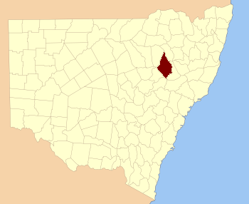
Pottinger County facts for kids
Quick facts for kids PottingerNew South Wales |
|||||||||||||||
|---|---|---|---|---|---|---|---|---|---|---|---|---|---|---|---|

Location in New South Wales
|
|||||||||||||||
|
|||||||||||||||
Pottinger County is a special kind of land area in New South Wales, Australia. It's one of 141 such areas, used mainly for keeping track of land ownership and boundaries. You can find it southwest of the Namoi River and Mooki River, close to the town of Gunnedah.
This county was named after Sir Henry Pottinger, who lived from 1789 to 1856. He was an important person who became the very first Governor of Hong Kong.
What is a Cadastral Division?
A cadastral division is like a historical way of dividing up land. Think of it as an old map system that helps people know exactly where one piece of land ends and another begins. These divisions are not used for local government today, but they are still important for understanding land records and history.
Exploring the Parishes of Pottinger County
Inside Pottinger County, there are smaller land areas called parishes. These are even smaller divisions of land, also used for mapping and land records. Each parish is part of a larger local government area (LGA), which is how Australia divides up its regions for local councils and services.
Here are a few examples of parishes you can find in Pottinger County:
 | Jackie Robinson |
 | Jack Johnson |
 | Althea Gibson |
 | Arthur Ashe |
 | Muhammad Ali |

