Prattsburgh, New York facts for kids
Quick facts for kids
Prattsburgh, New York
|
|
|---|---|
| Country | United States |
| State | New York |
| County | Steuben |
| Area | |
| • Total | 51.72 sq mi (133.94 km2) |
| • Land | 51.67 sq mi (133.82 km2) |
| • Water | 0.05 sq mi (0.13 km2) |
| Elevation | 1,939 ft (591 m) |
| Population
(2020)
|
|
| • Total | 1,985 |
| • Estimate
(2021)
|
1,968 |
| • Density | 38.77/sq mi (14.97/km2) |
| Time zone | UTC-5 (Eastern (EST)) |
| • Summer (DST) | UTC-4 (EDT) |
| ZIP code |
14873
|
| Area code(s) | 607 |
| FIPS code | 36-59718 |
| GNIS feature ID | 0979395 |
Prattsburgh is a small town located in Steuben County, New York, in the United States. In 2020, about 1,985 people lived there. You can find Prattsburgh in the northeast part of Steuben County, just north of the town of Bath.
Contents
The History of Prattsburgh
Prattsburgh was officially created in 1813. It was formed from a nearby town called Pulteney.
How Prattsburgh Got Its Name
The town is named after an early settler, Joel Pratt. He arrived in the area around 1799 to buy land. Other settlers started to arrive and make homes here in 1801.
Early Education and Transportation
An old school called the Franklin Institute was in Prattsburgh around 1812.
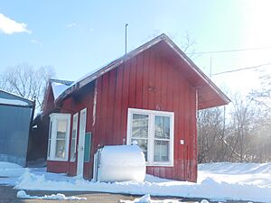
For many years, from about 1889 to 1961, Prattsburgh had its own railroad. This railroad was called the Kanona & Prattsburgh Railroad. It connected Prattsburgh to the main Erie Railroad line at Kanona. This made it easier for people and goods to travel.
Exploring Prattsburgh's Geography
Prattsburgh covers a total area of about 51.7 square miles (133.9 square kilometers). Most of this area is land, with only a tiny bit being water.
Location and Borders
The northern border of Prattsburgh is also the border between Steuben County and Yates County. This means Prattsburgh is right on the edge of two different counties.
Important Roads and Elevation
New York State Route 53 is a key highway that runs north and south through the town. It helps people travel to and from Prattsburgh. The town is also located at a higher elevation than many other parts of Steuben County.
Prattsburgh's Population Over Time
| Historical population | |||
|---|---|---|---|
| Census | Pop. | %± | |
| 1820 | 1,377 | — | |
| 1830 | 2,399 | 74.2% | |
| 1840 | 2,455 | 2.3% | |
| 1850 | 2,786 | 13.5% | |
| 1860 | 2,790 | 0.1% | |
| 1870 | 2,479 | −11.1% | |
| 1880 | 2,349 | −5.2% | |
| 1890 | 2,170 | −7.6% | |
| 1900 | 2,197 | 1.2% | |
| 1910 | 1,834 | −16.5% | |
| 1920 | 1,663 | −9.3% | |
| 1930 | 1,421 | −14.6% | |
| 1940 | 1,364 | −4.0% | |
| 1950 | 1,353 | −0.8% | |
| 1960 | 1,448 | 7.0% | |
| 1970 | 1,523 | 5.2% | |
| 1980 | 1,657 | 8.8% | |
| 1990 | 1,894 | 14.3% | |
| 2000 | 2,064 | 9.0% | |
| 2010 | 2,085 | 1.0% | |
| 2020 | 1,985 | −4.8% | |
| 2021 (est.) | 1,968 | −5.6% | |
| U.S. Decennial Census | |||
According to the census from 2000, there were 2,064 people living in Prattsburgh. These people lived in 809 households. About 35.5% of these households had children under 18 living there.
The population was spread out in terms of age. About 28% of the people were under 18 years old. The average age in the town was 37 years.
Communities and Locations in Prattsburgh
The Town of Prattsburgh includes a few smaller communities and specific locations:
- Beans Station – This spot is located at the southern edge of the town, right on NY-53.
- Daball Corners – You can find this area north of the main Prattsburgh hamlet, along County Road 122.
- Ingleside – This is a small hamlet in the northwest part of the town, also on NY-53.
- Prattsburgh – This is the main village-like area, or hamlet, in the east-central part of the town. It's also located on NY-53. Prattsburgh used to be an official village, but it changed its status in 1972. In 2010, its population was 656 people.
Famous People from Prattsburgh
Some notable people have come from Prattsburgh:
- Robert B. Van Valkenburgh – He was a former member of the U.S. Congress and an army officer.
- Narcissa Whitman (1808-1847) – She was a missionary who traveled to the American West.
See also
 In Spanish: Prattsburgh para niños
 | Misty Copeland |
 | Raven Wilkinson |
 | Debra Austin |
 | Aesha Ash |


