
Prestonville, Brighton facts for kids
.JPG)
Prestonville is a mostly residential area in the northwest part of Brighton, a city in England. It sits on a long, narrow hill between the main railway line to London and Dyke Road. These are two important routes that go north from the center of Brighton. People started building homes here in the 1860s, and development continued north for about 60 years. The area is known for its homes, which are often for middle-class families, and for its great views looking east across the city. Prestonville has two Anglican churches, one at each end of the area. Several buildings here are also officially protected because of their history or special design.
Brighton and Hove City Council says that Prestonville is an "inner suburb" built before 1914. This means it's an older neighborhood close to the city center. Its streets, buildings, and overall feel have been kept very well, giving it a "strong sense of place." You can find "high-quality" Victorian buildings among the houses. Some streets even have special "railway suburb" homes. These were built by the London, Brighton and South Coast Railway company. They wanted to rehouse people who lost their homes when the company expanded its train yard near Brighton station. While this plan didn't fully work, it left behind "good-quality housing" that is still here today.
Contents
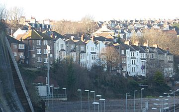
Where is Prestonville?
.JPG)
Prestonville is on a sloping hill on the west side of a valley. The London Road and the main railway line run through this valley. The land goes steeply downhill from Dyke Road. Dyke Road is a very old path that used to lead to Devil's Dyke on the South Downs. Today, it's a major road in the city. In the past, Dyke Road was the border between the old areas of Hove and Preston. Later, when Preston became part of Brighton, Dyke Road marked the edge between the towns of Hove and Brighton. The center of Brighton is about 1.2 miles (2 km) to the southeast. Central Hove is to the southwest.
Starting from the south and going around, Prestonville's borders are Seven Dials, Chatham Place, Howard Place, the Brighton Main Line (between Brighton and Preston Park stations), Tivoli Crescent North, and Dyke Road. Old Shoreham Road, a big road at the south end of Prestonville, was the northern border of Brighton until 1873. This meant it was also the border between Brighton and Preston.
Prestonville has many mature trees planted along its streets, which is nice. However, there aren't many open green spaces directly within the area. Luckily, Dyke Road Park and Preston Park are close by. You can get great views looking east and southeast across the city from many streets, especially in the northern part. When Prestonville was built in the 1800s, even though some parts were very close to Brighton railway station and its train workshops, the smoke and pollution didn't bother residents much. This was because the wind usually blew the smoke away in the opposite direction.
Prestonville's Past

The old area of Preston was a large farming area, about 1,300 acres (530 ha). It was cut through by the Wellesbourne valley and was the first area north of both Hove and Brighton. Old Shoreham Road, which is now a main road in southern Prestonville, used to be its border. St Peter's Church (the old church for the area) and Preston Manor were on the east side of the valley. Dyke Road, which led to Devil's Dyke on the South Downs, formed the western border.
Preston became part of Brighton in 1868 and was fully added to the town in 1873. This happened as Brighton grew quickly as a popular seaside resort. Prestonville's growth helped the population of Preston increase a lot. In 1841, there were 756 people, but 30 years later, there were 2,470!
Before Preston became a town, maps showed that most of the land between Dyke Road and where the railway would be built belonged to Thomas Stanford and was farmed by his son. A windmill called Port Hall Mill stood near a house called Port Hall from 1795 to 1887. Another mill, Preston Mill, was on the site of Old Mill Works in Highcroft Villas from 1797 to 1881. Before 1797, this mill was actually on Brighton seafront! Two paintings at Preston Manor show 36 oxen moving it up the hill to its new spot.
Homes started to spread north into this area in the 1840s, after Brighton railway station opened. Areas like West Hill and Seven Dials were built up first. Then, between 1848 and 1858, streets like Chatham Place, Russell Crescent, Howard Terrace, and the southern part of Prestonville Road were created. Old Shoreham Road hadn't been reached yet. North of this road was farmland on the west side of the Wellesbourne valley. This land was cut off from Preston village, its church, and manor house by the new railway line.
A developer named Daniel Friend bought this land in the 1860s and started building homes for middle-class families. He bought about 6.5 acres (2.6 ha) from the London and Brighton Railway company. The railway company had bought this land earlier, around 1839, from William Stanford. In the early days of railways, it was common for companies to buy more land than they needed and then sell the extra land for building houses.
.JPG)
The first streets built north of Old Shoreham Road were the northern part of Prestonville Road, Prestonville Terrace, Hamilton Road (where the Prestonville Arms pub is), Hamilton Terrace, Brigden Street, and the lower part of Stanford Road. These were all built between 1865 and 1869. York Grove was built a bit earlier, around 1860, on the site of the old New England Farm buildings. The main farmhouse, built before 1820, was kept and is now number 26 York Grove.
Building spread north along Dyke Road during the 1870s, reaching Highcroft Villas, which was built up from 1880. The 1880s was a big time for building in Prestonville. The land around an 18th-century house called Port Hall was developed with homes. Streets like Coventry Street, Exeter Street, Port Hall Street, Upper Hamilton Road, and the northern part of Stanford Road were built then. Four more roads—Buxton, Chatsworth, Lancaster, and Stafford—were built in the 1890s. Further north, the areas near Dyke Road, Highcroft Villas, The Drove, and the railway line were finished by the late 1890s. The area stretching north towards Tivoli Crescent North was completed just before World War I started. Millers Road, one of these newer roads, was named after the old Preston Mill. The Dyke Tavern pub on Dyke Road was originally called the Windmill Inn, also named after a mill.
In 1871, a survey showed that many early residents of Prestonville worked for the railway at Brighton station or the nearby train workshops. Other jobs included teachers, managers, a tax inspector, a retired admiral, a bookseller, and a shop assistant. Two houses on Hamilton Road were used as an orphans' home and a private school. At this time, many houses were rented. Moving from one street to another could even mean moving up in social status! Brigden Street, Prestonville Terrace, Hamilton Road, and Stanford Road were seen as having increasing social standing.
Many houses on Compton Road and Inwood Crescent were built by the London, Brighton and South Coast Railway (LBSCR) around 1900. They were meant for families who had to move from streets around Brighton station. In 1898, the LBSCR got permission to buy 171 houses and knock them down to make the Brighton station goods yard bigger. The area was cleared between 1901 and 1904. The company also bought some houses privately, meaning 225 families had to move. The law that allowed the company to buy these homes also made them rehouse the people elsewhere in Brighton.
The company bought land from the Stanford family in 1901 and 1903 for £5,600. They built 123 houses and flats of different styles. These homes were good quality and bigger than the terraced houses they replaced. However, as a rehousing plan, it didn't work very well because few of the displaced people actually moved there. The railway companies (and later British Railways) owned these houses until 1965.
During World War II, on May 25, 1943, four houses on Compton Road were bombed, and one person died. New flats now stand where numbers 20–26 used to be. Another bomb just missed Highcroft Villas, landing on the railway line below. Prestonville didn't change much after the war, though some other houses were replaced by blocks of flats. For example, Hove Villa, built in 1840, was knocked down in 1972. Two blocks of flats called Prestonville Court were built in its place.
People and Community
.jpg)
In 2001, Prestonville's population was estimated to be 5,616 people. There were about 56 homes per hectare. Of the homes, 31% were terraced houses, 8% were semi-detached (two homes joined together), 8% were detached (stand-alone homes), and 53% were flats of different types. Many flats in the area are in houses that have been converted into multiple apartments. In 2001, 66% of homes were owned by the people living in them, and 34% were rented, mostly from private landlords.
For local government, Prestonville is split between Preston Park ward and Withdean ward. These are two of the 21 local government areas in Brighton and Hove. The border between them runs along Highcroft Villas.
The Prestonville Community Association is a local group that works to help the community. In 2012, St Luke's Church decided to sell Exeter Street Hall. Community members formed a special group to buy it. They wanted to make sure it stayed a place for the community to use. The group offered to sell shares in the building to local residents and others who were interested.
Prestonville has Stanford Junior School for younger children. However, the closest pre-school facilities are a mile away, and there isn't a secondary school directly in the area. Students usually go to Dorothy Stringer School and Varndean School.
Important Buildings
_(3).JPG)
_(February_2014)_(3).jpg)
St Luke's Church is a very noticeable building at the corner of Old Shoreham Road and Stanford Road in southern Prestonville. This Anglican church was built in 1875 and designed by John Hill. Its church hall on Exeter Street, built in 1884, is in the Gothic Revival style and still has its original red-brick look.
The Church of the Good Shepherd is at the corner of Dyke Road and The Drove in northern Prestonville. It was built between 1920 and 1922 and designed by Edward Prioleau Warren. Both the church and the small brick walls around it are Grade II-listed, meaning they are protected buildings. It's a brown-brick building with a simple Gothic Revival style. A tower and an extra section were added between 1925 and 1927. The church hall opened in 1936. The church was built to honor Rev. Gerald Moor, a former Vicar of Preston.
The Al-Quds Mosque was started in the 1970s. A group of Muslims visiting the area gave money to create an Islamic center and mosque. The community bought a converted house that used to be a nursery school.
.JPG)
Two other Grade II-listed buildings are further south on Dyke Road. The Booth Museum of Natural History was built in 1874. It was made to hold the large collection of British birds, insects, and other items gathered by naturalist Edward Booth. It started as a museum in 1890. Many more collections have been added, and in 1998, the museum was named a "collection of national importance." The building itself is long and low, with an Italianate and Romanesque Revival style. It uses bricks of different colors.
At the corner of Port Hall Road and Dyke Road is Port Hall. This house was built in the early 1800s. It has interesting arched doorways and windows. Above the first floor, there's a wall with battlements (like a castle) and a decorative strip. The name "Port Hall" is carved into a panel on this wall.
,_Prestonville,_Brighton_(December_2013)_(2).JPG)
Prestonville has two important school buildings. The Grade II-listed Stanford Road School is a primary school. It was built in 1893 as one of several "distinguished" schools designed by Thomas Simpson and his son Gilbert Murray Simpson. The outside of the school is very fancy, using brown and red brick, stone, tiles, and plaster. It has detailed arched windows, many gables (pointed roof sections), a clock tower, and a wooden bell-cot (a small structure for a bell). The inside still has its original layout and features.
At the corner of Old Shoreham Road and Dyke Road is the Brighton Hove & Sussex Sixth Form College (BHASVIC). This building is on Brighton and Hove City Council's list of locally protected buildings. This "splendid" former grammar school was designed in 1913 by S.B. Russell. It was expanded in 1934–35. In 2005, ramps were added to make it easier for everyone to access. It's a Neo-Georgian and Queen Anne-style building with lots of red brick. It has wings connected to a central part by staircases with round windows. It sits on a very noticeable corner. The college still has its original iron gates, which feature the symbols of Hove and Brighton.
The Quebec Army Reserve Centre at 198 Dyke Road is home to a part of the Princess of Wales's Royal Regiment. There's also an Army Cadet Force hut there, where the Brighton Army Cadets meet. The Quebec Army Reserve Centre was built during World War II as an army training hall. After the war, the Territorial Army moved their headquarters there from smaller places in central Brighton.
Getting Around Prestonville
_at_Dyke_Road,_Prestonville,_Brighton_(26-08-2013).JPG)
Prestonville is very convenient for train travel. Brighton railway station is close to the southeast corner of the area. You can see its impressive curved train shed from some of the nearby streets. At the northeast corner of Prestonville is Preston Park railway station. This is the first station outside Brighton on the main line to London. There's an entrance to this station at the corner of Woodside Avenue and Tivoli Crescent North. The railway line runs much lower than the hill and forms the eastern edge of Prestonville.
Bus routes run along Dyke Road, operated by the Brighton & Hove Bus Company. Route 27 goes between Westdene and Saltdean, passing through Brighton station and Old Steine. Some services on routes 14 and 14C also use Dyke Road on their way between Hangleton and Peacehaven. The weekend-only Route 77 bus goes between Brighton Pier and Devil's Dyke about every 45 minutes, along the entire length of Dyke Road. Bus trips to the center of Brighton take about 10 minutes.
Fewer people own cars in Prestonville compared to the rest of the city. Also, 22% of people walk to work. Dyke Road often gets crowded during busy times. The section of Old Shoreham Road that goes under the New England railway bridge is another spot where traffic can slow down. It's not easy to cross the railway line to the east. Besides the bridge at the south end, there's the Dyke Road Drive overbridge in the middle and a narrow tunnel further north.
In April 2013, Brighton and Hove City Council started making some areas 20 mph zones. The southern part of Prestonville, up to Highcroft Villas, was included in this first phase. The rest of Prestonville, except Dyke Road, is planned to be included later.
Famous People from Prestonville
The inventor Magnus Volk lived at 128 Dyke Road towards the end of his life. Sculptor and artist Eric Gill was born at 32 Hamilton Road in 1882 and spent his childhood nearby at 53 Highcroft Villas. Theatre manager Charles B. Cochran was born at 15 Prestonville Road in 1872.
Images for kids
- Examples of housing in Prestonville
-
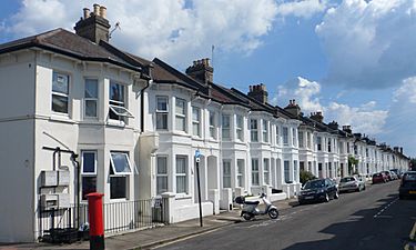
Terraced housing on Exeter Street
-
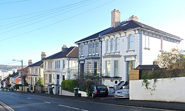
Villas on Old Shoreham Road (south side)
-
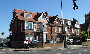
Edwardian houses at Dyke Road–The Drove junction
-
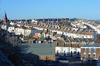
The southern part of Prestonville
-
Millers Road, backing on to the railway
.JPG)
.JPG)
.JPG)
.JPG)
.JPG)
