
Peacehaven facts for kids
Quick facts for kids Peacehaven |
|
|---|---|
 The Meridian Monument |
|

Peacehaven
|
|
| Area | 5.2 km2 (2.0 sq mi) |
| Population | 14,067 (Parish-2011) |
| • Density | 6,621/sq mi (2,556/km2) |
| OS grid reference | TQ407013 |
| • London | 49 miles (79 km) N |
| District |
|
| Shire county | |
| Region | |
| Country | England |
| Sovereign state | United Kingdom |
| Post town | PEACEHAVEN |
| Postcode district | BN10 |
| Dialling code | 01273 |
| Police | Sussex |
| Fire | East Sussex |
| Ambulance | South East Coast |
| EU Parliament | South East England |
| UK Parliament |
|
| Website | Town Council website |
Peacehaven is a town in East Sussex, England. It is located on top of chalk cliffs, about six miles east of Brighton. The town is special because the Prime Meridian line, which divides the Earth into east and west, crosses the English south coast right here. Peacehaven is next to Telscombe Cliffs, which is a separate town.
Contents
Peacehaven's Past: A Look at History
Ancient Times and Early Settlements
Long, long ago, about 3,500 years ago, people lived in the area that is now Peacehaven. There's a Bronze Age burial mound, called a barrow, very close to the cliff top. This shows that people were here a very long time ago. In 2007, during an excavation for new homes, archaeologists found lots of evidence of a prehistoric settlement from the Bronze and Iron Ages.
How Peacehaven Began
Peacehaven was started in 1916 by a businessman named Charles Neville. He bought land and created a company to build the town. To get people interested, he held a competition in newspapers across England to name the new development. The winners chose "New Anzac-on-Sea" to honor the ANZAC soldiers who fought in the Battle of Gallipoli.
Later, a newspaper called the Daily Express sued Neville. They said his competition was a trick because he offered "free" plots of land but then charged a fee to get them. The newspaper won the case. However, all this news actually made more people hear about Peacehaven! Neville's idea was to sell small pieces of land cheaply so people could build their own homes.
Less than a year later, on February 12, 1917, the town's name was changed to Peacehaven.
Life in Early Peacehaven
Many people believe the town was first made for soldiers returning from World War I to help them recover. This isn't fully proven, but Charles Neville advertised Peacehaven as a perfect, peaceful place. He said the sea air and simple life would be good for health. The land was also cheap, so working-class families from cities started buying plots. They built simple homes for weekends and holidays.
These early homes were often temporary, made from whatever materials were available. Some were old railway carriages, and others were built from old army huts. This way of building was called the "plotlands movement." People felt free living simply, away from the busy city.
By 1924, about 3,000 people lived in Peacehaven. Over time, the local council added water and electricity, so people began building stronger houses. After World War II, the council made plans to improve areas along the coast road.
Historic Buildings in Peacehaven
Peacehaven has a few old buildings. Halcombe Farm House was built in the 1600s, and Hoddern Farm House is from the 1700s. Another old building is the Shepherds Cot, which is now part of a private home. This tiny cabin was built around the 1880s to shelter shepherds during lambing season.
The famous singer and comedian Gracie Fields also bought a home in Peacehaven, with views of the sea.
Peacehaven's Location and Landscape
Peacehaven is on flat land near the coast, about 40 to 50 meters (130 to 160 feet) above sea level. You can reach the pebble beach below the cliffs by stairs or a concrete path.
There are several green spaces along the main road (A259) and the cliffs. One of these is called The Dell. A cinema used to be here, but now it hosts events like car boot sales, fireworks, and a yearly carnival.
Town Layout and the Meridian Line
Charles Neville was inspired by the American way of planning towns, using a grid system. Originally, Peacehaven had only "Roads" and "Avenues." Most "Roads" ran east to west, and "Avenues" ran north to south, crossing the main South Coast Road (A259).
The town still has its original grid layout, with rectangular plots of land on both sides of the main road. Old photos from the 1930s clearly show this grid pattern.

The cliffs at Peacehaven are part of a special scientific area called the Brighton to Newhaven Cliffs. These cliffs are important for geology because they contain many fossils. They also have interesting plants and animals.
A tall stone monument, called an obelisk, marks the exact spot where the Prime Meridian crosses the coast. It is 3.5 meters (11.5 feet) tall and was put up in 1936. It has been moved twice because the cliffs are slowly eroding away.
How Peacehaven is Governed
Peacehaven has different levels of government that help run the town.
Local Town Council
The lowest level of government is the Peacehaven Town Council. They are in charge of things like local planning, roads, and other town facilities. The council has 17 elected members from three areas: North, West, and East Peacehaven.
District and County Councils
The next level is the Lewes District Council. They handle bigger things like collecting council tax, environmental health, and local elections. Peacehaven has six councillors on the district council.
The county council for East Sussex is responsible for even larger services, such as education, libraries, social services, and transportation. Peacehaven and the nearby Telscombe parish together elect two councillors to the county council.
National Government
For national elections in the UK, Peacehaven is part of the Brighton Kemptown and Peacehaven area. This area elects one Member of Parliament (MP) to the UK Parliament. In the 2024 election, Chris Ward from the Labour Party won this seat.
Shopping and Local Businesses

Peacehaven has a shopping center called the Co-operative Meridian Shopping Centre. There's also a leisure center, several pubs, coffee shops, and restaurants in the town.
Peacehaven is also "twinned" with two other towns: Épinay-sous-Sénart in France and Isernhagen in Germany. This means they have special friendly relationships and sometimes exchange visits.
Places of Worship
There are four churches in Peacehaven and one in Telscombe Cliffs. The Church of the Ascension is an Anglican church. The Roman Catholic Church is called the Immaculate Conception. There is also a Jehovah's Witnesses' Kingdom Hall and an Evangelical church.
Schools and Learning
Peacehaven has one secondary school, Peacehaven Community School. There are also three primary schools: Peacehaven Heights Primary School, Meridian Primary School, and Telscombe Cliffs Primary School and Nursery. The library in the Meridian Centre offers various learning activities for children and adults.
News and Media
Local news and TV shows for Peacehaven come from BBC South East and ITV Meridian. You can listen to local radio stations like BBC Radio Sussex and Seahaven FM. The town is also served by local newspapers, Sussex Express and The Argus.
Sports and Fun Activities
Peacehaven has a football club called Peacehaven & Telscombe F.C. They play at the Sports Park and host football tournaments for young players. There's a small leisure center, a bowls club, and dance schools. You can also find football and martial arts clubs.
Many groups meet in Peacehaven, like the Women's Institute.
In 2015, a new recreation area called 'The Big Parks Project' was finished. It has a cafe, playgrounds, new bike paths, a skate park, and sports facilities. This project has won many awards!
Peacehaven in Books and Movies
Peacehaven has appeared in several stories and films:
- The town is mentioned in Graham Greene's 1938 novel Brighton Rock.
- The 1979 film Quadrophenia ends with the main character, Jimmy, stealing a scooter and heading to Peacehaven Cliffs.
- In the TV thriller series The Level, a car is pushed over the cliff in Peacehaven.
- In the BBC soap opera EastEnders, a character's ashes were scattered over the cliffs in Peacehaven because she had happy childhood holidays there.
Music from Peacehaven
The punk band Peter and the Test Tube Babies formed in Peacehaven in 1978.
Images for kids
-
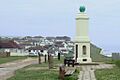
The Meridian Monument
-
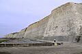
The chalk cliffs at Peacehaven
-
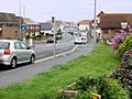
The A259 running through the town
See also
 In Spanish: Peacehaven para niños
