
Telscombe facts for kids
Quick facts for kids Telscombe |
|
|---|---|
 |
|

Telscombe
|
|
| Area | 4.7 km2 (1.8 sq mi) |
| Population | 7,477 (2011) |
| • Density | 3,868/sq mi (1,493/km2) |
| OS grid reference | TQ403022 |
| • London | 48 miles (77 km) N |
| District |
|
| Shire county | |
| Region | |
| Country | England |
| Sovereign state | United Kingdom |
| Post town | PEACEHAVEN |
| Postcode district | BN10 |
| Post town | BRIGHTON |
| Postcode district | BN2 |
| Post town | LEWES |
| Postcode district | BN7 |
| Dialling code | 01273 |
| Police | Sussex |
| Fire | East Sussex |
| Ambulance | South East Coast |
| EU Parliament | South East England |
| UK Parliament |
|
| Website | Town council web site |
Telscombe is a town and civil parish in East Sussex, England. It is located in the Lewes District. Telscombe is made up of three separate areas. These areas are divided by an open, grassy area called Telscombe Tye.
Telscombe village is a tiny village located on the South Downs. It is about 10 kilometers (6 miles) south of Lewes. The village has a church that is very old, dating back to the 10th century. Fewer than 50 people live in Telscombe village.
The parish of Telscombe stretches from the village all the way to the coast. Most of the people in Telscombe live in the two areas near the sea. To the east, about 4,500 people live in Telscombe Cliffs. This area grew in the 20th century and is like an extension of the nearby town of Peacehaven. To the west, about 2,500 people live in Saltdean. Part of Saltdean is also in the city of Brighton and Hove.
As Telscombe grew, it gained a parish council in 1929. This is a local government group. In 1974, Telscombe officially became a town and got its own mayor. A new building for the town's government, called the civic centre, opened in Telscombe Cliffs in 2000.
The Prime Meridian line crosses the northeast part of Telscombe parish. This is the imaginary line that divides the Earth into eastern and western hemispheres. The town also has a school called Telscombe Cliffs Primary.
Part of the Brighton to Newhaven Cliffs is a Site of Special Scientific Interest (SSSI). This means it's a special place protected for its natural features. The cliffs are important for their geology, meaning the rocks and how they formed. They contain many fossils from ancient times, specifically the Santonian and Campanian periods. The SSSI also protects the plants (flora) and animals (fauna) that live there.
Contents
A Look at Telscombe's Past
The area of Telscombe has a long history. Records show that a large estate, called a manor, existed here as early as the 10th century. King Edgar gave this manor to a church called Hyde Minster. It stayed with the church until 1538. This was when King Henry VIII closed many monasteries and churches in England, an event known as the Dissolution.
After that, the manor and village were owned by many different people. In 1900, James Andrew Harman became the Lord of the Manor. Then, in 1924, Charles William Neville bought it. He was the person who started the town of Peacehaven in 1916.
Exploring Telscombe Village

Even though Telscombe village is less than 3 kilometers (2 miles) from the coast, there isn't a public road that directly connects the village to the coastal part of the parish. A path that used to be open to all traffic was closed in 2015. You can reach the village by driving down a winding dead-end road. This road leaves the main Lewes—Newhaven road near Southease.
Telscombe village is a small group of buildings clustered around its church. The church is dedicated to St Laurence. It was first built in the 10th century. It has a baptism font from the 13th century. Most of the church was rebuilt and decorated in the 20th century.
The old manor house in Telscombe was used for many years as a place for High Court judges to stay. They would live there when they were working at Lewes Crown Court. This practice was stopped by the government around 2001. This was because it was very expensive to keep up the house and pay for staff like butlers.
Understanding Telscombe Tye
Telscombe Tye is an open area of land that is considered common. This means it's land that local people have certain rights to use, like for grazing animals. It stretches from Telscombe village all the way to the coast. The Tye creates a natural gap between the towns of Saltdean and Telscombe Cliffs/Peacehaven. It also marks the eastern edge of a large built-up area called 'Greater Brighton'. This area extends all the way from Shoreham in West Sussex.
Telscombe Tye is part of the South Downs National Park. It's one of the few places where the park's boundary reaches the seafront.
In the past, the Tye was not fenced off. An old map from 1811 shows it as "Sheep Down," where local farmers could let their sheep graze. In the early 1900s, a landowner named Ambrose Gorham managed a horse farm here. He trained racehorses, including one that won the famous Grand National race in 1902. When he died in 1933, he left his property in the village to a trust. He wanted the land to stay rural so that people, especially those from Telscombe, Piddinghoe, and Brighton, could use it for quiet walks and thinking.
At that time, Charles Neville, who developed Peacehaven, owned the Tye itself. However, the trust from Gorham's gift owned the rights for common use. This led to many disagreements. In 1979, the land was officially registered as common land. Then, in 1989, the Neville family put the Tye up for sale. Telscombe Town Council bought it, making sure it would remain a common area for everyone.
How Telscombe is Governed
Telscombe Town Council is made up of 13 elected councillors. Five of these councillors represent East Saltdean, and eight represent Telscombe Cliffs. Elections for these positions happen every four years. Just like in the nearby Peacehaven town council, candidates from the main political parties run in these elections.
Telscombe is also represented by three councillors on the Lewes District Council. In the local elections held in May 2023, three Labour Party councillors were elected for this area.
Telscombe and Peacehaven together form the Peacehaven & Telscombe Towns electoral division. This division elects two councillors to the county council for East Sussex.
For the UK Parliament, Telscombe is part of the Brighton Kemptown constituency. This means that people in Telscombe vote for a Member of Parliament (MP) who represents this area in the national government.
Images for kids
-
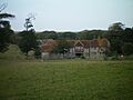
A view of Telscombe Farm.
