Priest Point, Washington facts for kids
Quick facts for kids
Priest Point, Washington
|
|
|---|---|
|
former CDP
|
|

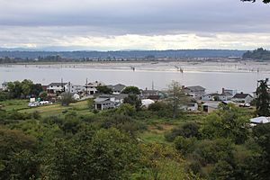
View of Priest Point, Washington from Priest Point Cemetery.
|
|

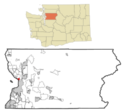
Location of Priest Point, Washington
|
|
| Country | United States |
| State | Washington |
| County | Snohomish |
| Area | |
| • Total | 3.0 sq mi (7.7 km2) |
| • Land | 0.6 sq mi (1.7 km2) |
| • Water | 2.3 sq mi (6.0 km2) |
| Elevation | 95 ft (29 m) |
| Population
(2000)
|
|
| • Total | 779 |
| • Density | 1,209.1/sq mi (466.8/km2) |
| Time zone | UTC-8 (Pacific (PST)) |
| • Summer (DST) | UTC-7 (PDT) |
| FIPS code | 53-56304 |
| GNIS feature ID | 1867628 |
Priest Point is a community located inside the Tulalip Indian Reservation in Snohomish County, Washington, United States. It is a place where people live.
In the year 2000, Priest Point was counted as a "census-designated place" (CDP). This means it was an area defined by the government for collecting population data. At that time, about 779 people lived there. However, by the 2010 census, it was no longer listed as a CDP.
Priest Point is known for having a higher average income compared to many other places in Washington state. It ranked 74th out of 522 areas in the state for its income per person.
History of Priest Point
Early Village Life
Long ago, the Snohomish people had a village at a spot they called Rocky Point. This village was mostly used for temporary homes, especially when it wasn't the rainy season. It was located across the mouth of the Snohomish River from another important village called Hibulb, which is now part of Everett, Washington.
In 2001, some human remains were found during construction work at Rocky Point. This led to a partial excavation of the site to learn more about its past.
Tulalip Reservation and Treaties
Rocky Point became part of the Tulalip Indian Reservation after the 1855 Treaty of Point Elliott. In this treaty, the Snohomish people gave up most of their traditional lands.
Mission School and Its Legacy
In 1857, a group of French Catholic missionaries, called the Missionary Oblates of Mary Immaculate, started a school for Native American children on the Tulalip Reservation. Father Eugene Casimir Chirouse chose the site at Rocky Point for this school. The area was then renamed Priest Point.
They built a log house for the Mission of St. Anne's. Later, the school moved to a new spot on a hillside, where a cemetery was also created nearby. This school received money from the government. It stayed at Priest Point until a fire destroyed it in 1902. A new school campus was then built closer to Mission Beach.
The Priest Point Cemetery has about two dozen unmarked graves. These are the resting places of children who passed away while attending the residential school.
Geography of Priest Point
Location and Landforms
Priest Point is a narrow piece of land, like a finger, that sticks out into Port Gardner. It is located right at the mouth of the Snohomish River.
You can find Priest Point southeast of Tulalip Bay. It is part of the Tulalip Indian Reservation, which is west of the city of Marysville, Washington.
Area and Water Features
According to the United States Census Bureau, Priest Point covers a total area of about 3.0 square miles (7.7 square kilometers). Most of this area is actually water.
About 0.6 square miles (1.7 square kilometers) of Priest Point is land. The remaining 2.3 square miles (6.0 square kilometers), which is about 78% of its total area, is water.
Population and People
Population in 2000
In the year 2000, the census showed that 779 people lived in Priest Point. These people lived in 318 households, and 235 of these were families.
The population density was about 1,209 people per square mile (470 people per square kilometer). There were 344 housing units, meaning homes, in the area.
Diversity of Residents
The people living in Priest Point in 2000 came from different backgrounds.
- About 82% were White.
- About 13% were Native American.
- Smaller percentages were African American, Asian, Pacific Islander, or from other races.
- About 3.5% were from two or more races.
- About 1.7% of the population identified as Hispanic or Latino.
Household Information
Out of all the households, about 28% had children under 18 living with them.
- Nearly 60% were married couples living together.
- About 9% were female householders without a husband present.
- About 26% were non-family households.
- Around 20% of households had just one person living alone.
- About 8% of households had someone aged 65 or older living alone.
The average household had 2.45 people, and the average family had 2.80 people.
Age Distribution
The ages of the people in Priest Point in 2000 varied:
- About 20% were under 18 years old.
- About 6% were between 18 and 24 years old.
- About 25% were between 25 and 44 years old.
- About 33% were between 45 and 64 years old.
- About 15.5% were 65 years old or older.
The median age, which is the middle age of the population, was 44 years. For every 100 females, there were about 102 males.
Income Levels
In 2000, the median income for a household in Priest Point was $52,344. For families, the median income was $59,327.
Men had a median income of $51,184, while women had a median income of $28,333. The average income per person in Priest Point was $26,322.
A small percentage of families (about 5.7%) and people (about 6.9%) lived below the poverty line. This included about 15% of those under 18 and 3% of those 65 or older.
See also
 In Spanish: Priest Point (Washington) para niños

