Princess Anne, Maryland facts for kids
Quick facts for kids
Princess Anne, Maryland
|
|||
|---|---|---|---|

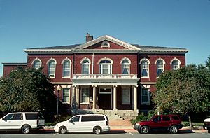
Somerset County Courthouse in Princess Anne
|
|||
|
|||

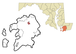
Location in Somerset County and the state of Maryland
|
|||
| Country | |||
| State | |||
| County | |||
| Founded | 1733 | ||
| Incorporated | 1867 | ||
| Area | |||
| • Total | 1.69 sq mi (4.37 km2) | ||
| • Land | 1.67 sq mi (4.33 km2) | ||
| • Water | 0.02 sq mi (0.04 km2) | ||
| Elevation | 18 ft (5 m) | ||
| Population
(2020)
|
|||
| • Total | 3,446 | ||
| • Density | 2,063.47/sq mi (796.76/km2) | ||
| Time zone | UTC−5 (EST) | ||
| • Summer (DST) | UTC−4 (EDT) | ||
| ZIP code |
21853
|
||
| Area code(s) | 410 | ||
| FIPS code | 24-64000 | ||
| GNIS feature ID | 0591074 | ||
Princess Anne is a town in Somerset County, Maryland, United States. It is also the county seat, which means it's where the county government is located. In 2020, about 3,446 people lived here.
Princess Anne is part of the larger Salisbury, Maryland–Delaware Metropolitan Statistical Area. It is also home to the University of Maryland Eastern Shore and the historic Teackle Mansion.
Contents
History of Princess Anne
Princess Anne is a small town located at the start of the Manokin River. It was named after Princess Anne of Great Britain. She was the daughter of King George II.
The town was founded in 1733. It became the county seat for Somerset County. This is the southernmost county in Maryland.
Growth as a Market Center
In the mid-1700s, Princess Anne became very important. It was a busy market center because of trade along the river. Later, the Eastern Shore Railroad was extended south. This helped the town grow even more.
At that time, boats could travel up the Manokin River all the way to the bridge in Princess Anne. This made it a key spot for trade and travel.
Preserving History and Architecture
Many of the old buildings from the town's early days are still standing. About 150 acres of the old town are listed on the National Register of Historic Places. This area is called the Princess Anne Historic District. It includes about 300 historic buildings.
Several other important places in Princess Anne are also on the National Register of Historic Places. These include:
- Adams Farm
- Beckford
- Beverly
- Catalpa Farm
- Glebe House
- Harrington
- Manokin Historic District
- Manokin Presbyterian Church
- Mt. Zion Memorial Church
- Dr. William B. Pritchard House
- Somerset Academy Archaeological Site
- Teackle Mansion
- University of Maryland Eastern Shore
- Waddy House
- Waterloo
- White Hall
Geography and Climate
Princess Anne is located at 38°12′N 75°42′W / 38.200°N 75.700°W.
The United States Census Bureau says the town covers about 1.69 square miles. Most of this area, about 1.67 square miles, is land. A small part, about 0.02 square miles, is water.
Understanding the Climate
The weather in Princess Anne has hot and humid summers. Winters are usually mild to cool. This type of weather is known as a humid subtropical climate. On climate maps, it's often shown as "Cfa."
Population and People
| Historical population | |||
|---|---|---|---|
| Census | Pop. | %± | |
| 1870 | 805 | — | |
| 1880 | 751 | −6.7% | |
| 1890 | 865 | 15.2% | |
| 1900 | 854 | −1.3% | |
| 1910 | 1,006 | 17.8% | |
| 1920 | 968 | −3.8% | |
| 1930 | 975 | 0.7% | |
| 1940 | 942 | −3.4% | |
| 1950 | 1,407 | 49.4% | |
| 1960 | 1,351 | −4.0% | |
| 1970 | 975 | −27.8% | |
| 1980 | 1,499 | 53.7% | |
| 1990 | 1,666 | 11.1% | |
| 2000 | 2,313 | 38.8% | |
| 2010 | 3,290 | 42.2% | |
| 2020 | 3,446 | 4.7% | |
| U.S. Decennial Census | |||
2020 Census Information
The 2020 census showed that 3,446 people lived in Princess Anne.
| Race / Ethnicity | Pop 2010 | Pop 2020 | % 2010 | % 2020 |
|---|---|---|---|---|
| White alone (NH) | 834 | 811 | 25.35% | 23.53% |
| Black or African American alone (NH) | 2,234 | 2,273 | 67.90% | 65.96% |
| Native American or Alaska Native alone (NH) | 5 | 10 | 0.15% | 0.29% |
| Asian alone (NH) | 45 | 44 | 1.37% | 1.28% |
| Pacific Islander alone (NH) | 1 | 0 | 0.03% | 0.00% |
| Some Other Race alone (NH) | 8 | 20 | 0.24% | 0.58% |
| Mixed Race/Multi-Racial (NH) | 69 | 122 | 2.10% | 3.54% |
| Hispanic or Latino (any race) | 94 | 166 | 2.86% | 4.82% |
| Total | 3,290 | 3,446 | 100.00% | 100.00% |
2010 Census Details
In 2010, there were 3,290 people living in Princess Anne. There were 1,276 households and 652 families. The town had about 1,970 people per square mile.
The population was made up of different groups:
- 68.4% African American
- 27.1% White
- 0.2% Native American
- 1.4% Asian
- 0.6% from other races
- 2.4% from two or more races
About 2.9% of the population was Hispanic or Latino.
The average age in town was 24.7 years old.
- 21.6% of residents were under 18.
- 29% were between 18 and 24.
- 23.6% were between 25 and 44.
- 17.7% were between 45 and 64.
- 8.1% were 65 or older.
The population was 40.1% male and 59.9% female.
Colleges and Universities
Notable People from Princess Anne
Many interesting people have connections to Princess Anne:
- Perry H. Carson: An African-American political leader who was born here.
- Samuel Chase: A person who signed the Declaration of Independence. He also served as a Supreme Court justice.
- Charles Chaille-Long: A soldier and explorer.
- Phillips Lee Goldsborough: A former Governor of Maryland and a U.S. senator from Maryland.
See also
 In Spanish: Princess Anne para niños
 | Chris Smalls |
 | Fred Hampton |
 | Ralph Abernathy |


