Principal Cordillera facts for kids
Lua error in Module:Coordinates at line 614: attempt to index field 'wikibase' (a nil value).

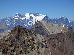
The Principal Cordillera (which means "Main Mountain Range" in Spanish) is a big part of the Andes mountains. It forms the natural border between Central Chile and nearby areas of Argentina. This mountain range is also a continental divide. This means that rain and melted snow falling on one side flow towards the Atlantic Ocean, while water on the other side flows towards the Pacific Ocean.
The Principal Cordillera stretches from north to south. In Argentina, it goes through the provinces of La Rioja, San Juan, and Mendoza. In Chile, it crosses the regions of Valparaíso, Santiago, O'Higgins, and Maule. East of the Principal Cordillera is another mountain range called the Frontal Cordillera, which is entirely in Argentina. Aconcagua, the tallest mountain outside of Asia, is found in the Principal Cordillera.
How the Mountains Formed
Long, long ago, the area where the Principal Cordillera now stands was a low place, like a big bowl. Dirt, sand, and rocks collected here over millions of years. Hot lava from old volcanoes also flowed into this bowl.
Today, if you look high up in these mountains, you can see layers of these old rocks. This tells us that the "bowl" was pushed up and squeezed by powerful forces deep inside the Earth. This process, called "tectonic inversion," started about 21 to 16 million years ago. The mountains continued to rise until about 8 million years ago.
Millions of years ago, the main water divide was about 20 kilometers (about 12 miles) west of where it is today. Over time, rivers carved out valleys, shifting the divide eastward. This left some old, flat areas hanging high up in the mountains. The pushing and lifting of this part of the Andes mountains is still happening today. About 1 million years ago, the Principal Cordillera had risen high enough for large valley glaciers to start forming.
See also
 In Spanish: Cordillera Principal para niños
 | Percy Lavon Julian |
 | Katherine Johnson |
 | George Washington Carver |
 | Annie Easley |

