
Province of Piacenza facts for kids
Quick facts for kids
Province of Piacenza
|
||
|---|---|---|

Palazzo Farnese, Piacenza
|
||
|
||

Map with the province of Piacenza, in red, in Italy
|
||
| Country | ||
| Region | Emilia-Romagna | |
| Province | 1859 | |
| Capital | Piacenza | |
| Comuni | 48 | |
| Area | ||
| • Total | 2,585.86 km2 (998.41 sq mi) | |
| Population
(January 2017)
|
||
| • Total | 286,758 | |
| • Density | 110.8946/km2 (287.2158/sq mi) | |
| Time zone | UTC+1 (CET) | |
| • Summer (DST) | UTC+2 (CEST) | |
| Postal code |
29010, 29020, 29100
|
|
| Telephone prefix | 0523 | |
| ISO 3166 code | IT-PC | |
| Vehicle registration | PC | |
| ISTAT | 033 | |
| Website | Official website: http://www.provincia.piacenza.it | |

The Province of Piacenza (which is Provincia di Piacenza in Italian) is a cool area in the Emilia-Romagna region of Italy. It's like a big county, and its main city is Piacenza. This province is known for its beautiful landscapes, from flat plains to rolling hills and mountains.
Contents
Exploring Piacenza's Geography

The Province of Piacenza covers about 2,586 square kilometers. It's the westernmost province in the Emilia-Romagna region of Italy. The province has two main parts. The northern part is mostly flat. This area is called the Pianura Padana, which is the valley of the Po River.
The southern two-thirds of the province are hilly. These hills eventually rise into the Apennines mountains.
Neighboring Regions and Provinces
Piacenza province shares its borders with several other areas. To the north, it meets the Lombardy region. This includes the Cremona, Lodi, and Pavia provinces.
To the east, it borders the Parma province. To the south, you'll find the Liguria region, specifically the Metropolitan City of Genoa. Finally, to the west, it touches the Piedmont region, with the Alessandria province.
Rivers and Lakes of Piacenza
The most important river in the province is the Po River. It flows through the northern flat areas.
The main lakes in Piacenza province are not natural. They are artificial lakes, meaning they were made by people. Two of these lakes are:
- Mignano (Lago di Mignano): This lake is about 341 meters (1,119 feet) high. It's the biggest lake in the province, covering about 2 square kilometers (0.77 square miles).
- Trebecco (Lago di Trebecco): This lake is a bit higher, at 359 meters (1,178 feet). It has an area of about 73,000 square meters (785,765 square feet).
Piacenza's Highest Point
The highest mountain in the province is Monte Bue. It stands tall at 1,780 meters (5,840 feet) high.
Population in Piacenza Province
As of January 2017, about 286,758 people live in the Province of Piacenza. This means there are about 111 people living in each square kilometer.
The biggest town in terms of population is Piacenza city itself, with over 102,000 residents. Another large town is Fiorenzuola d'Arda, with more than 15,000 people. On the other hand, the town with the fewest people is Zerba, which has only about 78 inhabitants.
How Piacenza Province is Managed
The Province of Piacenza is divided into 48 smaller areas called comuni. Each comune is like a local town or district with its own local government. These comuni vary a lot in size and how many people live in them.
Gallery
-
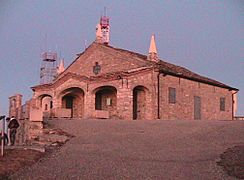
Monte Penice small church
-
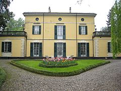
Sant'agata - The country house of Giuseppe Verdi
-
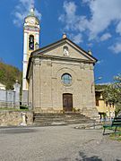
San Michele Arcangelo church, Zerba


See also
 In Spanish: Provincia de Plasencia para niños
