Provinces of Eritrea facts for kids
The provinces of Eritrea were like different parts or states of the country. They existed even before the ancient Kingdom of Aksum. These areas became official administrative provinces when Eritrea was a colony of Italy. Many of these provinces had their own local laws, some as far back as the 1200s. Later, these provinces were changed into new administrative regions.
Contents
How Eritrea Was Divided
When Italian Eritrea was a colony, the Italian government divided it into eight main areas. These were called Akele Guzay, Barka, Denkalia, Hamasien, Sahel, Semhar, Senhit, and Serae. These divisions often followed old political borders that local leaders had used for a long time.
These same provinces were also used by the Eritrean government from 1952 to 1962. When Ethiopia took over Eritrea from 1962 to 1991, these areas were called districts (awrajja).
After Eritrea became independent, the government changed the original eight provinces into nine. They did this by splitting the Barka province into two parts: a northern Barka Province and a southern Gash-Setit Province. They also made Asmara a separate area from Hamasien. Then, on April 15, 1996, the government changed these nine provinces into six new administrative regions.
Akele Guzai
Akele Guzai was a historical province in Eritrea. It existed until 1996, when the Eritrean government reorganized all provinces into six new regions. This province stretched from Dekemhare to the town of Senafe.
Around 1990, about 460,000 people lived in Akele Guzai. It covered an area of 8,400 square kilometers. Most of the people living there were from the Tigrinya and Saho ethnic groups. Akele Guzai was home to more than three-quarters of all Saho-speaking people in Eritrea. Most Tigrinya people in Akele Guzai follow the Eritrean Orthodox Tewahedo Church. The Saho are mostly Sunni Muslim. Today, most of the former Akele Guzai province is part of the Northern Red Sea Region and the Southern Region.
History of Akele Guzai
Akele Guzai is one of the oldest parts of Eritrea. Ancient writings found here date back to at least the 9th century BC. This is where the earliest examples of the Ge'ez script were found. The province was once part of the ancient kingdom of Dʿmt, which later grew into the powerful Kingdom of Aksum.
Akele Guzai was a major center of Aksumite culture. It was very important, second only to Seraye, where the capital of Aksum was located. It had its own special sub-culture that was different from the central Aksumite lands of Seraye and Hamassien, and also from the coastal area of Adulis.
In the Middle Ages, some southern parts of Akele Guzai were briefly part of a larger province called Bur.
Barka
Barka was a province of Eritrea until 1996. At that time, it was divided into two of today's regions: Gash-Barka and Anseba. The capital city of Barka was Agordat. It covered an area of about 20,630 square kilometers.
Denkalia
Denkalia was another province of Eritrea until 1996. It was then divided and became part of the present-day Northern Red Sea and Southern Red Sea regions of Eritrea. Its capital city was Assab.
Hamasien
Hamasien (written ሐማሴን in Ge’ez and ሓማሴን in Tigrinya) was a historical province. It included and surrounded Asmara, which is now the capital of Eritrea. In 1987, Hamasien province had about 623,000 people and covered an area of 4,400 square kilometers. In 1996, the province was divided. Its land was spread among the modern Maekel, Debub, Northern Red Sea, Gash-Barka, and Anseba regions.
Most people in Hamasien follow Oriental Orthodox Christianity and are members of the Eritrean Orthodox Tewahdo Church. There are also many Sunni Muslim, Roman Catholic, and Lutheran communities. Hamasien was a very important and powerful area in the Eritrean highlands.
History of Hamasien
The former province of Hamasien was the main political and economic center of Eritrea. Old excavations in the Sembel area near Asmara show that it has been important since at least the 9th century BC. The name "Hamasien" might have first appeared in an ancient writing from the Axumite king Ezana.
During the early medieval centuries, local leaders ruled Hamasien. Later, a governor known as the Bahr Negash ruled Hamasien during the Zagwe and Solomonic dynasties.
Hamasien appears on old maps of the northern Horn of Africa from the 1400s. In the 1500s, a chief called Zarsanāy governed it during the time of the Adal Sultanate.
After the importance of the Midri Bahri region declined in the 1600s, Hamasien was governed by councils of village elders. These elders, called shimagile, made sure that traditional laws were followed. After Emperor Yohannes died, the Italians took over Hamasien. They made it part of their colony of Eritrea and chose Asmara, a village in Hamasien, as the capital. Asmara is still the capital of Eritrea today.
Sahel
Sahel was a former province of Eritrea. It existed until 1996, when it became part of the present-day Northern Red Sea region. Its capital city was Nakfa.
Semhar
Semhar was another former province of Eritrea. Most of it is now part of the Northern Red Sea Region. This change happened in 1996 when the provinces were reorganized. The province was not very crowded, and Massawa was its capital city.
The people living in Semhar were mainly from the Tigre, Afar, Saho, and Tigrinya ethnic groups. The Tigre and Tigrinya languages were mostly spoken. Most people in this area were pastoralists (herders) or agro-pastoralists (both farming and herding).
Semhar is also a common name for girls in Eritrea, and sometimes for boys too. There is also a city named Semhar in Eritrea.
Senhit
Senhit was a former province of Eritrea. It existed until 1996, when it was absorbed into the present-day Anseba region. Its capital city was Keren.
Serae
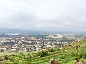
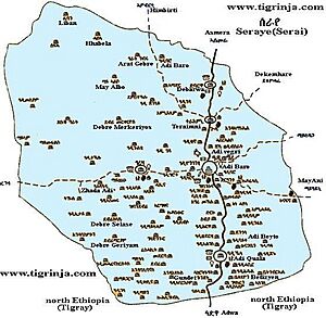
Serae or Seraye (written ሰራየ in Tigrigna, Tigre, and Ge’ez) was a former province of Eritrea. In 1990, it had an estimated population of 515,000 people, making it the most populated province. It covered an area of 8,608 square kilometers.
The province is home to two of Eritrea's ethnic groups: the Tigrinya and Tigre. Most of Serae is now part of the Debub Region. However, some western areas have become part of the Gash-Barka region. People believe the name of the province comes from the "dark forests" that once grew on its rich land.
Today, the region has twelve monasteries of the Eritrean Orthodox Church. It also has several new factories in the town of Mendefera.
Districts of Serae
- Tsilima ጽልማ
- Debub ደቡብ
- GuH'tsi'A ጉሕጭዓ
- Mai Tsa'eda ማይጻዕዳ/ ማጫዕዳ
- Enda Azmach Oqbit እንዳዝማች ዑቕቢት
- Deqi Bokhri ደቂ ቦኽሪ
- Meraguz መራጉዝ
- QoHain ቆሓይን
- Gundet ጒንደት
- Aila ዓይላ
- Sef'a ሰፍኣ
- Harfe Gurotto ሃርፈጒረቶ
- Deqi Digna ደቂ ድግና
- Deqi Aites ደቂ ጣዒስ
- Medri Wedi’Sebera ምድሪ ወዲ’ሰበራ
- Dembelas ደምበልስ
- Zaide'kolom ዛይደ'ኮሎም
- Anagir ዓናግር
- Tekela ተኸላ
- Kuno Redae ኲኖ ረዳእ
- Etan Zere ዕጣን ዘርአ
- Misyam ምስያም
- Medri Felasi ምድሪ ፈላሲ
- Timzea - ትምዝኣ
History of Serae
Serae, also called Sarawi in old books, is a very old area. It was a region of the Kingdom of D'mt, which later became the Kingdom of Aksum. During the Zagwe and Solomonic dynasties, the Bahr Negash (a type of governor) was based in Debarwa in the province of Seraye.
Historically, Serae included parts of Tigray. It was home to the Aksumite capital, Axum town. Serae was bordered by Akele Guzay to the east, Hamassien to the north, and other regions to the south and west. During the Aksumite period, Serae became a successful trading area. This was because it was located between the Red Sea port of Adulis, Asmara, and Axum.
In his ancient writings, King Ezana mentioned that he had taken control of 'Sarawi' (which is believed to be Serae). He also said he made an agreement with its ruler for trade caravans to pass peacefully through their country to Adulis.
After the fall of Aksum as a united kingdom in the 8th century AD, Serae became an independent state. It was ruled by its own leader, called 'Cantibai'.
Serae appears on old maps of the northern Horn of Africa from the 1400s.
The Bahr Negash continued to exist until the 1600s. The province of Serae had its own written local laws, used since the early 1400s. This law book was called the law of Adkeme-Miligae. Sadly, this book was lost or burned during a conflict in the 1600s. After that, the people of Serae followed their laws verbally until the Italians arrived in the late 1800s. In 1938, the local law code was written down again. This was done by wise elders from seven villages. This law had more open customs and fewer restrictions on women's rights to own land than other laws in the country.
Today, most of Serae and Akeleguzay are together inside the Southern region of Eritrea.
See also
- Regions of Eritrea
 | Jackie Robinson |
 | Jack Johnson |
 | Althea Gibson |
 | Arthur Ashe |
 | Muhammad Ali |


