
Asmara facts for kids
Quick facts for kids
Asmara
|
||
|---|---|---|
| ኣስመራ |
||

|
||
|
||

Asmara
Location in Eritrea

Asmara
Location in Africa
.svg)
Asmara
Location in Earth
|
||
| Country | ||
| Region | Central | |
| Districts | 13 | |
| Demonym | Asmarino | |
| Settled | 800 BC | |
| Incorporated | 1890 | |
| Area | ||
| • Capital city | 45 km2 (17 sq mi) | |
| Elevation | 2,325 m (7,628 ft) | |
| Population
(2023)
|
||
| • Capital city | 1,073,000 | |
| • Rank | 1st in Eritrea | |
| • Density | 19,911/km2 (51,570/sq mi) | |
| • Metro | 1,258,001 | |
| Time zone | UTC+03:00 (East Africa Time) | |
| • Summer (DST) | (Not Observed) | |
| HDI (2019) |
|
|
| Climate | BSk | |
| UNESCO World Heritage Site | ||
| Official name | Asmara: A Modernist African City | |
| Criteria | Cultural: ii, iv | |
| Inscription | 2017 (41st Session) | |
| Area | 481 ha | |
| Buffer zone | 1,203 ha | |

Asmara (pronounced əs-MAHR-ə), also called Asmera, is the capital city of Eritrea. It is also the largest city in the country. Asmara is located in Eritrea's Central Region.
The city sits very high up, at about 2,325 metres (7,628 ft) above sea level. This makes it one of the highest capital cities in the world. Asmara is found at the edge of a steep slope, which is part of the Eritrean Highlands. In 2017, UNESCO named Asmara a World Heritage Site. This was because of its amazing and well-kept modernist architecture.
Local stories say that Asmara was formed when four villages decided to join together. They wanted to live in peace after a long time of fighting. Asmara became very important in the 20th century when it became the capital of Italian Eritrea. During Italian rule, the city grew quickly and became very modern.
Contents
A Look at Asmara's Past
How Asmara Began
According to old stories from Eritrea, four groups of people lived in the Asmera area. These groups were often attacked by others from the lowlands. The women from each group decided that for peace, the four groups should unite. The men agreed, and that's how the name "Arbate Asmera" came about. In the Tigrinya language, "Arbate Asmera" means "the four (women) made them unite."
The first time Asmara was mentioned in writing was during the rule of Emperor Dawit I (1382–1411).
Asmara Under Italian Rule
Asmara was a small village until Italy took control in 1889. It then started to grow very fast. In 1897, Governor Ferdinando Martini made it the capital city of Italian Eritrea.
In the early 1900s, the Eritrean Railway was built to connect the city to the coast. This helped Asmara grow even more. The city also survived two big earthquakes in 1913 and 1915 with only minor damage.
A large number of Italian people moved to Asmara and helped build the city. By 1939, Asmara had 98,000 people, and 53,000 of them were Italian. This made Asmara the biggest Italian center in Eritrea.
The city started to look very Italian. Europeans used Asmara to try out new and bold building designs. By the late 1930s, Asmara was known as Piccola Roma, meaning "Little Rome." Many buildings today are still Italian, and some shops even have Italian names.
Italy invested in building factories and businesses in Asmara. However, the start of World War II stopped this growth.
In July 2017, UNESCO recognized Asmara as a World Heritage Site. They said it was a great example of early modern city planning in Africa.
Becoming Independent
In 1952, the United Nations decided that Eritrea would join with Ethiopia. During this time, Asmara was no longer the capital city. The capital moved to Addis Ababa, which was far to the south. In 1961, Emperor Haile Selassie I ended this arrangement and made Eritrea a province of Ethiopia.
The Eritrean War of Independence began in 1961 and lasted until 1991. This war led to Eritrea becoming an independent country. Asmara was not badly damaged during the war. After Eritrea gained independence, Asmara became its capital city once again.
Asmara's Location and Weather
Where Asmara Is Located
The city is located about 2,325 metres (7,628 feet) above sea level. It sits on high lands called the Eritrean Highlands. These highlands are a part of the Ethiopian Highlands. Asmara is in the central part of these highlands, on a rocky plateau. This plateau separates the lowlands to the west from the coastal plains to the east.
The land around Asmara is very good for farming, especially to the south. The highlands where Asmara is located drop down to the eastern lowlands. These lowlands are very hot and humid, with salt flats near the Red Sea. To the west of the plateau, there are dry, hilly areas that stretch towards the border with Sudan.
Asmara's Climate


Asmara has a cool semi-arid climate. This means it's generally dry but not extremely hot. The weather is moderately warm all year. Temperatures usually stay between −4.5 °C or 23.9 °F and 31.0 °C or 87.8 °F. The city gets most of its rain in July and August. Other months have less rain.
Asmara has warm summers, but they are not too hot. Winters are mild. Because of its high altitude, the temperatures are much milder than in other hot parts of the country. Asmara gets about 518 mm (20.4 in) of rain each year. It almost never freezes in the city.
The long dry season lasts from September to April. Some showers happen from April to June. About 60% of Asmara's yearly rain falls in July and August. December to February are the driest months.
Asmara's climate can also have droughts, which means long periods with little rain. These droughts have happened often since the 1960s. When there is a drought, temperatures are high and there is little rain. This can lead to the soil becoming like a desert. To get good soil for farming, people sometimes cut down trees. The biggest environmental problems in Asmara are cutting down too many trees and the land turning into desert. Other issues include soil erosion and too much grazing by animals. All these problems harm the soil.
| Climate data for Asmara, Eritrea (1961–1990 normals, extremes 1903–2012) | |||||||||||||
|---|---|---|---|---|---|---|---|---|---|---|---|---|---|
| Month | Jan | Feb | Mar | Apr | May | Jun | Jul | Aug | Sep | Oct | Nov | Dec | Year |
| Record high °C (°F) | 29.0 (84.2) |
29.2 (84.6) |
30.5 (86.9) |
31.0 (87.8) |
30.0 (86.0) |
29.4 (84.9) |
29.4 (84.9) |
27.4 (81.3) |
27.2 (81.0) |
31.0 (87.8) |
26.7 (80.1) |
26.2 (79.2) |
31.0 (87.8) |
| Mean daily maximum °C (°F) | 22.3 (72.1) |
23.8 (74.8) |
25.1 (77.2) |
25.1 (77.2) |
25.0 (77.0) |
24.9 (76.8) |
21.6 (70.9) |
21.5 (70.7) |
22.9 (73.2) |
21.7 (71.1) |
21.5 (70.7) |
21.5 (70.7) |
23.1 (73.6) |
| Daily mean °C (°F) | 13.8 (56.8) |
14.9 (58.8) |
16.3 (61.3) |
17.0 (62.6) |
17.6 (63.7) |
17.6 (63.7) |
16.3 (61.3) |
16.1 (61.0) |
15.7 (60.3) |
14.9 (58.8) |
14.0 (57.2) |
13.2 (55.8) |
15.6 (60.1) |
| Mean daily minimum °C (°F) | 4.3 (39.7) |
5.1 (41.2) |
7.5 (45.5) |
8.7 (47.7) |
10.2 (50.4) |
10.5 (50.9) |
10.8 (51.4) |
10.7 (51.3) |
8.6 (47.5) |
8.1 (46.6) |
6.6 (43.9) |
4.8 (40.6) |
8.0 (46.4) |
| Record low °C (°F) | −4.5 (23.9) |
−1.6 (29.1) |
−0.8 (30.6) |
−0.2 (31.6) |
2.0 (35.6) |
3.4 (38.1) |
3.9 (39.0) |
3.7 (38.7) |
0.2 (32.4) |
1.0 (33.8) |
−0.5 (31.1) |
−1.4 (29.5) |
−4.5 (23.9) |
| Average precipitation mm (inches) | 3.7 (0.15) |
2.0 (0.08) |
14.6 (0.57) |
33.4 (1.31) |
41.1 (1.62) |
38.5 (1.52) |
174.9 (6.89) |
155.6 (6.13) |
15.6 (0.61) |
15.4 (0.61) |
20.4 (0.80) |
3.4 (0.13) |
518.6 (20.42) |
| Average rainy days (≥ 1.0 mm) | 0 | 0 | 2 | 4 | 5 | 4 | 13 | 12 | 2 | 2 | 2 | 1 | 47 |
| Average relative humidity (%) | 54 | 48 | 46 | 49 | 48 | 48 | 76 | 80 | 59 | 63 | 66 | 61 | 58.2 |
| Mean monthly sunshine hours | 291.4 | 260.4 | 275.9 | 264.0 | 257.3 | 219.0 | 151.9 | 158.1 | 213.0 | 272.8 | 276.0 | 282.1 | 2,921.9 |
| Percent possible sunshine | 84 | 81 | 75 | 71 | 65 | 57 | 38 | 41 | 59 | 76 | 82 | 82 | 67 |
| Source 1: NOAA | |||||||||||||
| Source 2: Meteo Climat (extremes) | |||||||||||||
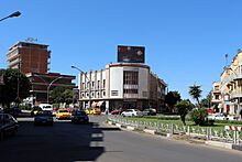
Culture and Architecture
Asmara's Culture


Asmara is home to the Eritrean National Museum. This is a great place to learn about the country's history and culture. The city is also often the starting point for the Tour of Eritrea, a famous bicycle race.
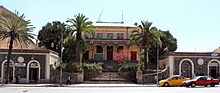
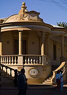
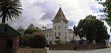
Unique Buildings of Asmara
Asmara is famous for its buildings from the early 1900s. These include:
- The Art Deco Cinema Impero, which opened in 1937. Experts say it's one of the best examples of Art Deco style in the world.
- The Cubist Africa Pension.
- The Eritrean Orthodox Enda Mariam Cathedral.
- The old Opera House.
- The futuristic Fiat Tagliero Building.
- The neo-Romanesque Church of Our Lady of the Rosary, Asmara.
- The neoclassical Governor's Palace.
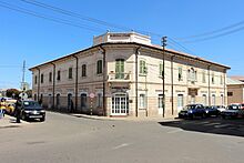
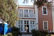
Many Italian-style villas and mansions also decorate the city. A good example is the World Bank Building. Most of central Asmara was built very quickly, between 1935 and 1941. The Italians managed to build almost an entire city in just six years!
Asmara shows off many different building styles from the early 20th century. Some buildings are neo-Romanesque, like the Church of Our Lady of the Rosary. Some villas are in a late Victorian style. You can see Art Deco influences all over the city. There are even hints of Cubism on the Africa Pension Building. The Fiat Tagliero Building is a great example of futurism, a style that was very popular in Italy at the time.
Asmara is known for being a very modern city. It even had more traffic lights than Rome when it was being built! The city was carefully planned, with many modern features.
Food and Cafes
Asmara has wide streets, many restaurants, and lovely town squares (called piazzas). There are also lots of bars and cafes. Many of the main streets are lined with palm trees.
The Italian food and culture are very strong in Asmara. This was brought in during the time of Italian Eritrea. You can find many restaurants and cafes that serve excellent espresso, cappuccinos, and lattes. There are also gelato shops and restaurants with Italian Eritrean cuisine. Some common dishes include 'Pasta al Sugo e Berbere' (pasta with tomato sauce and a spice called berbere), "lasagna", and "cotoletta alla milanese" (a type of breaded cutlet).
.jpg)
.jpg)

Asmara: A UNESCO World Heritage Site
Asmara was officially named a UNESCO World Heritage Site in July 2017. It was the first time a whole city built in the modernist style was given this honor. This happened during the 41st World Heritage Committee Session.
The city has thousands of buildings in Art Deco, futurist, modernist, and rationalist styles. These were built when Eritrea was an Italian colony. The city is nicknamed "La piccola Roma" ("Little Rome"). It is located over 2,000 meters above sea level. This high location meant the climate was cooler, which was perfect for building. Architects used both Italian and local materials.
Some well-known buildings include the Fiat Tagliero Building, Bar Zilli, opera houses, hotels, and cinemas like the Cinema Impero.
UNESCO stated:
It is an exceptional example of early modernist urbanism at the beginning of the 20th century and its application in an African context.
- Some buildings included in the UNESCO World Heritage Site list for Asmara:
-
Teatro d'Opera, the opera house of Asmara.
-
A building at the University of Asmara.
-
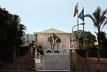
Villa Roma, Italian embassy.
-

The Fiat Tagliero Building.
-
Hotel (Albergo) Italia, built 1889. The hotel is one of the oldest hotels in Asmara
-
The African pension.
-
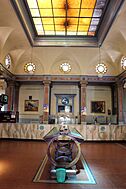
Interior of Asmara post office.
-
The Embasoira built 1919 (Old Imperial hotel), celebrated 100 years in 2019.
-
The Casa degli Italiani restaurant.
-
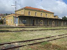
The railway station in Asmara.
-
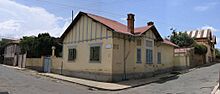
An old house in the European quarter.
-
Bar Zilli, architecturally modeled in accordance with the Art Deco movement in the 1930s.


.JPG)


The Historic Center of Asmara was put on the World Monuments Fund's 2006 Watch List of 100 Most Endangered Sites. This was done to bring more attention to the city. The goal was to save the center from decay and to encourage its restoration.
The European Union has also started a project to restore buildings and manage historical records in Asmara. This project began in 2010.
Religion in Asmara

Asmara has four important religious landmarks:
- The Church of Our Lady of the Rosary (Catholic).
- The Kidane Mehret Cathedral (Catholic, Coptic rite).
- The Enda Mariam Cathedral of the Eritrean Orthodox Tewahedo Church.
- The Al Khulafa Al Rashiudin Mosque (Islamic).
Most people in the Central Region, where Asmara is, are Christian (mostly Orthodox, with some Roman Catholic and Protestant). A smaller part of the population is Muslim.
Asmara is also the main center for the Eritrean Orthodox Tewahedo Church. This church became independent in 1993. In 1998, its leader was given the title of Patriarchate of Eritrea, similar to the Ethiopian Orthodox Tewahedo Church.
Asmara's Economy
Several important companies have their main offices in Asmara. These include Eritrean Airlines and the Eritrean Telecommunications Corporation. The country's national TV station, Eri-TV, also has many studios in the capital.
The Asmara Brewery, built in 1939, is located in the city. It employs 600 people. The brewery makes Asmara beer and other drinks like rum and gin. It also sponsors the local football team, Asmara Brewery FC, also known as "Asmara Birra" (which means "Asmara Beer").
Getting Around Asmara

After Eritrea became independent, many roads in Asmara were built or improved. Old roads were fixed, and new highways were added. There are five main roads that lead out of Asmara.
Asmara International Airport serves the city with many flights to other countries. Massawa International Airport is another airport nearby.
Eritrea has a narrow-gauge railway line. The Eritrean Railway was built between 1887 and 1932. It was badly damaged during WWII and later conflicts, and parts of it were closed. The railway was fully closed in 1978. After Eritrea gained independence, efforts began to rebuild it. The first rebuilt section opened in 2003. By 2009, the section from Asmara to Massawa was fully rebuilt and ready for use.
Education in Asmara
Asmara has always been a key center for education in Eritrea. It is home to many elementary and high schools. The University of Asmara was in the city from 1958 until it closed in 2006. This happened after a new university opened at Mai Nefhi.
Universities and Colleges
- University of Asmara (1958-2006)
- Eritrea Institute of Technology
Primary and Secondary Schools
International Schools
- Asmara International Community School – an international school where English is spoken.
- Italian School of Asmara – an Italian primary school with a Montessori department (1903-2020).
Secondary Schools
- Shek Ibrahim Sultan Secondary School
- Red Sea Secondary School
- Barka Secondary School
- Limeat Secondary School
- Halay Secondary School
- Hafeshawi Secondary School
- Isaac Tewoldemedhn High School
- Semaetat Secondary School
Districts of Asmara
Asmara is divided into 13 districts, also called administrative areas. These districts are grouped into North, North-West, North-East, South-East, South-West, East, West, and Central areas. The thirteen districts (or Neous Zobas) are:
- North
- Akhria District
- Abbashaul District
- Edaga Hamus District
- North-East
- Arbaete Asmara District
- North-West
- Mai Temenai District
- Paradiso District
- South-West
- Sembel District
- South-East
- Kahawuta District
- Godaif District
- Central
- Maakel Ketema District
- West
- Tiravolo District
- Tsetserat District
- East
- Gheza Banda District
- Gejeret District
Notable People from Asmara
- Asmeret Asefaw Berhe, a scientist who studies soil.
- Abraham Afewerki, a popular singer and music producer.
- Isaias Afwerki, the President of Eritrea.
- Tsehaytu Beraki, a popular Eritrean musician.
- Yemane Barya, a famous Eritrean singer and musician.
- Tedros Adhanom Ghebreyesus, the head of the World Health Organization.
- Remo Girone, an Italian actor.
- Biniam Girmay, a professional bicycle rider.
- Bruno Lauzi, an Italian singer and writer.
- Dawit Isaak, a Swedish-Eritrean journalist.
- Meb Keflezighi, an American long-distance runner born in Eritrea.
- Gianfranco Rosi, an Italian film director.
- Mehari Shinash, an Eritrean footballer.
- Mussie Zerai, a Catholic priest and activist who helps people seeking asylum.
Images for kids
-
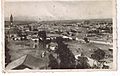
Asmara in 1935
-
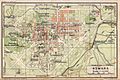
Map of Italian Asmara in 1929
.jpg)

See also
 In Spanish: Asmara para niños
